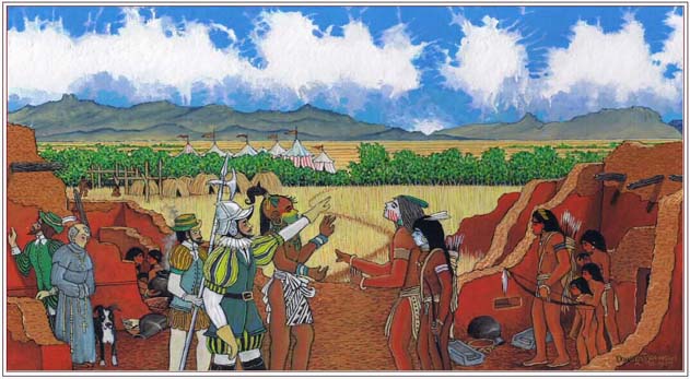
The Red House Camp and the Captain General
The 2009 Report on the Coronado Expedition Campsite at Chichilticale
My exploration for the course of the Coronado Trail through southeastern Arizona and southwestern New Mexico and for the location of Chichilticale, one of Capt. Gen. Francisco Vßzquez de CoronadoÆs encampments, began in September 2004. In early 2006, our team discovered artifacts suggesting that we had found the Coronado Expedition camp at Chichilticale. In the fall of 2007, the New Mexico Historical Review published my first report concerning this exploration program and the initial field season.1 This second report, finalized in the fall of 2008, provides additional information about the first three seasons of exploration at the site, offers a current report on activities, and strengthens the identification of sixteenth-century Spanish artifacts found at Kuykendall Ruins with the Coronado Expedition encampment at Chichilticale.
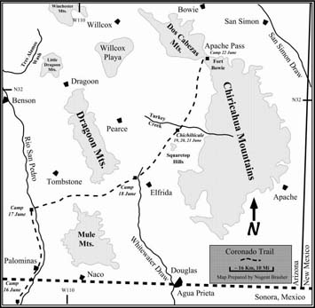
From the beginning of my search for CoronadoÆs camp at Chichilticale, I considered the appropriate process to be fundamentally the same as the philosophy and guidelines that I have employed to locate future petroleum reserves. The deliberately selected data that I consulted for exploration of Coronado and Chichilticale were only the original and untranslated Spanish documents. I generated maps based on my interpretation of those documents and from personal field observations. I concluded that the puzzle could be solved by asking two fundamental questions: ōWhere did they turn to the right, and where did they climb up?ö The following map was published in the Fall 2007 issue of the New Mexico Historical Review. It illustrates the ōturn-to-the-rightö at Lewis Spring, shown as Camp June 17. The route beyond Fort Bowie was purposely omitted.
After I decided that Coronado turned right at Lewis Spring, and that the expedition climbed up alongside Blue Creek, the approximate location of Chichilticale became apparent. The obvious choice was Kuykendall Ruins. To test my hypothesis, I employed the best technology and equipment to search for Coronado-era artifacts, conducting field operations based not on traditional protocol but on improvisation, innovation, and expediency.
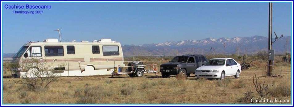
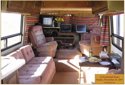
Our initial field season extended from 8 December 2005 to 12 April 2006, during which time we stayed in motels in Willcox, Arizona. To maximize the efficiency of exploration at Chichilticale after the first season, my team established a semipermanent facility to accommodate us ¢ a motorcoach remodeled to serve as a field camp and headquarters. To support the coach at the camp, we installed electrical power, telephone and internet service, a water supply, and septic facilities.
Team members occupied the base camp during the second field season for the five months from 8 November 2006 to 10 April 2007. The third season lasted from 6 November 2007 to 11 April 2008. During all three field seasons we implemented innovative and flexible research designs produced under the guidance of anthropologist Carroll L. Riley of Las Vegas, New Mexico, and archaeologist Karl W. Laumbach of Human Systems Research in Las Cruces, New Mexico.
Surface Reconnaissance
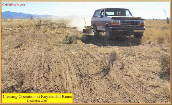
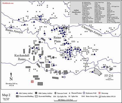
The teamÆs sole purpose during the first field season was to confirm the hypothesis that the Kuykendall Ruins were, indeed, Chichilticale. The requirements changed, however, after the first field season because we had indeed made what we perceived to be an authentic discovery. To verify it, the Red House site had to be investigated to ascertain its extent and detail. Although the artifacts found during the first field season encouraged team members to continue the search, the spatial distribution of the discovered artifacts did not predict where other residuals of the Coronado Expedition would be found. To conduct a dependable and thorough search of Chichilticale, we first had to investigate the setting methodically. We therefore devoted the opening of the second field season to a surface reconnaissance of Kuykendall Ruins and their surroundings. Map 1 displays the regional setting of the Kuykendall site and outlines the area reconnoitered.
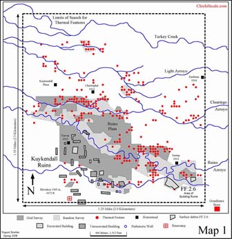
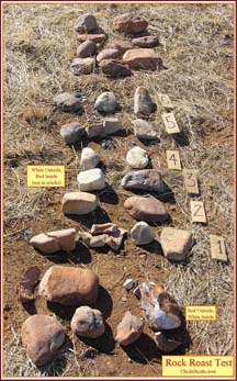
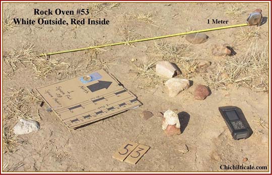
One result of this reconnaissance was the recognition of numerous and distinct lithic features, which appeared to be fire-burned rocks. On 10 December 2006, I showed the fired rocks to archaeologist Deni J. Seymour, who recommended the construction of a database containing the specific physical and numerical attributes of each lithic feature. Using a data sheet designed by Seymour, I built such a database and spotted the features on a Digital Ortho Quarter Quad (DOQQ) base. The locations of these features are shown on Map 1, and the following montage displays a comparison of various thermal features.
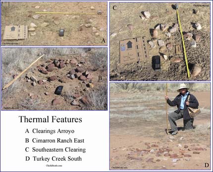
My early mapping clearly demonstrated that the piles of fired rocks were geomorphologically controlled and that their locations were predictable. I used this observation to widen my search, and I determined that the features occurred in clusters and were mostly restricted to locales along presently extinct arroyos in the region around Kuykendall Ruins. Lithics used to construct the thermal features were cobbles obtained from the abandoned, mostly buried arroyos. The positive correlation between thermal features and arroyos suggests that, at the time the rock features were constructed, the arroyos offered exposed cobbles, likely due to the presence of pooled or flowing water, and trees lined the streams and provided fuel for the fires, as well as shade for travelers. This rock-water-fuel-shade relationship would have attracted transient, expedient fire builders.
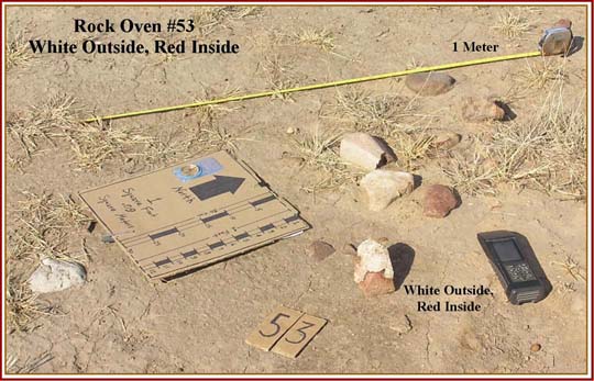
Team members hypothesized that the thermal features were the campfires of the Coronado Expedition. To explore this possibility, we conducted controlled experiments at the base camp to determine the impact of fire on arroyo cobbles obtained from Clearings Arroyo and Ruins Arroyo. The cobbles were heated for specific lengths of time in oak fires of various sizes. These experiments demonstrated the color changes imposed and fracturability inflicted on the rocks by the fires. Of particular interest was that some rocks turned white on the outside and red on the inside, while others changed exactly the opposite, that is, red on the outside, white on the inside. We concluded that many of the observed and measured thermal features had been caused by fires of only a brief duration.
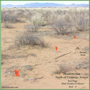
The anomalous cluster of thermal features along Clearings Arroyo spurred considerable interest. All these features, without exception, were located on the north side of that extinct stream and most exhibited color and fracture characteristics consistent with fires of short duration. The majority of the Clearings Arroyo features contained few rocks. Distribution of the principal cluster of these thermal features was terminated to the east and west along the north side of the arroyo (this termination was not caused by agricultural land alteration). These physical and spatial characteristics suggested brief usage by a large homogenous party in a selected space. Coronado scholar Richard Flint has suggested that such a party might have been a distinct group of the Coronado Expedition.
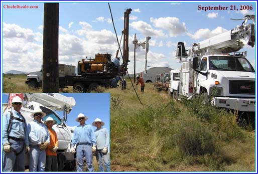
Recognition of the thermal features impacted my plan to conduct a magnetometer survey during the second season for the purpose of exploring for hearths that might contain datable bones or carbon.2 The discovery of hundreds of thermal features on the surface caused the magnetometer survey to be held in abeyance until the thermal features had been analyzed and considered.
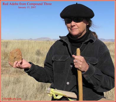
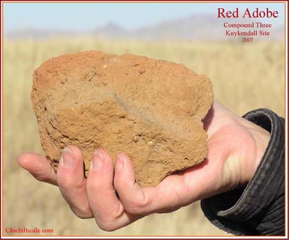
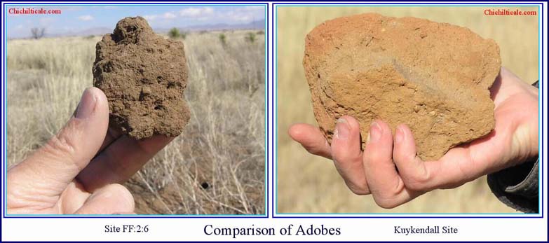
The teamÆs pedestrian surface reconnaissance of the Kuykendall Ruins discovered large and small pieces of red adobe. Avocational archaeologists Jack and Vera Mills reported red adobe at specific rooms in Compounds One, Two, and Four.3 Our search located pieces likewise at Compounds One, Three, and Four, and at an unnumbered compound west of Compound Five. We found the red adobe where digging had occurred after the Millses completed their excavations.4 Finding red adobe at Compound Three and at the unnumbered compound suggests that the material was more widespread at Kuykendall Ruins than the Millses reported.
The pedestrian surface reconnaissance also included archaeological site FF:2:6, located about three-quarters of a mile east of Compound One at Kuykendall Ruins.5 The quantity of artifacts and building material exposed on the surface at site FF:2:6 are not comparable to such exposures at Kuykendall Ruins. Although a careful search was conducted for adobe, including examining holes dug by intruders, only a few pieces were found on a single rodent mound, and these adobes were brown as opposed to red.
Geological Survey
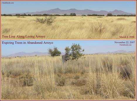
Throughout the first field season, I thought that Turkey Creek would be a likely site of the Spanish camps. The trees, water, and comforts offered by that stream would have been alluring to Coronado and his men. Therefore, I examined the environs of Turkey Creek north of Kuykendall Ruins during my surface reconnaissance. To my surprise, I observed relatively little cultural material along its banks; potsherds, thermal features and chipped rock were almost totally absent, and this discovery sharply contrasted with the abundance of human-produced debris and other material found along Ruins Arroyo and Clearings Arroyo.
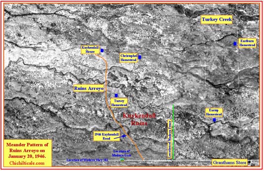
Map 1 shows that the principal drainage feature associated with Kuykendall Ruins, a dry watercourse we named Ruins Arroyo, is a meandering stream, whereas all other arroyos in the area demonstrate a predominantly linear course. The meandering course is clearly shown on a 1946 aerial photograph.
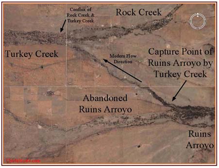
This meandering pattern, I hypothesized, indicated that Ruins Arroyo was a stream older than its neighborsŚClearings Arroyo, Light Arroyo, and Turkey CreekŚwith relatively linear drainage and that Ruins Arroyo was the principal stream when Natives occupied the Kuykendall village and the Coronado Expedition visited the abandoned ruin. The abundance of archaeological features along Ruins Arroyo and the relative paucity of such archaeological features along critical stretches of Turkey Creek, the contemporary principal drainage, support my contention about relative stream ages and suggest that Turkey Creek may have captured the flow of Ruins Arroyo sometime after 1542. In that case, Coronado would likely have chosen Ruins Arroyo, rather than Turkey Creek, for a campsite.
I considered whether the 1887 earthquake in the San Bernardino Valley of Sonora, Mexico, might have caused the watercourse alteration. Geologists Susan M. DuBois and Ann W. Smith have reported, ōWidespread effects of the vibrations on groundwater and surface flow were evident [in the Yaqui, Fronteras, San Bernardino, Sulphur Springs, and San Pedro valleys].ö New springs appeared, some lakes and springs disappeared, and water levels in others changed.6 To obtain a professional opinion on my geological hypothesis, I invited the Arizona Geological Survey to the Kuykendall site. On 17 May 2007, three Arizona state geologistsŚPhilip A. Pearthree, Ann Youberg, and Joseph P. CookŚand I conducted a field examination that included Ruins Arroyo, Ruins Plain, and Clearings Arroyo. On 6 June 2007 I received two aerial photographs and a written report that states:
Based on the character of the channel evident on the photo and the associated vegetation, the northwest-oriented path [of Turkey Creek] is clearly dominant now. . . . The presence of some trees downstream of the split on the more westerly path [of Ruins Arroyo] suggests that some water heads that way during floods, however. Another interesting thing about the distributary split is that the valley associated with the western split [Ruins Arroyo] appears to be a lot wider than the NW split [Turkey Creek]. This could be interpreted as evidence that the NW split [Turkey Creek] has developed fairly recently, and that over time lateral stream erosion or deposition would widen that valley. In any case, it is reasonable to presume that the western branch [Ruins Arroyo] has carried more flow in the past, and perhaps not all that long ago. When that was the case, several washes that are relatively minor now, like Ruins Arroyo, might have been linked directly to the western split and carried a lot more water.
The report supported my stream capture hypothesis by describing Turkey Creek as splitting off to the northwest from westerly trending Ruins Arroyo.7
The Arizona Geological Survey provided me with digital aerial photographs taken in 1946 and 1979. Combining these with my 2003 DOQQ and my 2006 GoogleEarth image, I was able to observe changes in stream patterns. I explored the various abandoned arroyos for archaeological evidence. By placing locations of prehistoric archaeological features and historic artifacts on these images, I was able to generate a geological-geoarchaeological model suggesting that Turkey Creek north of Kuykendall Ruins became the dominant stream only after 1800 but before the 1887 earthquake. Prior to 1800, Clearings Arroyo and Ruins Arroyo were the principal watercourses, enjoying pools and running water that supported trees for fuel wood, and exposed stream cobbles for use with fires.
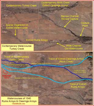
My model explains why Coronado would not have camped at the contemporary Turkey Creek, instead choosing what are now dry, treeless Ruins and Clearings arroyos. The model demotes Turkey Creek to a lower-level prospect and elevates Ruins and Clearings arroyos to higher-tier prospects.
Exploration Technology Employed
During the initial season team members surveyed with handheld metal detectors. To facilitate the metal-detector survey, team member Gordon Fraser used an elevated metal broom pulled by a vehicle to remove the low vegetation from the site.
For the second season, team member John Blennert donated a MineLab GP3000 detector configured to a sled holding a Coil-Tek 40ö x 20ö DD coil. A human ōmuleö wearing a harness pulled the ōBlennert Sledö and surveyed along one-meter spaced grid lines. The mule imprecisely flagged targets detected by the meter-wide, sled-mounted coil. Team members using handheld detectors then precisely located the targets and excavated them.
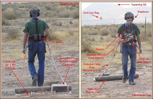
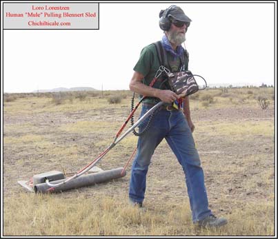
All targets not recognized as modern consumer trash were bagged and tagged. Likewise recorded were the specific details of the target such as the Global Positioning System (GPS) location, depth of burial, time and date, and witnesses present. On occasions when the extracted target was recognized to be significant to the search for the Coronado Expedition and Chichilticale, we recorded the event on video. A modern nail in a plastic container was placed into the excavated hole so that the site could be revisited if needed. The ōBlennert Sledö added to our search speed, accuracy, and coverage more complete than the team had experienced in the previous season. In areas where the sled could not be pulled, such as around mesquite, catclaw, and thick sacaton grass clumps, handheld detectors were employed in a practice that we call ōswinging sticksö and that we considered to be an inferior search technique. The team followed these same procedures during the third field season, although no vegetation clearing was required.8
Nothing is certain in explorationŚeven if you find what you seek you may not recognize it. Professional blacksmith and author Frank Turley of Santa Fe describes identification of historical artifacts as ōeducated guesswork.ö9 Our teamÆs efforts to identify the various artifacts we discovered at Kuykendall Ruins included comparing what we found to photographs of known Coronado artifacts. Flint kindly provided his collection of slides of Coronado artifacts from San Lßzaro Pueblo, Santiago Pueblo (LA 326), and LA 54147, a site about 1,312 feet (400 meters) east of Santiago Pueblo. Archaeologist Deni J. Seymour supplied images from the LA 54147 collection. In addition to these photographic collections, team members consulted photographs of sixteenth-century artifacts featured in books and reports and studied paintings and drawings of such objects. We sent images of our artifacts and, sometimes, the artifacts themselves, to scholars and specialists worldwide.
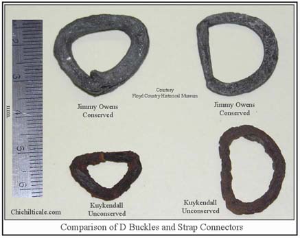
Most critical to identifying artifacts uncovered at the Kuykendall site, however, was comparing them to known artifacts in private and public collections. My wife Karen Brasher and I traveled extensively in order to examine such collections and to seek the opinions of archaeologists and historians who were experts in Spanish-colonial material culture. In February 2006, we visited the Floyd County Historical Museum in Floydada, Texas, where we examined the small portion of sixteenth-century artifacts collected from the Jimmy Owens site, an accepted Coronado site named after its discoverer. From Floydada we traveled to Zuni, New Mexico. At the Zuni Cultural Resource Enterprise, we studied artifacts gathered from Hawikku and Kyakima, places that Coronado occupied or where his expedition was present. In March 2007, at the Florida Museum of Natural History in Gainesville, we examined sixteenth-century artifacts gathered from Spanish sites in Florida and the Caribbean and compared them to our Kuykendall pieces. In St. Augustine, Florida, we pored over the Spanish artifact collection in the Government House Museum. In the Colonial Spanish Quarter, we met private collectors who assessed our Kuykendall artifacts. While in St. Augustine, we examined two substantial private collections, whose owners counseled us on our Kuykendall pieces. We traveled a second time to Zuni in May 2007 to study new artifacts just added to the Zuni Cultural Resource Enterprise collection, and in November 2008 we traveled a second time to the Floyd County Historical Museum to peruse newly added artifacts and to reexamine artifacts we had previously seen.
Our most extensive and comprehensive trip was to South Carolina and Florida in February 2008. Karen and I brought almost all our Kuykendall artifacts to show scholars possessing expertise in Spanish-colonial artifacts dating from the sixteenth to the nineteenth centuries.
In Columbia we saw the Santa Elena collection in the South Carolina State Museum, and examined artifacts and received the counsel of archaeologists at the South Carolina Institute of Archaeology and Anthropology, where the sixteenth-century Santa Elena specimens are curated. We were also granted special access to the sixteenth-century Santa Elena collection at the Parris Island Museum. In Tallahassee, Florida, we met with archaeologists at the Bureau of Archaeological Research who provided us total access to examine sixteenth-century artifacts left by the expedition of Spanish explorer Hernando de Soto at the Governor Martin site and to compare them to our Kuykendall pieces. At Mission San Luis in Tallahassee, the senior archaeologist opened the collection for our examination and comparison. At the Archaeology Institute of the University of West Florida in Pensacola, we studied sixteenth-century Spanish artifacts from Pensacola Bay shipwrecks. We attended the ōWhy St. Augustine?ö program at Flagler College and visited the Lightner Museum in St. Augustine, where experts examined our artifacts. The majority of identifications or suggestions as to identities and ages of the Kuykendall artifacts presented in this narrative were made by archaeologists, curators, and historians (hereafter identified as the ōSoutheasternersö) in South Carolina and Florida.10
Artifacts Discovered at Kuykendall Ruins
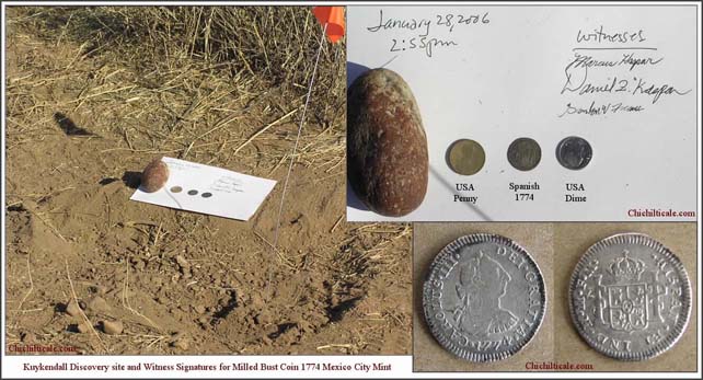
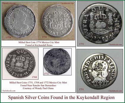
During the initial field season in 2006, the team discovered six artifacts of interest.11 We concluded that four artifacts (a crossbow bolthead, a nail shank, and two awls) likely represented the European contingent of the Coronado Expedition; that one artifact (a Tarascan copper crotal) was possibly left behind by the indios amigos contingent, which was comprised of Natives from central and western Mexico for the expedition; and that one artifact (a 1774 bust coin) signified the post-Coronado Spanish presence at the site. Those artifacts confirmed the Kuykendall site as a genuine place of historical and archaeological interest.
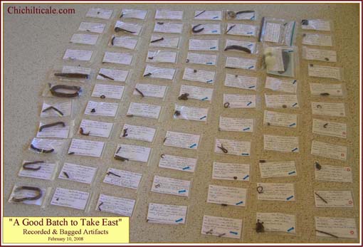
The team discovered many additional metal artifacts of interest during its second and third field seasons. After evaluating the total collection of artifacts uncovered at Kuykendall, team members have concluded that they have found fifty-one individual iron, copper, or pewter pieces that almost certainly, or more likely than not, represent objects left at Kuykendall Ruins by the European contingent of the Coronado Expedition. Another twenty-six artifacts in the assortment may or may not correspond to pieces from the Coronado Expedition. These numbers will almost certainly change as we continue to evaluate the collection. (The nail found during the initial field season has been assigned to the twenty-six piece group.) The team also discovered four lead balls. Three were found very near temporally diagnostic Coronado artifacts. The team uncovered one nonmetal artifact that may be a sixteenth-century piece: a cubic jet bead found beside a metal artifact that is almost certainly a Coronado-era piece.
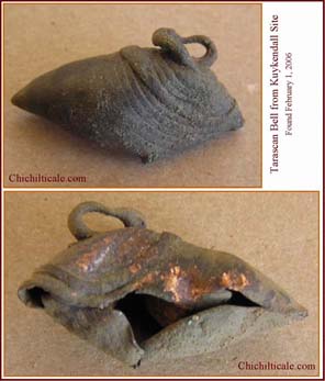
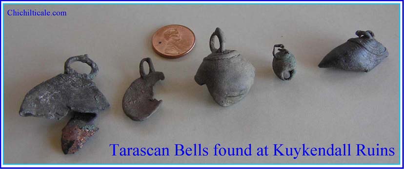
Team members may have found objects left by the Mexican Indian contingent of the Coronado Expedition. My first narrative suggested that some of the indios amigos accompanying Coronado may have carried Tarascan copper crotals. Nine Tarascan crotals or pieces of crotals are known to have been uncovered at Kuykendall Ruins. My team discovered six, the landowner found one, and Jack and Vera Mills found two.12
Another possible indios amigos artifact we discovered is part of a comal (a stone or earthenware cooking surface or griddle) broken into four interlocking pieces. In addition we found numerous pieces of red adobe that almost certainly represent the actual walls of Chichilticale. Among the teamÆs findings as well are four metal objects representing post-Coronado Spaniards and more than a dozen metal pieces that can confidently be dated to the U.S. homestead era between 1888 and 1924.
Map 2 points out the locations of discovered artifacts.
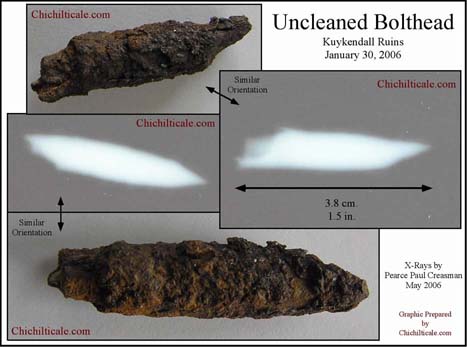
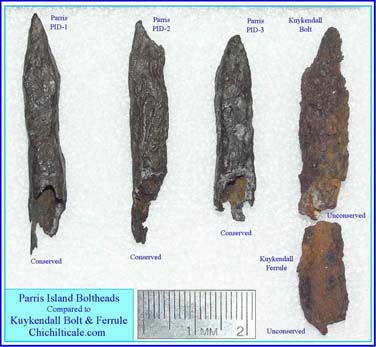
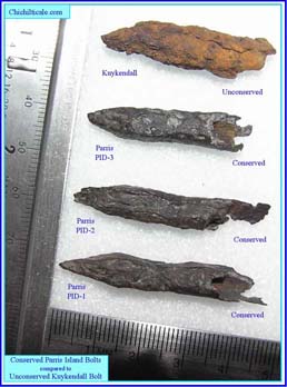
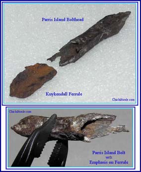
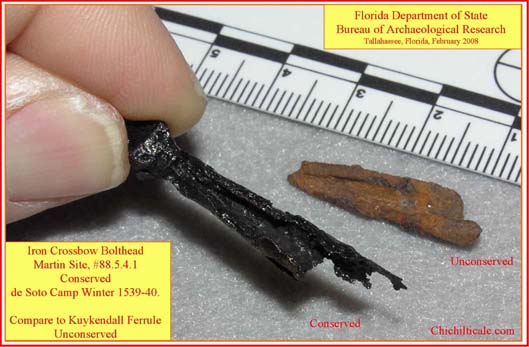
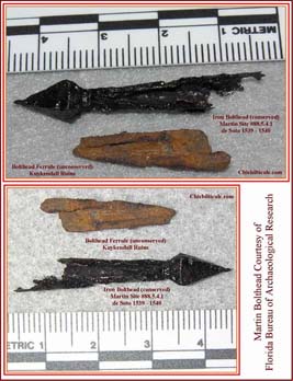
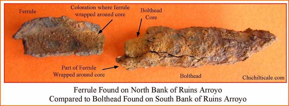
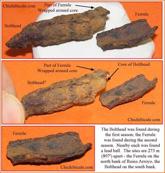
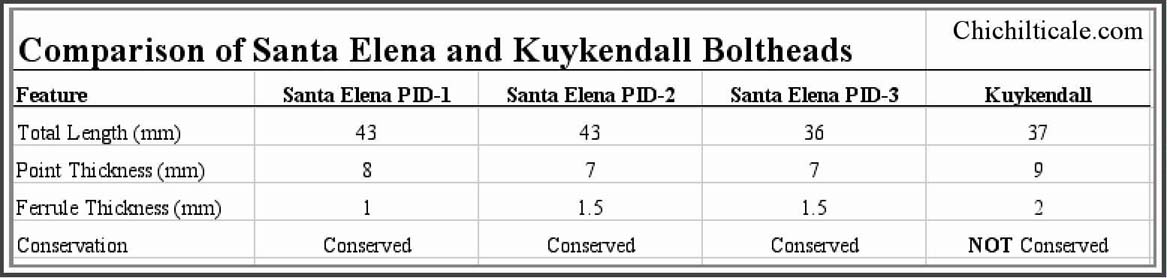
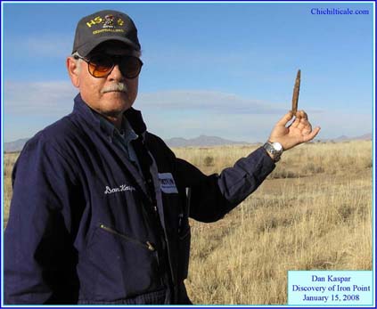
For analytical purposes, I have grouped the Kuykendall artifacts into categories: weaponry, cookware, coins, tools, clothing fasteners, hardware fasteners, chains, buckles, beads, hooklets, awls and needles, copper strips, finials, copper crotals, and buttons. Among the weaponry are pieces of three iron crossbow bolt headsŚa point, a ferrule, and part of a ferrule. These individual pieces, as found, were distinctly separated from each other (see Map 2). Registered petroleum engineer Dan Kaspar found the bolt-head point on the south side of Ruins Arroyo.13 The team recovered the two bolt-head ferrules on the north side of Ruins Arroyo. The crossbow boltheads found in Arizona, I argue, are diagnostic of the Coronado Expedition.14 The following illustrations compare the Kuykendall bolthead pieces with the sixteenth-century boltheads from Florida and South Carolina, as well as illustrate the Kuykendall pieces.
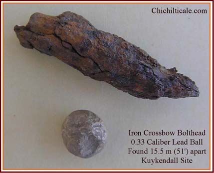
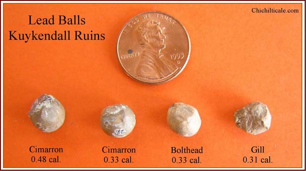
At Kuykendall team members also discovered four lead balls. The spatial arrangements show that two of the three boltheads and three of the four lead balls are locally aligned. The boltheads and lead balls imply the presence of arms-bearing Spanish soldiers of the Coronado Expedition encamped on both sides of Ruins Arroyo.
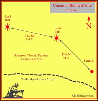
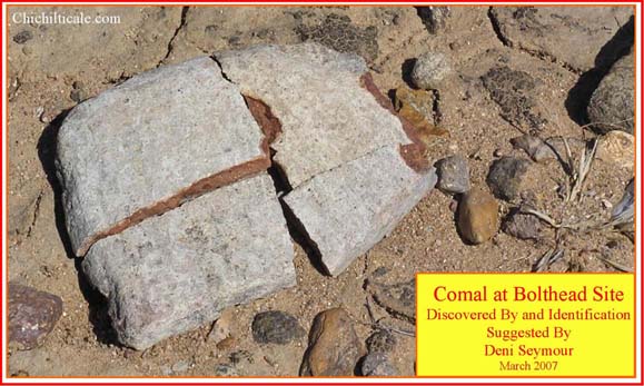
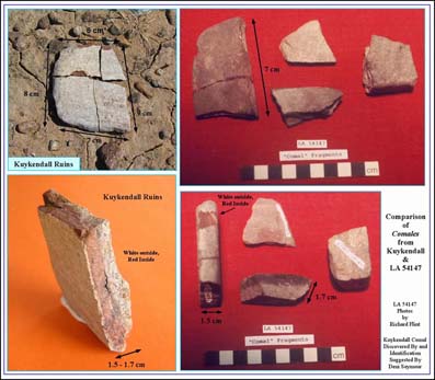
Nearby the weaponry artifacts, we found a lithic artifact that appears to be a comal. We discovered this artifact on the surface a short distance west of the bolthead point in a depression barren of sand and containing five thermal features. Comal fragments had been found by archaeologist Bradley J. Vierra at the LA 54147 site near Santiago Pueblo, New Mexico. Vierra describes the LA 54147 fragments as being composed of thin tabular sandstone; the Kuykendall comal is this same lithology.15 Richard Flint provided me images of comales from LA 54147 that allowed measurements showing very similar thicknesses of the sandstone fragments from Kuykendall and LA 54147. The photographs also displayed the similarity in color, texture and evidence of heating in the Kuykendall and LA 54147 comales. The close proximity of the comal to an iron crossbow bolthead, a lead ball, and five thermal features again suggests the presence of the Coronado Expedition at Kuykendall Ruins.
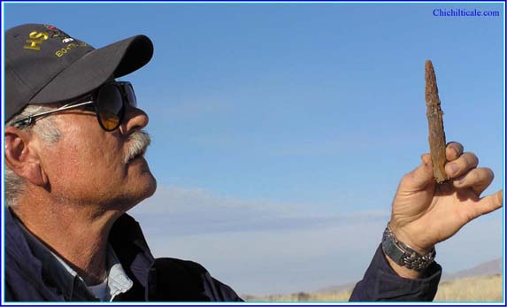
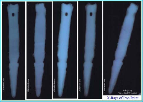
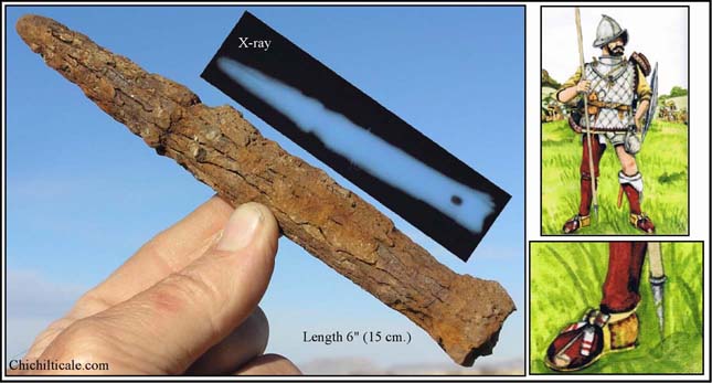
Along the north side of Ruins Plain, Kaspar discovered a severely corroded, wrought-iron point (no. 4 on Map 2). Turley remarked about the corrosion pattern of the piece: ōThe lengthwise separations as a result of corrosion are a pretty good clue that the material is wrought iron, either produced in a bloomery or the larger iron furnace.ö16 Conservator Pearce Paul Creasman at Texas A&M University provided a selection of x-rays of the wrought-iron piece.
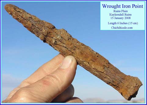
After examining the images, Donald J. La Rocca, curator of arms and armor at the Metropolitan Museum of Art in New York City suggested:
I wouldnÆt think this was a pike head, only because on a pike head proper there are usually side straps extending down from the socket, which help prevent the head from being cut off by opposing infantry or cavalry. It could conceivably be the head of a light lance or javelin, but more likely it is a ferruleŚthe protective cap, often pointed like this, which served to protect the end of the shaft of a spear or light lance, allowing it to be driven into the ground to stand upright, and also allowing the end opposed to the head proper to serve as a crude but effective offensive weapon if necessary. A ferrule is the most likely option in my opinion based on these images. The square holes, as you know, would be for a nail on either side to secure the socket to a wooden shaft. As to date, such a ferrule probably could have been used in the New World in either the 16th century or the 17th.17
Possibly a Spanish soldier from the Coronado Expedition dropped or lost the ferrule on the northern edge of Plains Ruin.
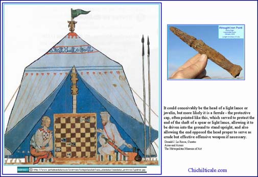
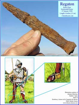
The scholarship of Spanish art historian Pablo MartĒn G¾mez supports the identity of the wrought-iron point suggested by La Rocca. Writing about the Spanish conquistadors of the early sixteenth century, MartĒn G¾mez notes that ōit is most probable that pikes were scarce among the expeditionary forces. . . . In their place, the soldiers went equipped with traditional lances [that were] shorter and more manageable.ö MartĒn G¾mez adds: ōThe lance was much more appropriate than the pike [against] the type of fight natural to the Indians. . . . Easier to carry and much more decisive than the pike, the lance was very popular among the conquistadors.ö18 MartĒn G¾mez describes several polearms, all having certain common attributes, such as a shaft of ash wood with the butt ōreinforced by a regat¾n.ö19 According to MartĒn G¾mez, all polearms ōhad the inferior extreme [butt of shaft] protected by a regat¾n.ö20 The regat¾n mentioned by MartĒn is what La Rocca calls the ferrule.
Spanish-colonial arms historian Walter Karcheski Jr. offers still more evidence for lances. He writes: ōSpanish horsemen in the New World carried lances. . . . It is likely that Colonial lancers used a lighter form of weapon. . . . [In] fact, some of the lances may have been like the javelins (jinetas) of the Spanish light cavalry (ginetes). Spanish accounts can be somewhat confusing regarding the differences between lances and pikes, for the terms are often used interchangeably.ö21 Flint has provided me with Spaniard Bernardo Vargas MachucaÆs description of one of the functions of a regat¾n: ōWhen an armed soldier sallies forth, he takes the horse and is armed at the same time with his weapons. He thrusts the lance into the ground near the horse, so that upon mounting he can grab it.ö22
The written record of the Coronado Expedition supports G¾mezÆs contention that the Spaniards carried lances, not pikes. The word lanza (lance) is spelled lanńa in the Coronado documents. In his record of the Coronado Expedition, Pedro de Casta±eda de Nßjera describes how Spaniards, shouldering their ōlanńas,ö departed Culiacßn on foot, not on their horses, which were carrying supplies.23 He also relates three accounts of horsemen using lances. On the Great Plains, Spanish horsemen killed rabbits, found in great abundance, with their lances.24 Casta±eda recounted that, when the party of Melchior DĒaz was attacked at the RĒo del Tiz¾n (RĒo Colorado between Arizona and California), Spanish horsemen chased the Indians and injured them with their lances.25 These accounts testify to the manageability of the lance and suggest that Spaniards on the expedition favored it over the pike.
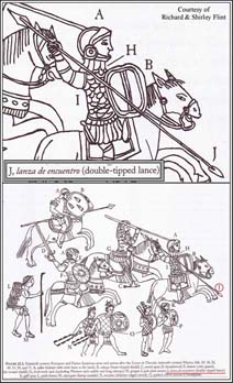
The death of Melchior DĒaz offers compelling evidence that the lances on the Coronado Expedition were equipped with a regat¾n. Casta±eda wrote: ōOne day a lebrel [a swift, short-haired dog used to hunt rabbits] brought by a soldier fancied to [chase] some sheep brought along for food. When the captain saw this, he hurled his lanńa de enquentro at it as he was galloping. [The lance] stuck in the ground. Not able to stop his horse, [DĒaz] ran onto the lance and it pierced [him] through his thigh, and the iron went all the way through his groin and broke his bladder.ö26 This account illustrates that the ōlanńa de enquentroö carried by DĒaz had an ōironö regat¾n on the butt of the shaft. Coronado scholars Richard Flint and Shirley Flint refer to the ōlanńa de enquentroö as a ōdouble-tipped lanceö in an illustration of the arms and armor of the Spaniards and indios amigos in their published collection of Coronado documents.27
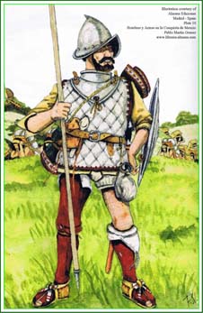
The Pablo MartĒn G¾mez illustration is used to display the Kuykendall iron artifact in comparison with a sixteenth century soldado de infanterĒa (infantry soldier) holding a lance with a regat¾n attached to the butt-end of the shaft.28
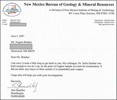
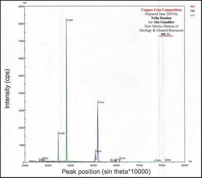
The team discovered one copper coin (no. 32 on Map 2). Initially the artifact was so tarnished and disfigured that team members thought it was a scrap of tin can, but when they realized that the piece was not magnetic, I cleaned it and saw the copper color. To learn if the metal was brass, I sent the piece to metallurgist Abe Gundiler at the New Mexico Bureau of Geology. After his examination of the artifact, he reported: ōMy colleague, Dr. Nelia Dunbar, was kind enough to run an x-ray on the piece of copper sample you sent for examination. It did not show any traces of other metals; it is remarkably pure copper.ö29
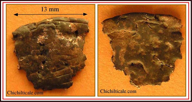
The identity of the piece remained a mystery until collections specialist James B. Legg of the South Carolina Institute of Archaeology and Anthropology examined it. He suggested that the artifact was a coin, a possibility that the team had not considered. Alan M. Stahl, curator of Numismatics, Rare Books, and Special Collections at the Firestone Library of Princeton University, next studied the copper piece. After his inspection, Stahl wrote:
I have examined the fragment, and to the best of my judgement, it appears to derive from a copper cuarto of Spain of Ferdinand and Isabella, issued between 1497 and 1504. . . . Issues bearing the names of the monarchs were continued after the death of Isabella in 1504, and even after that of Ferdinand in 1516. . . . The diagnostic aspects are what appears to be the crown on the lionÆs head on the obverse and the parallel lines that mark the bottom of the castle on the reverse.30
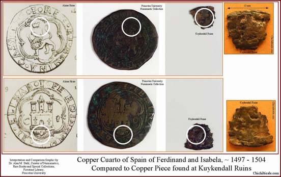
The copper piece found at Kuykendall, if it is indeed a Spanish cuarto, helps confirm the brief Spanish presence at the ruins site in the sixteenth century.31 Coins, including cuartos, have been found at other early Spanish-colonial sites such as the Jimmy Owens site in Texas, the Governor Martin site in Florida, the Columbus village at La Isabela in the Dominican Republic, and the settlement of Puerto Real in Haiti.32
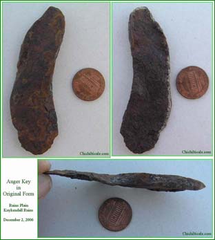
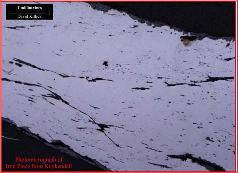
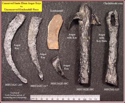
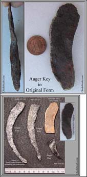
At the Kuykendall Ruins site, the team discovered three artifacts that appeared to be metal tools. First, an iron piece, possibly an auger key, was found on the north side of Ruins Plain (no. 3 on Map 2). From his photomicrographic analysis of the artifact, archaeologist David Killick at the University of Arizona concluded: ōThe piece is definitely bloomery iron . . . full of slag (the dark stringers within the bright iron). . . .[Slag] is never seen in iron produced in a blast furnace. Any iron used in the Coronado expedition would have been bloomery iron.ö The diagnostic limitation of this artifact, Killick notes, is that bloomery iron was ōused for a long time [after Coronado], though I doubt that there would have been much circulating in Arizona after about 1860.ö Killick declared that neither he nor other scientists can physically or chemically ōdateö the iron piece ōmore precisely.ö33
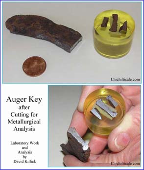
James B. Legg at the South Carolina Institute of Archaeology and Anthropology provided a compelling photograph comparing the Kuykendall piece with auger keys found at sixteenth-century Santa Elena.
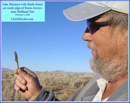
Two other iron tools were discovered on opposite sides of Ruins Arroyo near the bolt-head locations (nos. 18 and 26 on Map 2). Some of the Southeasterners suggested that the one tool might be a pod auger (tool for boring small holes in wood) or a graver (cutting or shaving tool for wood). Discovered by Blennert, the other tool is a blade.
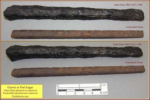
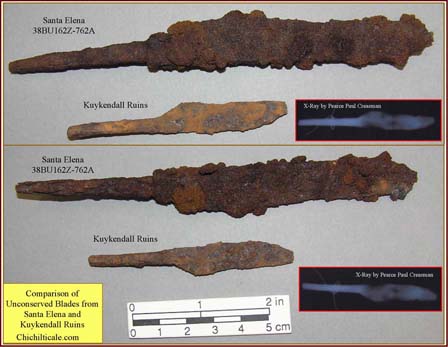
These three artifacts ¢ auger key, pod auger, and blade ¢ represent types of tools found in Spanish colonial sixteenth-century collections.
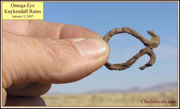
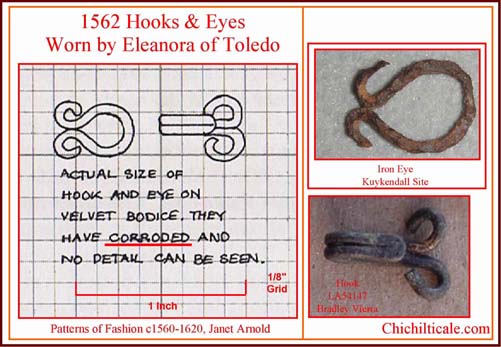
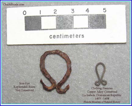
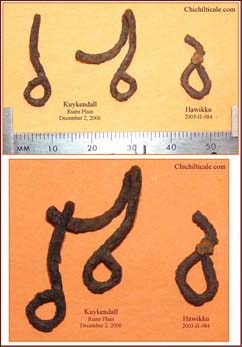
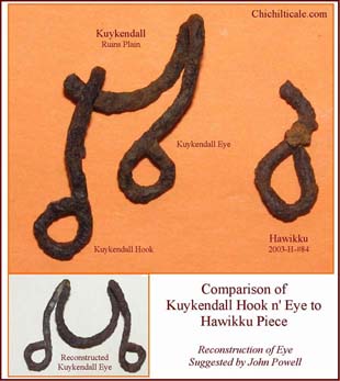
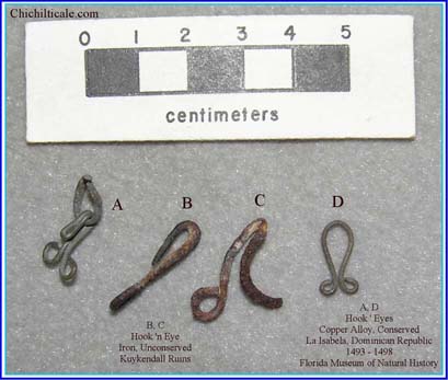
The teamÆs exploration at Kuykendall yielded three clothing fasteners (nos. 1 and 2 on Map 2). One is an omega-shaped iron eye of a hook-and-eye fastener that compares well to such a fastener on a clothing item dated about 1615.34
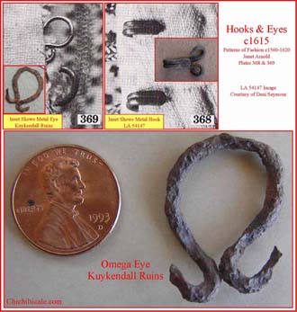
The two other clothing fasteners discovered on Ruins Plain at Kuykendall comprised a hook-and-eye set. When found, the two pieces were touching one another. A similar iron piece was found at Hawikku. The presence of comparable garment fasteners at locations over two hundred miles apart, with one being an accepted Coronado occupation and battle site, is at the very least suggestive of similar clothing at the two locales.
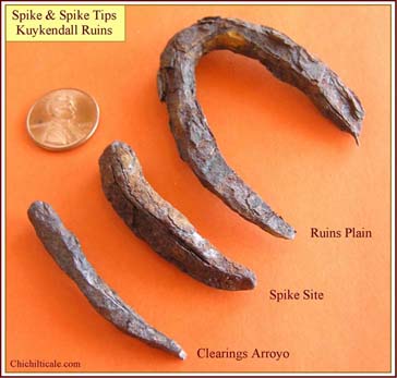
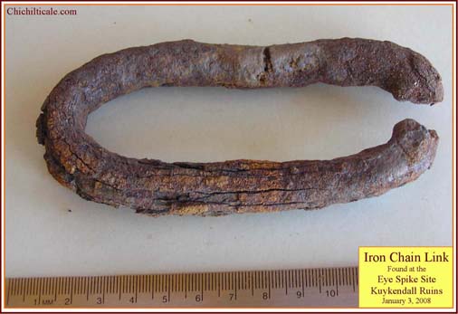
At Kuykendall Ruins, the team found seventeen iron objectsŚspikes (nos. 9, which includes a spike tip plus two pieces; 14; and 35 on Map 2), an eye spike (no. 15), nails (nos. 22, 24, 25, 28, and 36), a tack (no. 37), fasteners (nos. 20, 21, and 27), and staples (nos. 23 and 40)Śthat, we believe, are related to the Coronado Expedition.
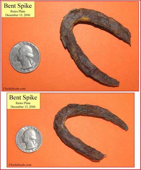
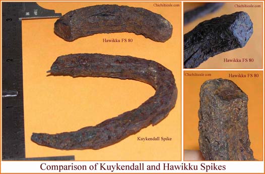
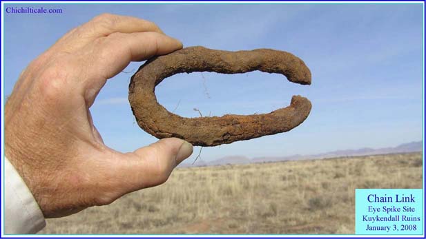
Five of the pieces represent spikes or parts of spikes. During the second field season we discovered an isolated, almost complete spike, (no. 14 on Map 2) bent into a form that initially appeared to be a chain link. However, the Southeastern archaeologists immediately recognized the piece as a spike and wondered why it had been bent in such a manner. The Hawikku collection also contains part of a similar spike. As with the garment fasteners (nos. 1 and 2 on Map 2), comparable spikes discovered at Hawikku and Kuykendall Ruins suggests that the same party, likely the Coronado Expedition, dropped them at both sites.
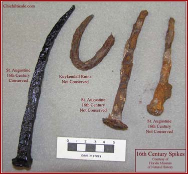
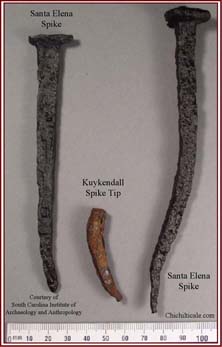
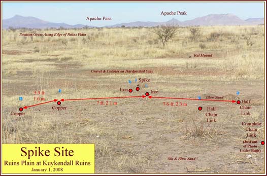
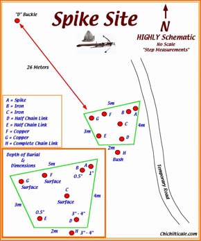
A short distance north of this isolated spike, the team found three iron pieces (no. 9 on Map 2). Several Southeasterners identified one of the iron pieces as the tip of a spike. Two other iron pieces, almost touching the spike tip when found, are likely parts of the same spike. Therefore, we call this area the Spike Site. The Kuykendall spike tip is comparable to the points of two spikes recovered from the sixteenth-century Santa Elena site, and is likely similar in age.
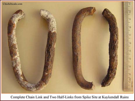
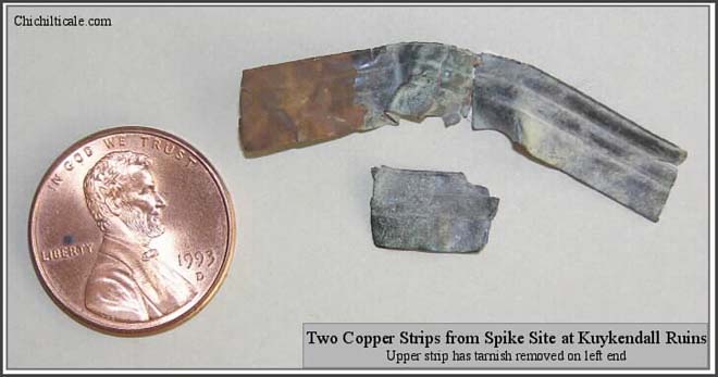
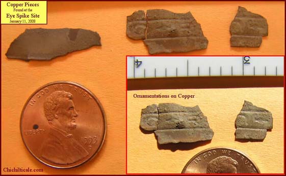
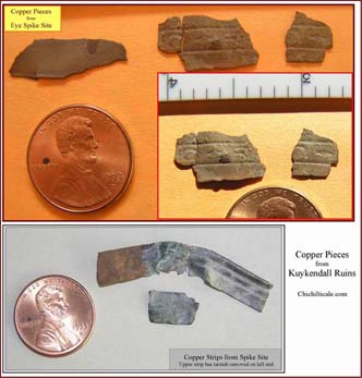
Within just steps of these three iron pieces, we found three chain links (nos. 8, 10, and 11 on Map 2) and two copper strips (no. 13 on Map 2).
These finds represent a cluster of distinct artifact types that are likely sixteenth-century in age.
To the west, on the south side of Clearings Arroyo, Gordon Fraser found the tip of yet another iron spike (no. 35 on Map 2). The find by Fraser increased our spike tip find to three.
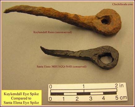
In an area the team calls the Eye Spike Site, members uncovered a single wrought iron artifact (no. 15 on Map 2) first identified by Turley as an eye spike.35 The Santa Elena collection includes an almost identical piece.
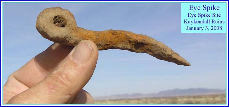
The Eye Spike Site contained associated artifacts remarkably similar to those found at the Spike Site. A few steps away from the eye spike, the team found three copper strips (no. 17) and a wrought iron chain link (no. 16). The Eye Spike Site represents another cluster of distinct artifact types probably from the sixteenth-century.

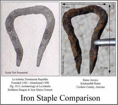
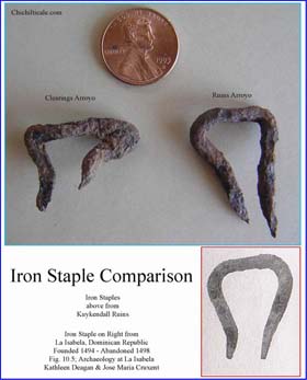
South of the Eye Spike Site is an area of concentrated artifacts we named the Ruins Arroyo Site. There searchers found two iron ellipsoid-shaped fastening nails (nos. 20 and 21). These artifacts appear to be attachment staples for cotter-pin chest hinges like those found at La Isabela in the present Dominican Republic. In 1494 the Spanish founded La Isabela, the first European settlement in America, and abandoned it in 1498.
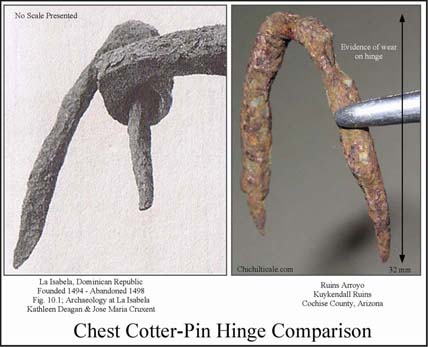
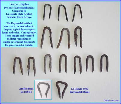
Near the two attachment staples, John Blennert discovered another type of iron staple (no. 23) similar to an artifact found at La Isabela.36 On the north side of Clearings Arroyo we found a second example of this staple (no. 40).
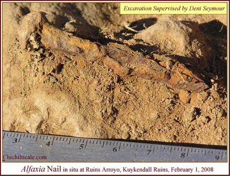
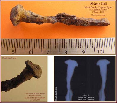
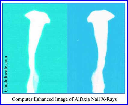
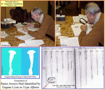
Also recovered at the Ruins Arroyo Site were three distinct nail types in close proximity to the hinge-fastening nails and the iron staple. Southeasterner Eugene Lyon, a nail expert, identified one of the pieces as an alfaxia nail (no. 22 on Map 2) consistent with sixteenth-century examples found at Santa Elena and with late fifteenth ¢ early sixteenth century nails shown on a drawing from the Archivo General de Indias, Seville.
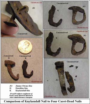
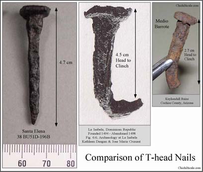
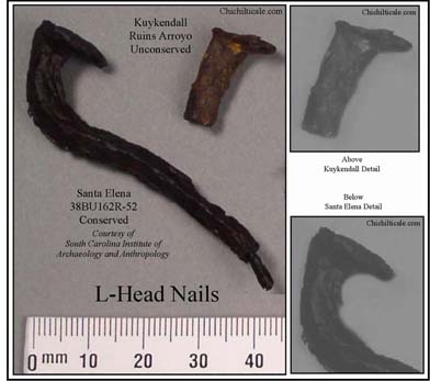
Nearby the team found a T-head nail (no. 24 on Map 2) similar to sixteenth-century medios barrotes excavated at both La Isabela and Santa Elena. A few steps away, Blennert discovered an L-head nail (no. 25 on Map 2) mirroring artifacts discovered at Santa Elena.
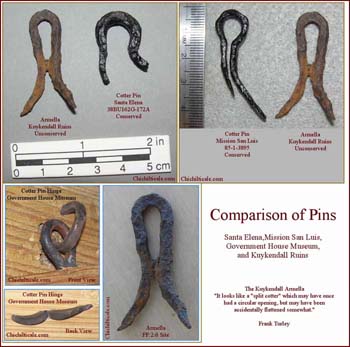
The team at Kuykendall discovered a fastener and a nail at the archaeological site, FF:2:6, east of the ruins. One iron object (no. 27 on Map 2), excavated on the western edge of the buildings, looked at first glance like an unusual fence staple, but an examination of the artifact in photographs led Turley to comment: ōIn Spanish, it is an armella. It looks like a æsplit cotterÆ which may have once had a circular opening, but may have been accidentally flattened somewhat. Because of the diminutive size, it could have been used on wooden furniture.ö37 During our travels in the Southeast, Karen and I saw examples of armellas and cotter pin hinges in collections at Santa Elena, Mission San Luis, and the Government House Museum.
East of the armella , Blennert discovered an almost complete horseshoe nail (no. 28) similar to a Hawikku specimen.
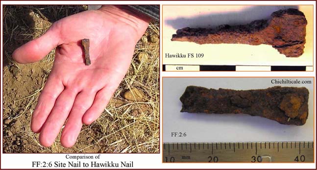
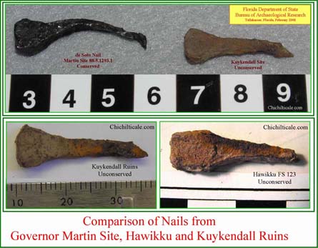
On the far west side of the explored area and on the south side of Clearings Arroyo, team members found a wrought-iron horseshoe nail (no. 36) of a type found at the Governor Martin site and at Hawikku.
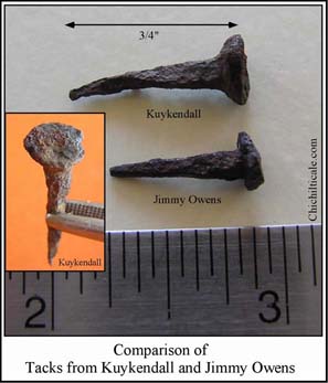
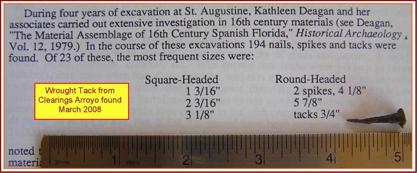
A short distance away on the north side of the arroyo, we discovered a round-head, wrought-iron tack three-quarters inch (1.9 cm) long. This type and size of tack (no. 37) was the most frequent tack found by historical archaeologist and sixteenth-century specialist Kathleen Deagan in her four years of excavations of sixteenth-century materials in St. Augustine, Florida.38 The Jimmy Owens collection at the Floyd County Historical Museum contains an almost identical tack . Within inches of the tack the team found the shank of a wrought nail, but the item has not been included with the collection of likely Coronado artifacts.
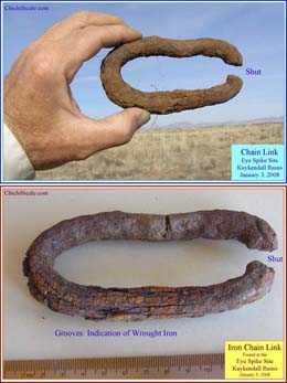
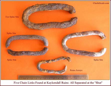
The team found a total of six chain links (nos. 8, 10, 11, 12, 16, and 19). Three of these were discovered at the Spike Site (nos. 10, 11, and 12). One is a complete, round, wrought-iron chain link separated at one end (no. 10). Turley studied photographs of this artifact and described the process of forging chain links in the Iron AgeŚthe process CoronadoÆs smiths followed:
ōThe links were always forge welded (hammer welded) on the end, not on the long side. Sometimes the weld will show as slightly incomplete on the surface of the piece. It appears as a æseamÆ which we, as smiths, call a æshut.Æ A forge weld may not be quite as strong as the parent stock, so there is the possibility of breakage on the end, especially if the weld was performed by a neophyte.ö39
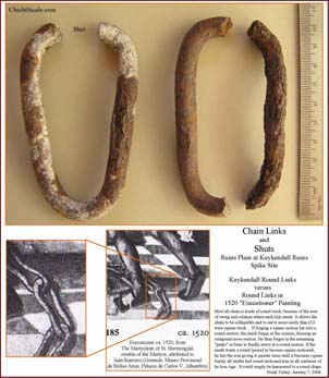
The complete chain link found at the Spike Site was separated at the ōshutö as Turley describes. The team discovered two half links (nos. 11 and 12) at the Spike Site; the fit of their broken ends indicates that they may have originally been the same complete link. The close proximity of the links to the probable sixteenth-century spike tip and the method of fabricating the links strongly suggest that the chain links are also sixteenth-century material left by the Coronado Expedition.
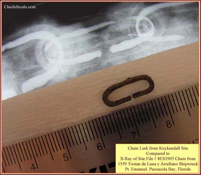
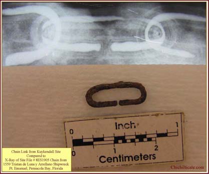
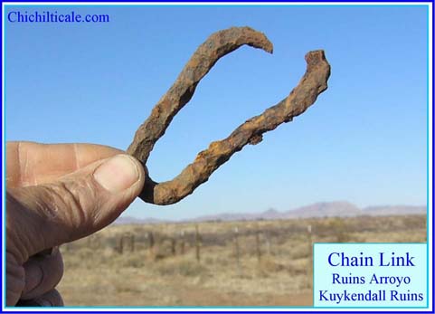
The team located another intriguing chain link. A short distance from the large chain links at the Spike Site was discovered a small iron chain link (no. 8) distinguished by a gap on one side. Archaeologists retrieved a similar gapped chain at the site of the Tristan de Luna y Arrellano, a 1559 Spanish shipwreck (8ES1905) at Emanuel Point in Pensacola Bay, Florida.
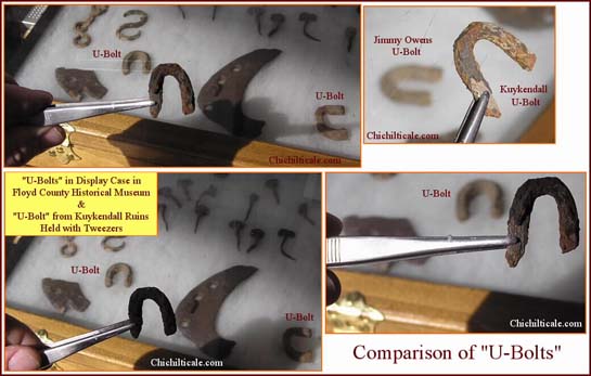
Near the gap-chain link and the Spike Site, we found what appeared to be a chain link broken in half to create a ōU-shapedö iron object, but since we were at a loss to explain how such a break could occur in a chain, we suspected that the object might be part of a staple. There are two such pieces in the display case of Coronado artifacts at the Floyd County Historical Museum. Despite the presence of these ōU-shapedö artifacts at both Kuykendall Ruins and the Jimmy Owens site, we are not currently including this Kuykendall piece in our collection of fifty-one suggested Coronado artifacts.
At the Eye Spike Site team members discovered a large, severely corroded, wrought iron chain link (no. 16) separated likewise at the shut. The lengthwise separations, or grooves, similar to those seen on the regat¾n indicate that the piece is wrought.
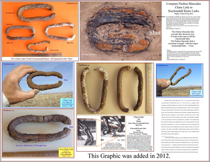
Near the graver, or pod auger, along the north bank of Ruins Arroyo, we found a chain link separated at the shut (no.19).
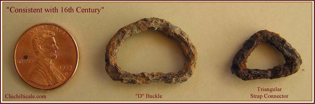
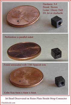
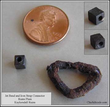
In the course of our exploration, the team discovered two buckles and one bead south of Clearings Arroyo. One buckle was an iron ōDö buckle (no. 7); the other was a triangular-shaped, iron piece identified as a strap connector (no. 5). Both pieces, according to several Southeasterners, are consistent with sixteenth-century buckles uncovered in their region. The Jimmy Owens collection in the Floyd County Historical Museum contains an example of each of these two artifacts. Three steps from the strap connector, the team found a perfectly symmetrical, cubic jet bead (no. 6). None of the five specialists consulted had ever seen a bead exactly like the one found at Kuykendall Ruins.40 The cubic form is unusualŚthe more common sixteenth-century jet beads are pyramidal-shaped with rectangular to square bases, or are faceted on multiple sides like those found on two Spanish-colonial sites in Belize.41 Despite this anomaly, none of the five excluded the possibility that the Kuykendall bead could be a sixteenth-century artifact, especially given its jet composition and its proximity to the strap connector. Deagan notes that ōlapidary beads were present in the New World as early as 1511,ö and that ōjet was used in Spain from the sixteenth-century onward for pendants as well as for beads, and was particularly popular for use in rosaries and for other religious and magical items.ö42
On the north side of Clearings Arroyo were found four of the most perplexing artifacts discovered at Kuykendall. The team referred to them as ōhooklets.ö Three hooklets (no. 38) had been lost within a few steps of one another and were unearthed directly beside a pile of fired rocks. Another hooklet (no. 39) was found a short distance away. One Southeasterner suggested that these objects are broken buckles that had been used to tighten leather straps, the equivalent of a modern Conway buckle. Within just steps of the isolated hooklet, we found an iron staple of the La Isabela style (no. 40). Because of the proximal association of the staple and hooklet, and the presence of dozens of thermal features, the team believes that all the hooklets are more likely than not from the sixteenth century.
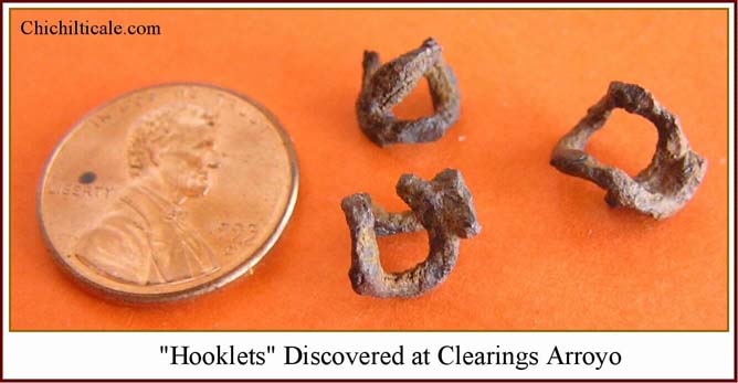
The team made other discoveries in this immediate area. Within a few steps, we found two small tacks, two small wrought nails, and a small wrought ellipsoid-shaped fastener. Although these five additional artifacts may indeed be sixteenth-century in age, we hesitate to include them in our Coronado-artifact count.43 All these items were found in an area of high concentration of thermal features.
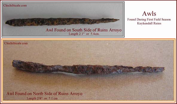
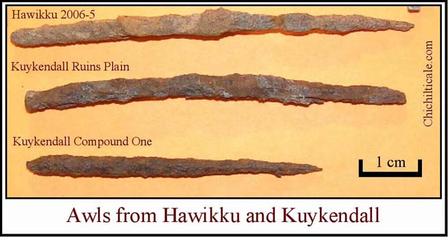
Two iron awls and one iron needle, all likely sixteenth-century artifacts, were discovered at Kuykendall Ruins. Found during the initial field season and described in my first narrative, the two Kuykendall awls (nos. 29, 31) are similar to a sixteenth-century awl recovered at Hawikku.44 The Ruins Plain awl is similar enough to the Hawikku specimen in length and form to suggest a common origin.
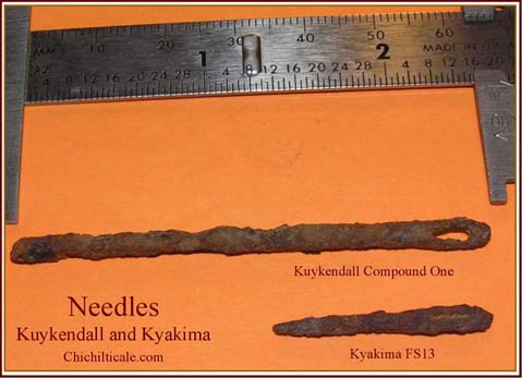
The needle (no. 30) is comparable to an iron needle, FS13, found on the Kyakima site at Zuni and described by archaeologist Jonathan E. Damp.45 The width of the needle eye of FS13 is 0.37 centimeters and of the Kuykendall needle, 0.40 centimeters; the thickness of the eye of FS13 is 0.25 centimeters and of the Kuykendall piece, 0.2+ centimeters; the eye length of FS13 is 0.5 centimeters and of the Kuykendall needle, 0.7 centimeters; the eye of FS13 begins 0.35 centimeters from the head of the needle and of the Kuykendall needle, 0.3+ centimeters from the head. These measurements show needles quite similar in size and shape, and suggest that they share a common origin with the Coronado Expedition.
Our team found five copper strips in two distinct groups. Two strips (no. 13) were discovered almost touching each other at the Spike Site and three others (no. 17) were found within inches of one another at the Eye Spike Site. The Eye Spike strips are ornamented. Southeasterners observed that all the copper strips are unfinished on one side and suggested that they were part of the sheeting or lining for a box or chest, or even for saddle ornamentation. Although the striations are quite similar to those on a hawk bell in the collection at Mission San Luis in Tallahassee, Florida, and on two copper bells found at Santiago Pueblo Site LA 326, the Southeasterners did not believe that the Kuykendall strips are parts of a bell. Given that the copper strips were recovered in proximity to the spike tip and chain links at the Spike Site and to the eye spike and chain link at the Eye Spike Site, the strips are likely sixteenth-century artifacts.
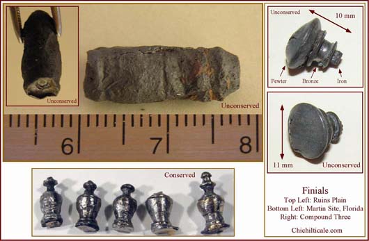
Other likely artifacts left by the Coronado Expedition at the Red House site are two objects identified by the Southeasterners as finials. More than nineteen finials were found during the excavation of De SotoÆs winter camp at the Governor Martin site in Tallahassee, Florida.46 The one found at Compound Three (no. 33) consists of a hollow pewter cap atop a bronze collar through which an iron shaft was attached. The Southeasterners suggested it might be a lid top, a pull knob for a small case, or a horse-tack ornament. The other finial (no. 34), found on Ruins Plain, is unusual in that although it is magnetic and therefore likely iron, it is unexpectedly heavy and produces a lead image when x-rayed. Its function remains a mystery.
During our three seasons of exploration at Kuykendall Ruins, we found five Tarascan copper crotals and one piece of a crotal. Three crotals were discovered before we arrived. The origins of these bells are unclear. These crotals may have arrived at Kuykendall with the Tarascan Indian component of the indios amigos, or Native traders may have carried these crotals north from Mexico prior to CoronadoÆs entrada into the region. Although the team cannot ascribe the bells to the Coronado Expedition with certainty, their anomalously abundant existence at Kuykendall Ruins suggests that a Native trade route came by the Red House. Historians believe that Coronado followed a pre-existing Indian trail running between northern Mexico and the Rio Grande Valley, implying that Kuykendall Ruins is situated along a possible Coronado route.
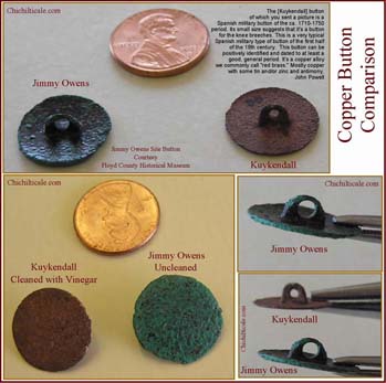
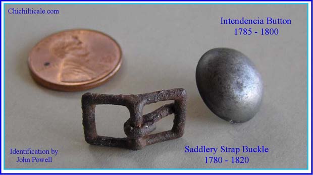
The teamÆs exploration efforts produced four metal artifacts that are almost certainly post-Coronado in age. My first narrative reported the discovery of a 1774 Spanish coin (no. 43).47 The following season, the search turned up a copper button (no. 44). The examination of a photograph led John Powell, an expert in military buttons and buckles, to conclude that the artifact is ōa Spanish military button of the ca. 1710¢1750 period,ö ōa [small] button for the knee breeches,ö and a button ōvery typical . . . of the first half of the 18th century.ö The primary material is ōa copper alloyö known ōcommonlyö as ōæred brass,Æö which is ōmostly copper with some tin and/or zinc and antimony.ö48 The Jimmy Owens collection at the Floyd County Historical Museum contains a button almost identical to the one found at Kuykendall Ruins.
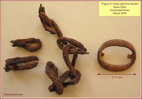
Near the end of the third field season, the team found a cast-iron oval buckle (no. 41) and an associated wrought-iron chain (no. 42) along the north edge of Ruins Plain. Only two steps separated the chain and buckle. Ten individual links of chain were ultimately discovered. Six links comprise the longest piece of chain. Nine of the ten links were wrought as figure eights. Powell suggests that the size of the oval buckle and its cast-iron crafting indicate that it belonged to a saddlery strap used during the 1780¢1820 period.49 The shape of the links and their proximity to the saddlery buckle leads us to conclude that the chain was likely part of a rein chain from the same period.
We found more than a dozen objects that date from 1888 to 1924 and almost certainly represent the homesteaders who inhabited the site.
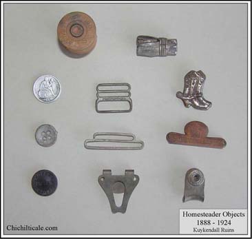
There are remains of three homesteader houses in or near the areas we metal detected. We purposely avoided disturbing these locations; the homesteader objects we found were not associated with the houses.
Due to constraints on manuscript length, this ōPost-Coronado Presenceö section, as published in the New Mexico Historical Review, is unavoidably much abbreviated from the material I submitted. Readers interested in the more comprehensive account, which includes maps, photographs of actual places named in historical documents, and additional written information and translations, are encouraged to consult the website section titled ōPost-Coronado Presence in Region.ö
For the four hundred years after Coronado left Chichilticale in 1542, the Sulphur Springs Valley remained a remote region seldom visited by outsiders.50 In 1913 geologists Oscar Edward Meinzer, F. C. Kelton, and Robert Humphrey Forbes declared that until the mid 1870s, Sulphur Springs Valley ōwas occupied almost exclusively by the [warlike] Chiricahua Indiansö and ōwas avoided by the Spanish explorers and missionaries and later by Mexican and American prospectors and settlers.ö51 The map created by Jesuit priest Juan Nentvig in 1762 supports the claim of Meinzer, Kelton, and Forbes since it shows the Sulphur Springs Valley region obviously empty except for the Chiricahua [Chiguicagui] Mountains.52 According to anthropologist Edward H. Spicer, six or more tribes of Indians occupied this region. The tribes included the Sumas and Jocomes, the latter ōpossibly a band of what later came to be called Arivaipa or Chiricahua Apaches.ö Still, the country north of the OpatasÆ agricultural settlements in northeastern Sonora was ōa no manÆs landö at least for Euroamericans between 1650 and 1870.53
A historical summary of non-Native activity in the Sulphur Springs Valley prior to the early 1870s is warranted for the purpose of demonstrating the overwhelming lack of Spanish, Mexican, or American settlement or presence following the Coronado Expedition. In the early 1680Æs trouble increased between the Sumas and the Spaniards. During the spring and summer of 1684, the Suma Revolt at Janos and Casas Grandes spread to Indians to the east and to the south but did not expand west of the Janos mission, destroyed during the revolt, to the Sulphur Springs Valley. Subsequently, the Spanish established a presidio at Janos in 1686 and another one at Fronteras in 1692. In 1695 the murder of the Jesuit priest Francisco Xavier Saeta by rebellious Pimas at the new mission in Caborca and the SpaniardsÆ retaliatory killing of forty-nine Natives attending a peace talk triggered a revolt by the Pimas. In response the Spanish governor of Nueva Vizcaya ordered a full-scale military campaign into the region.54 The four-month operation was recorded by one of the commanding officers, Juan Fernßndez de la Fuente of Janos Presidio, who described the Spanish penetration of the Sulphur Springs Valley during mid September 1695.
My translations of the record for FernßndezÆs whereabouts in September leads me to conclude that from QuĒburi the Spanish presidiales and their Indian allies most likely crossed the Dragoon Mountains at their south end (alternative routes include Middlemarch Pass and South Pass) and, marching almost due east, passed south of Squaretop Hills and just north of the Swisshelm Mountains to reach a camp ōin this arroyo that leaves the Chiricahua sierraö on Thursday, 15 September 1695.55 On the nineteenth, Fernßndez relocated his camp to ōa large waterhole three leagues to the north.ö56 The troops scouted from this second encampment until 24 September 1695, when FernßndezÆs expedition broke camp, traveledŚin FernßndezÆs wordsŚōmore than six leagues to the north over flat landö along the western slope of the Chiricahua Mountains, marched east through ōel Puerto de San Felipeö (present-day Apache Pass), and made camp at the mouth of Siphon Canyon.57
Assuming this route is correct, I can place the locations of the two FernßndezÆs camps (15¢18 and 19¢24 September) on the western side of the Chiricahua Mountains south of Apache Pass. His camp of 19¢23 September was probably on modern Ash Creek or extinct Ruins Arroyo at a location about eight miles (13 km) east of Kuykendall Ruins. Three leagues farther south, his camp of 15-18 September stood on Whitewater Draw at Rucker Canyon.
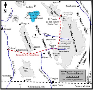
If my interpretation is correct, the Kuykendall Ruins site was not an encampment for the Spanish military campaign of 1695 in the Sulphur Springs Valley. Moreover, Fernßndez reports that excursions by his troops from those September camps advanced to the north, not the west, suggesting that Spanish horsemen paid no visits to Kuykendall Ruins. The Spanish artifacts the team found at Kuykendall Ruins are not likely the remains of FernßndezÆs expedition in 1695.
In December 1696, Padre Eusebio Francisco Kino first visited Christianized Indians in the QuĒburi region along the RĒo San Pedro near modern Fairbank, Arizona. A year later he described the country along the RĒo San Pedro as ōpleasant and fertile . . . though much harassed by the Jacomes and Apaches in the east.ö By 1705 the Spaniards began referring to the raiding Indians as Apaches. They controlled the territory from the Opata villages in Sonora to the pueblo of Zuni in New Mexico. These Native groups either completely blocked or radically slowed all Euroamerican settlement in their homeland until the early 1870s.58
By 1710 fighting between the Apaches and the Spaniards was so intense that the northern limit of Spanish settlement stood at Janos and Fronteras south of the modern border between Mexico and the United States. According to Spicer, the Spaniards withdrew from the sprinkle of ōranches and mining settlements . . . north of this line.ö (It is unlikely that the Kuykendall Ruins site supported one of these early ranches.) These abandonments helped create the ōApache Corridor,ö a ōstrip of territory nearly 250 miles wide, roughly from Casas Grandes to Zuni,ö without any Spanish dominion. Travel across the corridor, even ōwith full military escort,ö was extremely dangerous. Wagoner suggests, ōAfter KinoÆs death in 1711 there is no record of a Spaniard having entered Arizona for twenty years.ö59
Spanish efforts to gain control of the 250-mile gap were unsuccessful during the first seventy-five years of the eighteenth century. In January 1721, Lieut. Juan Bautista de Anza of Sonora accompanied a group of citizen militia, Opata Indians, and three or four Spanish soldiers from Bacoachi against the Apaches in the Chiricahuas. This Spanish campaign and others that followed were generally inconclusive, and the Apaches reacted by increasing their raids against Spanish haciendas as far south as central Sonora. To impose some military check, the Spaniards established a presidio at Terrenate on the headwaters of the RĒo San Pedro in 1741 and another at Tubac on the RĒo Santa Cruz in 1752. These isolated military outposts still failed to decrease Apache depredations.60
Although I have found no written evidence of a Spanish presence at Kuykendall Ruins between 1542 and 1750, the team found a copper military button dated to the period from 1710 to 1750. If that button arrived at the site with a Spaniard rather than a Native American, at least one Spanish excursion visited the location during that time. Given the historical record, it seems that the button most likely appeared at Kuykendall Ruins between 1710 and 1724, during which the Spanish compa±ias volantes (flying companies) remained active north of the modern international border. Afterward, Spanish policy sharply reduced their offensive operations in apacheria, the Apache homeland. By the early 1760Æs the Apaches had driven out the last Sobaipuris living along the RĒo San Pedro. On the northern frontier, the Spaniards mounted some successful offensive operations but generally lived behind ōgreat walled forts,ö around which the Apaches moved at will.61
Attacks and counter-attacks were the norm until 1786 when the Spaniards initiated a policy of negotiating peace treaties with individual bands of Indians. A part of the ongoing Bourbon Reforms launched in the 1760s by King Carlos III to restructure and re-energize the Spanish Empire, this peace policy also settled willing Apaches at establecimientos de paz (peace establishments), where the Spaniards supplied them and protected them from other Native enemies, especially Comanches from Texas. The policy successfully kept the peace with the Apaches well into the 1810s, when the unrest of the Mexican independence movement began to disrupt the programÆs funding and logistics.62
The relative peace between Spaniards and Apaches helped to open communications between Sonora and New Mexico. According to historian Alberto Suarez, Spanish merchant Esteban Gach, headquartered in Arizpe, ōtraded regularly with New Mexico.ö Anthropologist Jack S. Williams notes that late-eighteenth-century artifacts from Zuni were found at Tubac. In the quarter century following 1786, Spaniards opened mines and ranches in areas of Sonora and southern Arizona from which the Apaches had driven them.63
No record, however, indicates that the Spanish return brought settlers to Sulphur Springs Valley or, more importantly, to Kuykendall Ruins. The immediate area of Kuykendall lacked precious minerals, and ranching conditions there were less favorable than in other parts of the Sulphur Springs Valley. Moreover, these ruins rested at the foot of the Chiricahua Mountains at Apache Pass, the stronghold of the Chiricahua Apaches, who were unlikely to allow settlers or military encampments so near their homeland.
The Echeagaray Expedition of 1788 offers evidence that the Chiricahua Mountain region, including Sulphur Springs Valley, remained dangerous and unsettled even after 1786. Don Manuel de Echeagaray, presidio captain at Santa Cruz, sought to ōestablish a direct trade route between the province of Sonora and Santa Fķ, the capital of New Mexico.ö This road, a dangerous proposition, would traverse the heartland of apacheria.64 In late September 1788, Spanish units from presidios at Bacoachi, Bavispe, Buenavista, Janos, San Buenaventura, Altar, and PitĒc rendezvoused ōat some point along the Gila River.ö
On 1 October 1788 Echeagaray reported from San Marcial, a location shown on NentvigÆs map of 1762.65 EcheagarayÆs column probably camped in modern Hidden Valley. In order to reach the San Marcial location, EcheagarayÆs various companies must have passed one or both sides of the Chiricahua Mountains. Thus, some Spaniards likely visited the Sulphur Springs Valley in 1788.
Echeagaray may not have been the first Spaniard to visit Hidden Valley. I believe that Coronado encamped at this spot, the famous RĒo San Juan campsite, on 24 June 1540.66 Coronado reached Hidden Valley from Chichilticale (Kuykendall Ruins) by way of Doubtful Canyon, where he spent the night of 23 June 1540. During my brief exploration of a private ranch in Doubtful Canyon I discovered a lead ball possibly belonging to the Coronado Expedition. I have temporarily suspended exploration at Doubtful Canyon because of our activities at Kuykendall Ruins.
Of five excursions in the Chiricahua Mountain country reported by Echeagaray, all but one describe movement through the Animas-San Sim¾n-San Bernardino valleys, not Sulphur Springs Valley. By 19 November Echeagaray himself was in San Bernardino on his return trip, indicating that the preferred route from the stretch of the RĒo Gila visited by the Spaniards was through the Animas-San Sim¾n-San Bernardino valleys. The single exception to this preferred route was a 13 November reconnaissance by Lt. Manuel de Albizu ōdown the Gila,ö which may have taken Spaniards into the Sulphur Springs Valley on their return to Sonora.67 There is no direct evidence that the soldiers ever traversed Apache Pass or visited Kuykendall Ruins. In the end, Echeagaray failed to reach Zuni, but Spanish authorities in Mexico City and Arizpe still planned to pioneer ōthe western route to Santa Fķ,ö Finally, in 1795, an expedition succeeded under the leadership of don Joseph de Z·±iga, captain of the Tucson Presidio.68
Z·±iga departed Tucson on 9 April 1795 with his company and rendezvoused with the ōparties of his expeditionö at the abandoned presidio of Santa Cruz on the tenth. His northeasterly route took the 151 man company to las Bolas de la Pe±ascosa (Texas Canyon, Arizona), Playa de los Pimas (Willcox Playa, ArizonaŚprobably Croton Spring), and to Santa Teresa springs on the north end of the Dos Cabezas Mountains. After searching la Florida (Pinale±o Mountains), Z·±igaÆs party marched across the San Sim¾n Valley to Ciķnaga Salada (Whitlock Cienega) and on 16 April, he headed north and successfully reached Zuni on 1 May 1795. Z·±iga did not visit Kuykendall Ruins.69
Z·±igaÆs party followed a similar route as they returned to Tucson, but some variations are notable. Z·±iga was back at Whitlock Cienega on 23 May 1795. The following morning he dispatched two partiesŚone to la Sierra de las Cabezas y Chiricagui, the other to San Marcial, San Sim¾n, and Los AlmiresesŚ to search for three missing mules. No tracks were found in the Cabezas and Chiricahuas. The other patrol located tracks and followed them ōas far as Puerto del Dado [Apache Pass], concluding that [the mules] went to Fronterasö by a route one of the animals had walked from the RĒo Gila to Fronteras during a previous campaign. Two days later, on 26 May, both patrols reunited with Z·±iga at the south end of the Pinale±o Mountains. On 27 May the expedition split into two groups, one traveling to the RĒo San Pedro, the other to Tres Alamos.70
There is no direct evidence that members of the returning Z·±iga expedition visited the Kuykendall Ruins. The search party that followed the mule tracks to Apache Pass operated in the San Sim¾n Valley. If the unit that went into the Dos Cabezas and Chiricahua mountains traveled to Kuykendall Ruins, Z·±iga did not report this fact. That the mules possibly knew the way through Apache Pass to Fronteras is compelling evidence that late-eighteenth-century Spaniards from Fronteras traveled through Apache Pass. With Kuykendall Ruins lying on a direct line connecting Fronteras and Apache Pass, Spaniards likely visited the ruins on occasion. A map prepared under the direction of 1st Lt. Frederick Appleton Smith of the U.S. Army in 1879 shows the Fronteras Road passing three miles east of Kuykendall Ruins.71
Although Z·±iga did not travel through Kuykendall Ruins, I have interpreted his entire route and I believe that a substantial portion of his trail to Zuni followed CoronadoÆs trail to that same pueblo. During the summer of 2007, I explored a private ranch using a Blennert Sled to search for metal artifacts of both Z·±igaÆs and CoronadoÆs expeditions and discovered a silver button and an iron harness or saddlery strap buckle. John Powell, an expert in Spanish buttons and buckles, dated these artifacts, respectively, from 1785¢1800 and from 1780¢1820.72 Z·±igaÆs exploration falls within these dates, and the site of my exploration is a place accurately described by Z·±iga on 28 April 1795 and again on 12 May 1795.73 I believe that this same spot served as the camp of the advance party of the Coronado Expedition on 2 July 1540, of his following army on 4 October 1540, and of his retreating army on 8 April 1542.74 ( My teamÆs exploration of this place is ongoing; so I will not reveal its location at this time.) Z·±iga, hoping to find the Camino del Nuevo Mķxico, may well have located the very trail followed by Capt. Gen. Vßzquez de Coronado to Zuni. The later SpaniardÆs exploration indicates that the trail was old and well traveled.
Despite Z·±igaÆs success, Apache hostilities allowed only the infrequent use of this trail by Spaniards. During the Mexican Independence Movement in the 1810s, Apache raiding and warfare escalated. According to Spicer, five thousand Mexicans died in wars with the Indians on the northern frontier and another four thousand fled the region between 1820 and 1835. Beginning in 1820, first the Spanish and later the Mexican governments bestowed land grants in present-day southeastern Arizona, but no Spaniards or Mexicans occupied the Sulphur Springs Valley. Apache hostilities toward these intrusions in the San Bernardino Valley and on the RĒo San Pedro south of old QuĒburi were so intense that the Mexicans had abandoned their ranching operations by 1840.75
No evidence of any kind suggests the presence of a Spanish or Mexican land grantee at or near Kuykendall Ruins. The 1774 Spanish coin, the 1780¢1820 oval buckle, and the associated rein chain we found were likely dropped at the ruins, if by mobile Spaniards, during the general lull in hostilities between 1786 and 1811. Of course the objects could also have arrived at the site in the possession of Native Americans who had received the objects through trade or hostilities.
In late summer and early fall 1834, the Sonoran legislature sent a military expedition against the Apaches under the command of Governor Manuel Escalante y Arvizu. Gathering about 550 men on Baboc¾mari Creek east of the RĒo San Pedro, Escalante y Arvizu deployed 442 men to harass the Apaches, while he relocated his headquarters, supplies, and horses ōto Willcox Playa and from there to San Sim¾n.ö A short while later, another detachment left from Baboc¾mari Creek and marched toward the Mogollon Mountains in New Mexico, generally following a ōrouteö that is now the ōhighway between Willcox [Arizona] and Lordsburg, New Mexico.ö76 This second detachment went into Apache Pass and then proceeded north to the Mogollons, where it surprised an Apache party returning from a raid in Chihuahua and captured the Apache leader Tutijķ.77 However, the places visited by this Spanish unit lay north of Kuykendall Ruins. Escalante y ArvizuÆs detachment of 442 men possibly visited Kuykendall Ruins, but the capture of the water flow by Turkey Creek sometime prior to 1834 had likely left Ruins Arroyo dry and unattractive as a campsite.
The Escalante y Arvizu campaign of 1834 made almost no impression on the Apaches of the Chiricahua region. They simply intensified their raids against Mexican settlements. Following the 1834 campaign, the Mexican presence essentially disappeared from the Sulphur Springs Valley until Col. Josķ MarĒa ElĒas Gonzßles led a final and failed assault party into the region in September and October 1849. Then, in the early 1820Æs, Americans trappers appeared in the northern Sulphur Springs Valley and operated until 1837. The David Jackson party crossed the central valleys between Doubtful Canyon and the RĒo San Pedro in 1831, but this route was not used again for eighteen years. Lt. Col. Philip St. George Cooke forged CookeÆs Road when he passed through the southern valleys between San Bernardino and the RĒo San Pedro in 1846. His route was modified by the Graham party in 1848, resulting in the Gila Trail, which served as the main route across the region during the gold rush. In late 1849, the Fremont Association moved the route north to go through Apache Pass to reach the RĒo San Pedro. None of these routes passed through Kuykendall Ruins.78
In an effort to effectuate the boundary between Mexico and the United States after the U.S.-Mexico War, U.S. Land Commissioner John Russell Bartlett mapped the Chiricahua region in 1851. Then, in January 1854, Lt. John G. Parke surveyed the region in preparation for a railroad route. Bartlett and Parke did not encounter any permanent settlements. Only after 1878 did settlers arrive in the Kuykendall Ruins area. Finally, the Kuykendall site was patented by William R. Turvey in 1913.79
Evaluation of Artifacts and Camp Model
Among the collection of metal artifacts excavated at Kuykendall are objects that the team cannot date by form or function, or by specific assignment to a delimited temporal window of manufacture or usage. These metal artifacts are temporally generic because their form was reproduced and they were utilized across a wide chronological period. In dating generic pieces, the customary course is to examine them in context, especially the stratigraphic provenance in which the piece was discovered. At Kuykendall Ruins, however, the nature of the geologyŚeither a peneplain covered by irregularly deposited eolian or sheet flood sediment, or a dynamic stream depositŚrenders the stratigraphic provenance indefinable. Consequently, defining or identifying a sixteenth century stratigraphic unit and assigning individual artifacts to it was impossible at Kuykendall Ruins.
Context also entails artifact association. Unfortunately, except at a few places, the pieces were scattered individually over an extensive area, and artifact association was not possible. In the teamÆs favor, however, was that the metal artifacts collected at Kuykendall lend themselves to either a military or domestic classification. Such typing, when coupled with knowledge of post-Coronado presence in the region, serves to suggest whether the artifact is either likely or unlikely to have originated with the sixteenth-century Coronado Expedition.
The concise history of the region in this article suggests that any non¢Native American presence at Kuykendall Ruins after Coronado in 1542 and prior to the late 1800s was limited to brief visits by Spanish, Mexican, or U.S. soldiers. The military button found at Kuykendall indicates that Spanish soldiers were at the ruins as early as 1710, while the oval buckle uncovered there implies that Spanish soldiers passed over the site as late as 1820. It is also possible that Native Americans brought these items to Kuykendall; Kino mentions transport of Spanish military objectsŚmuskets, swords, armor, shields, machetes and daggers, saddles and horses, bridles and reinsŚto the country of the Chiricahua Apaches.80 The wide temporal range of military presence at Kuykendall Ruins prevents the dating of generic military artifactsŚsuch as lead ballsŚfound there by their form and function alone. On the other hand, the team can date with some precision military artifacts, such as crossbow boltheads, that are temporally restricted.
Fortunately, such complications do not extend to generic Hispanic domestic artifacts found at Kuykendall Ruins. The written historical record offers no evidence of Hispanic ranchers or settlers at the site, and that record suggests that the Apache military threat throughout most of the colonial period made the greater Sulphur Springs region uninhabitable by the Spaniards. Members of the Coronado Expedition were the first Euroamerican visitors who carried generic domestic iron objects to Kuykendall Ruins. The next human cohort bearing generic domestic iron tools were the late-nineteenth-century Anglo homesteaders. Given the absence of any other long-term domestic presence at Kuykendall Ruins between the evacuation of the Coronado Expedition and the arrival of the Anglo homesteaders, the exploration team can date relatively the Hispanic generic domestic artifacts as likely originating with the sixteenth-century Coronado Expedition.
Still more compelling are the temporal associations of Kuykendall Ruins pieces with ones, similar in form and function, found at other sixteenth-century Spanish sites. The eye spike discovered at Kuykendall Ruins is one such generic piece. It coincides with an almost identical eye spike recovered at sixteenth-century Santa Elena. Of the eye spike and chain link found at the Eye Spike site, blacksmith Turley states: ōThese are not soldierly items, more likely domestic. We canÆt exclude them from the 16th century.ö81 The Coronado Expedition included both military Conquistadores and non-military domestic personel, the latter composing the greater number of Euroamericans. A domestic person on the Coronado Expedition more likely dropped the Kuykendall eye spike than did an eighteenth-century Spanish soldier. The team has applied this same reasoning to all the generic Hispanic domestic artifacts we found at Kuykendall Ruins and believes that this association strengthens the argument that such pieces were left there by the Coronado Expedition.
The artifacts that best support the argument for CoronadoÆs presence at Kuykendall Ruins are four temporally restricted pieces: the three pieces of iron crossbow boltheads and the copper cuarto. The alfaxia nail should be included in this count, bringing to five the number of temporally restricted pieces. Despite their tight temporal windows, those objects also have ōlegsö; they could have been brought to Kuykendall Ruins by non-Coronado travelers. However, given the frequency and spatial array of the generic artifacts the team discovered at Kuykendall, the chance that the boltheads and the cuarto ōwalkedö into the ruins seems unlikely. The remainders of the fifty-one pieces the team suspects to have belonged to the expedition provide compelling evidence of Coronado;s presence, but their dates remain unfixed. Curator La Rocca reported that the regat¾n fits into the sixteenth and seventeenth centuries, opening the possibility that the piece might derive from a Spanish visit to the Sulphur Springs Valley in the late 1600s. Historical blacksmith Turley likewise declares that the eye spike cannot be excluded from the sixteenth century, and he warns that such objects are likely used in Latin America to this day.82 These two examples alone provide reasons for a sense of caution when the team advocates dates for the generic artifacts found at Kuykendall Ruins.
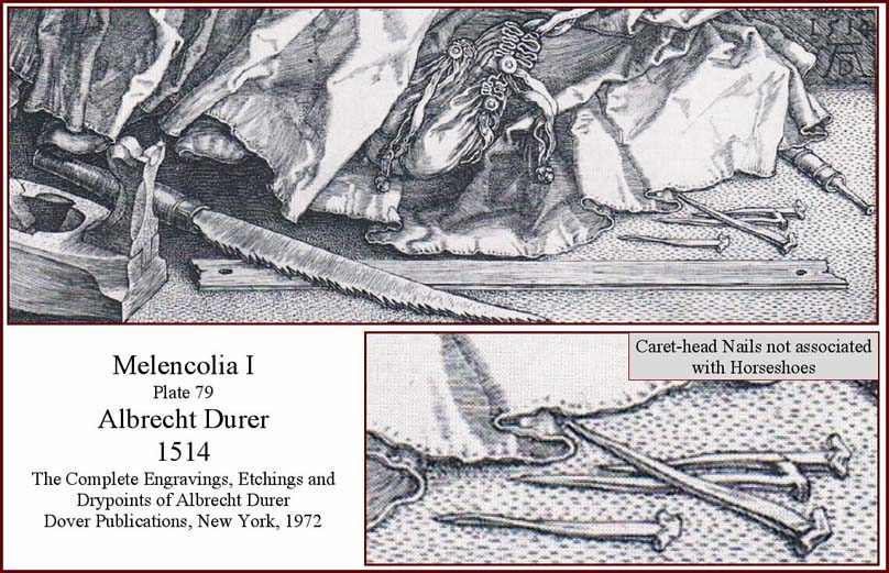
The appreciation of what is missing from the Kuykendall artifact collection reinforces our interpretive caution. Foremost among these absent artifacts are copper crossbow boltheads, caret-head horseshoe nails, and glass beads. At least one of these three types of artifacts has been found at the Jimmy Owens site, the LA 54147 site, and at Hawikku.
Our search for residuals of the Coronado Expedition at Kuykendall Ruins demonstrates that evidence of the captain generalÆs presence there in 1540 and 1542 is thin at best. Only a thoroughly exhaustive search of a large area should be considered adequate for any prospective short-duration Coronado campsite. Our 292-acre search at Kuykendall Ruins is unique among those explorations reported at accepted Coronado sites. The LA 54147 site measured 200meters by190 meters. Vierra reported: ōA surface reconnaissance of the site area was performed with a metal detector to find any early historic metal artifacts that might have been missed [by the excavations]. None was found.ö83 This suggests that the archaeologists searched 9.4 acres (3.8 hectares) at LA 54147. At Hawikku, Jonathan Damp reported a total of 5.9 acres (2.4 hectares) included in ōstudy units.ö He also notes thirteen additional transect lines, which, I calculate, cover an additional 2.4 acres (0.99 hectares), for a total of 8.3 acres (3.4 hectares) surveyed at Hawikku.84 These 8.3 acres were not grid surveyed but were randomly searched.85 The size of the area surveyed at the Jimmy Owens site is unknown at the time of this writing in 2008. Archaeologist Donald J. Blakeslee and his associate Jay C. Blaine reported in 2003 that ōthe main concentration of Spanish metal artifacts covers an area of about 350 by 200 meters (17.3 a, 7 h).ö However, the authors also describe the site as ōimmenseö; so the dimensions may be far larger. In 1998 Blakeslee stated to the Hesperian-Beacon newspaper of Floyd County, Texas, ōWe are digging at a site that is 230 meters wide and 450 meters long [25.6 a, 10.35 h].ö86
In comparison to these other surveys, the exploration at Kuykendall Ruins is quite expansive in geographic scale. Moreover, the team utilized a state-of-the-art metal detector in a closely spaced grid pattern. Despite the thorough search at Kuykendall, why has the team not yet found other diagnostic artifacts such as copper crossbow boltheads and caret-head horseshoe nails? The absence of anticipated artifacts at other Coronado sites is not without precedent. The Jimmy Owens site offers an example. While camped there in the summer of 1541, the Coronado Expedition was struck by a torbellino (twisting storm) that produced large hail. Casta±eda reported, ōThe [hail] stones tore open many tents and dented many helmets and hurt many horses and broke all the crockery and the gourd [containers] of the camp. . . .ö87 Based on the details of this chronicle, one would reasonably expect to find a large amount of broken pottery at the camp site, especially since Casta±eda reported that all the crockery was broken. Blakeslee and Blaine, however, state, ōTo date [2003], our excavations have uncovered only two concentrations of broken pottery of types that could have been in use in 1541, and each concentration contains shards from only a single vessel.ö88 In 2008 Richard Flint informed me that ōDr. BlakesleeÆs crews have found occasional utility ware sherds in close association with European objects, but we have no detailed information about them.89 These reports indicate that expectations of discovering an abundance of broken pottery at the Jimmy Owens site have not materialized, and that, in fact, the opposite has occurred.
The absence of European and central-Mexican pottery is the rule, not the exception, at all Coronado Expedition sites. Of LA 54147, Vierra writes: ōAll of the ceramics recovered from the site are native Puebloan earthen wares. There is no evidence of European influence in the ceramic industry.ö Damp reports that one small shard of European pottery was found at Hawikku but that its age and type had not been determined. As for Kuykendall Ruins, the team selected unusual shards from the surface, as well as some from the private collection of the landowner, and submitted more than one hundred of these to archaeologist Regge N. Wiseman for examination. He recognized neither central Mexican pottery nor European ceramics in the Kuykendall selection.90 This absence of European and central Mexican shards at Kuykendall Ruins corresponds to experiences at all other Coronado sites. These examples suggest that searchers expecting to find European or central Mexican potsherds at any potential Coronado site should not allow the lack of such evidence to condemn that prospect as a possible expedition camp.
Blakeslee approached the Jimmy Owens site with specific expectations when he began his exploration in 1995. Among the artifacts most likely left by the expedition, he believed, would be the residuals of the Mexican Indian contingent of the party. In 2003 he wrote: ōTo date, we have collected enough diagnostic material culture to determine to our satisfaction that this is a site of the Coronado Expedition . . . [but we have] been unable to identify the remains left by the Mexican Indians who made up much of CoronadoÆs armed force. We had hoped to find pieces of obsidian from central Mexico, and perhaps some pottery from their homeland as well.ö91 The Kuykendall team has encountered the same conundrum. Its members are convinced that Kuykendall Ruins are the fabled Chichilticale, but they wonder why they have not found, specifically, any caret-head horseshoe nails. The strong presence of the boltheads and the copper cuarto, plus the circumstantial-only evidence offered by the generic metal artifacts, augmented by nonmetal and historical evidence, overrides any lack of artifacts that the team expected to find.
So, why has the team failed to discover the expected residuals at Kuykendall Ruins? One explanation parallels that offered by Blakeslee and Blaine at the Jimmy Owens Site when they pondered why they had not found Mexican Indian artifacts: they concluded that they had ōnot found the Mexican Indian portion of the camp.ö Ergo, when the Kuykendall team finds all the Chichilticale camp, it will likely discover the site where the farriers dropped their caret-head nails. Our search has indicated a Chichilticale camp size of at least 221 acres (89 hectares). The Jimmy Owens camp ought to be somewhat similar in size and, at the very least, larger than the approximate 25 acres (10 hectares) reported by Blakeslee and Blaine.92 It is more likely than not that Blakeslee and his searchers will find the missing pottery once they expand their search area. Moreover, the Kuykendall team believes that the absence of specific categories of artifacts is not confirmation of their total absence from the site. Given all the unexpected evidence the team has found, its members have concluded that, rather than not having found the camp at all, their explorations have not yet determined the full extent of the Chichilticale camp.
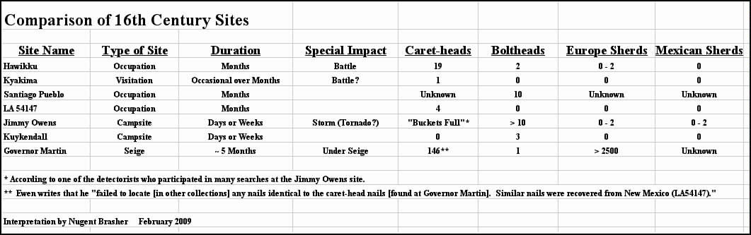
Exploration models evolve over time. The first discovery of a site type sets the standard, rightly or wrongly, for what searchers expect to find at similar sites. Archaeologist Charles R. Ewen chronicled the exploration of the Governor Martin site of the de Soto camp in Florida during 1539¢1540. His experiences and discoveries apply to exploration at both the Jimmy Owens site and Kuykendall Ruins. Ewen presents the opening question: ōWhat data should be found at the archaeological site if your hypothesis is true?ö Answering this question about the Governor Martin prospect, Ewen writes: ōThe site would have to conform to, or at least not contradict, the information contained within the narratives associated with the de Soto expedition. The geographical description of the area, taking into account modern alterations, should generally describe the area around the Governor Martin site. The location should lie within the parameters set out in the narratives. . . . The artifact assemblage should contain European artifacts, including types not normally associated with trade objects, in quantities that suggest onsite use.ö Both the Jimmy Owens site and Kuykendall Ruins satisfy their criteria for a site prospect. But Ewen prudently cautions: ōMeeting the above criteria would not prove that the Governor Martin site was Anhaica [de SotoÆs camp of 1539Ś1540]. However, it would make Governor Martin the leading contender in the absence of another site meeting the same criteria. Failing to disprove the hypothesis would allow its continued use to guide future research in the area.ö93 EwenÆs suggestion applies equally to the Jimmy Owens site and to Kuykendall Ruins.
The Kuykendall Ruins site represents the best exploration model of a Coronado trail camp. The Jimmy Owens site is a special case because it was greatly impacted by the torbellino. Hawikku and Kyakima were battle and occupation sites. LA 54147 was an occupation site. Only Kuykendall was a standard overnight campsite. On-trail Coronado sites explored in the future should be compared to Kuykendall Ruins with respect to the camp size, spatial array of artifacts, presence of water, fuel, and comfort, and the historical setting as described in the written record. Given the evidence to date and the satisfaction of the Ewen criteria, historians and archaeologists should give due consideration to Kuykendall Ruins as being the fabled Chichilticale until someone convincingly disproves the hypothesis.
Future Work
Blakeslee writes, ōWith every site, there comes the question of how much further work is justified.ö94 The Kuykendall Ruins site warrants further exploration. The current exploration hypothesis predicts that the farrier site will be found downstream along Ruins Arroyo at a place where water, wood, and shade were available and where horses standing in the water would not have contaminated drinking water. This prediction calls for the extension of metal-detector surveys to the west along Ruins Arroyo. Optically Stimulated Luminescence (OSL) dating should be conducted on a significant number of the thermal features suspected to be Coronado campfires. The number of dates obtained must be sufficient to provide a statistically relevant conclusion. In addition lead isotope ratios should be obtained for the four lead balls found at the ruins. Those results should be compared to known ratios taken from lead balls found at the Hawikku, Kyakima, and Jimmy Owens sites. The regat¾n found on Ruins Plain might contain nonmineralized wood in the ferrule. If so, a non-destructive means for obtaining a wood sample should be designed in order to determine a carbon-fourteen date from it. The team hopes to conduct these laboratory tests in the future; it will publish the results at a later time. Finally, detailed surface reconnaissance to enlarge the prospective site of CoronadoÆs camp should be extended in both directions along Ruins and Clearings arroyos.
The Chichilticale Campsite
The exploration of Kuykendall Ruins provides persuasive evidence that it is the site of the fabled Red House called Chichilticale by the Spaniards. The location sits four days from the head of the Arroyo Nexpa (RĒo San Pedro), two days from where the expedition turned to the right (Lewis Spring) and one day from the deep, high-banked arroyo (Siphon Canyon in Apache Pass), thus fitting neatly into the route described by Jaramillo. Again fulfilling the route descriptions by Jaramillo and Casta±eda, the ruins lie at the foot of the Chiricahua Mountains to the southwest of where that north-trending range turns sharply at Apache Pass to become the northwest-trending Dos Cabezas Mountains. The ruins are of red adobe, as Casta±eda noted in his account.95
The metal artifacts discovered at Kuykendall include pieces that are almost certainly of sixteenth-century vintage and are of a form and function known to have been carried by the expedition. The types of artifactsŚnails, spikes, clothing fasteners, needles, awls, chains, toolsŚrepresent items that mobile people intending to establish a permanent presence would have brought along for that purpose, and most of CoronadoÆs expeditionaries intended to remain in Tierra Nueva.96 Shaped like a polygon, the Coronado site explored by the team is 221 acres (89 hectares), and it measures 1.1 miles (1.8 kilometers) in length and 0.6 miles (987 meters) in width. The campÆs shape was dictated by Ruins Arroyo, which offered water, shade, and fuel, and by Ruins Plain, which offered grass-free, level terrain for tent sites. The quantity and concentration of thermal features, possibly arranged by members of the expedition, provides evidence of cooking, an essential camp activity. The size and location of the camp satisfies such requirements for the approximately two thousand humans and five thousand livestock composing the Coronado Expedition, while minimizing the likelihood that the artifacts the team found were dropped by a small party associated with the larger expedition.97 All this evidence supports the claim that Kuykendall Ruins are what Coronado and his men referred to as their Chichilticale in 1540 and 1542.
Acknowledgments
The fieldwork associated with this exploration could never have been accomplished without the combined efforts of the team on the ground. Gordon Fraser served as maestre de campo, providing continual, tireless assistance as well as knowledge and expertise that only a native guide could contribute. John Blennert graciously furnished the state-of-the-art equipment and expert instruction that produced the rewarding results, and he found a number of the most important artifacts. Dan Kaspar traveled from distant Texas numerous times to ōgive a weekö searching the site, and this proven finder was singularly responsible for many of the major artifactual discoveries. Marc Kaspar and Loro Lorentzen unselfishly contributed time in the field and on the road. Without the unequivocal cooperation of the landownersŚthe Donka, Riggs, and Gill familiesŚthis exploration would have been impossible. The entire team extends its warmest gratitude for allowing us onto their land. The exploration program has continued since September 2004, and Carroll L. Riley, Brent Locke Riley, Richard Flint, and Shirley Cushing Flint advised the team throughout that entire four-year trekŚmany thanks to those four for their support and counsel. Durwood Ball and his most accommodating staff at the New Mexico Historical Review provided the opportunity to publish the Kuykendall findings and the team is truly indebted for the flexibility they afforded. Karl W. Laumbach provided guidance and gently counseled patience. Michael R. Waters, Director of the Center for the Study of the First Americans at Texas A&M University, generously offered his respected counsel. Professional scientific contributions to the Kuykendall program include those by archaeologists Deni J. Seymour, David Killick, and Paul Fish, archaeological conservator Pearce Paul Creasman, curator Donald J. La Rocca, geologists Philip A. Pearthree, Ann Youberg, and Joseph P. Cook, metallurgist Abe Gundiler, numismatist Alan M. Stahl, and southwestern ceramic specialist Regge N. Wiseman. Contributors to the identification of artifacts include all the scholars recognized in note 11. To them I extend my deepest thanks. Among that group, Chester DePratter, Jim Legg, Jerry Lee, and John Powell deserve particular mention. Special recognition is due blacksmith Frank Turley in Santa Fe, who always delivered his honest appraisal of the identity of the pieces I showed him, and who constantly reminded us both of the dangers of ōreaching out.ö Team members also thank Jonathan E. Damp for providing complete access to the Hawikku artifact collection at the Zuni Cultural Resource Enterprise, and to Floyd County Historical Museum founder and director Nancy Marble for allowing the examination of the valuable Coronado collection in Floydada. Dozens of scholars worldwide provided me their suggestions, and, although they are unnamed here, they are all in my memory. Bernard L. ōBunnyö Fontana directed and guided my research into the history of Sulphur Springs ValleyŚthank you, Sir. The tall and comforting shadows of Jack and Vera Mills guided the team at Kuykendall Ruins, and I personally acknowledge these two cartographers as the ones who actually mapped what Coronado saw. My father, whoÆs name I carry, instilled in me curiosity, determination, and tenacity, qualities that proved mandatory for this exploration, and I am beholden to him for our success. Of course, this four-year adventure could have happened only with the unconditional support, gentle and thoughtful criticism, and enduring love of my wife Karen, to whom I gift this discovery.
1. Nugent Brasher, ōThe Chichilticale Camp of Francisco Vßzquez de Coronado: The Search for the Red House,ö New Mexico Historical Review 82 (fall 2007): 433¢68.
2. Ibid., 462.
3. Jack P. Mills and Vera M. Mills, The Kuykendall Site: A Prehistoric Salado Village in Southeastern Arizona, Special Report, no. 6, ed. Vernon Ralph Brook (El Paso, Tex.: El Paso Archaeological Society, 1967), 41, 69, 107, 110.
4. Tom Kuykendall told me in November 2005 that ōat the end of the excavation [1961], Jack and Vera covered everything up and smoothed it all out real nice. You couldnÆt even see that theyÆd ever been there. Years later some bulldozers came in and tore hell out of the place looking for pots.ö Tom Kuykendall is the son of Leslie and Kate Kuykendall, the landowners of Kuykendall Ruins when it was excavated by Jack and Vera Mills. Tom Kuykendall, phone conversation with author, November 2005.
5. FF:2:6 was reported by archaeologists Anne I. Woosley and associates, see Anne I. Woosley, Tim Price, and D. Carol Kriebel, Archaeological Survey of the Sulphur Spring Valley, Southeast Arizona, Publications, no. 12 (Dragoon, Ariz.: Amerind Foundation, 1987), 70.
6. Susan M. DuBois and Ann W. Smith, The 1887 Earthquake in San Bernardino Valley, Sonora: Historic Accounts and Intensity Patterns in Arizona, Special Paper, no. 3 (Tucson: State of Arizona, Bureau of Geology and Mineral Technology, University of Arizona, 1980), 80, 82.
7. Philip A. Pearthree, e-mail message to author, 6 June 2007.
8. The Australian manufacturer and the American dealer of Coil-Tek reported that we were the only explorers using such an innovation in the United States. Moreover, they knew of no one anywhere using the technology for an archaeological investigation. John C. Blennert who donated the Coil-Tek is an internationally recognized meteorite and gold prospector. Specimens he has discovered are on display at the Flandrau Science Center University of Arizona Mineral Museum. The Catalina Sky Survey, University of Arizona Department of Planetary Sciences, Lunar and Planetary Laboratory, recognized John as co-discoverer of the Gold Basin Meteorite strewnfield by naming ōMain Belt asteroid 97637 Blennertö in his honor.
9. Frank Turley, e-mail message to author, 12 December 2007.
10. I have listed the Southeasterners in the order we met them: Gifford J. Waters, Collection Manager, Historical Archaeology, Florida Museum of Natural History, Gainesville; William R. Adams, Director, Government House Museum, St. Augustine; John T. Powell, Colonial Spanish Quarter, conservator and private collector, St. Augustine; Robert Spratley, private collector, St. Augustine; Stanley A. South, Research Archaeologist, South Carolina Institute of Archaeology and Anthropology (SCIAA), Columbia; Chester DePratter, Head of Research Division, SCIAA, Columbia; James B. Legg, Collections Expert, SCIAA, Columbia; Bryan P. Howard, Curator, Parris Island Museum, Parris Island; David Dickel, Research and Conservation Laboratory Supervisor, Florida Department of State (DOS), Bureau of Archaeological Research (BAR), Tallahassee; James Levy, Historical Conservator, Research and Conservation Laboratory, DOS, BAR, Tallahassee; Marie Prentice, Conservation and Collections, Research and Conservation Laboratory, DOS, BAR, Tallahassee; Roger Smith, Archaeology Supervisor, Underwater Archaeology, DOS, BAR, Tallahassee; Louis D. Tesar, Archaeologist III, DOS, BAR, Tallahassee; Jerry W. Lee, Senior Archaeologist, Mission San Luis, DOS, Tallahassee; John R. Bratten, Nautical Archaeologist/Conservator, Archaeology Institute, University of West Florida, Pensacola; Judith A. Bense, Director, Division of Anthropology and Archaeology, University of West Florida, Pensacola; Janet Lloyd, Laboratory Director, Archaeology Institute, University of West Florida, Pensacola; Eugene Lyon, Flagler College Center for Historic Research, St. Augustine Foundation, St. Augustine: Joy MacMillan, Executive Director, St. Augustine Foundation, St. Augustine; Kathleen Deagan, Distinguished Research Curator of Archaeology, Florida Museum of Natural History, Gainesville. Their generous support has helped amplify the historical significance of the artifacts found at the Kuykendall site.
11. Brasher, ōThe Chichilticale Camp,ö 460.
12. Ibid., 456¢57 ; and Mills and Mills, The Kuykendall Site, 54, 83.
13. If an artifact was discovered by an individual, other than myself, while ōswinging sticks,ö I will name the team member. If an artifact was found as a result of the Blennert Sled, no individuals will be named.
14. Brasher, ōThe Chichilticale Camp,ö 453.
15. Bradley J. Vierra, A Sixteenth-Century Spanish Campsite in the Tiguex Province, Laboratory of Anthropology Notes, no. 475 (Santa Fe: Museum of New Mexico, Laboratory of Anthropology, Research Section, 1989), 125.
16. Frank Turley, e-mail message to author, 22 January 2008.
17. Donald J. La Rocca, e-mail message to author, 8 April 2008.
18. Pablo MartĒn G¾mez, Hombres y Armas en la Conquista de Mķxico (Madrid, Espa±a: Almena Ediciones, 2001), 81, 173. G¾mezÆs work is in Spanish and the translations presented herein are mine.
19. Ibid., 83. Although G¾mez does not italicize the word ōregat¾n,ö I have italicized it because this is the first reference to the Spanish term in the text. Richard Flint states that the Spanish term ōregat¾n was commonly spelled recat¾n in the 16th century. The word is defined by Sebastißn de Covarrubias Orozco, in his 1611 Tesoro de la Lengua Castellana o Espanola. (Edited by Felipe C. R. Maldonado. 2nd ed. Madrid: Editorial Castalia, 1995. Originally published Madrid: Luis Sßnchez, 1611) p. 852: æEs el extremo de la lanza, opuesto al hierro.Æö Richard Flint, e-mail message to author, 8 June 2008.
20. G¾mez, Hombres y Armas, 84.
21. Walter Karcheski Jr., Arms and Armor of the Conquistador, 1492¢1600: A Catalogue of Arms and Armor from the Exhibit, First Encounters, Spanish Explorations of the Caribbean and United States, 1492¢1570 (Gainesville: Florida Museum of Natural History, 1990), 5.
22. Richard Flint provided the translation of Bernardo Vargas MachucaÆs work, see Bernardo Vargas Machuca, Milicia y descripcion de las Indias (1599; repr., Madrid: Victoriano Sußrez, 1892), 212.
23. Pedro de Casta±eda de Nßjera, ōThe Relaci¾n de la Jornada de CĒbola, Pedro de Casta±eda de NßjeraÆs Narrative, 1560s (Copy, 1596),ö in Documents of the Coronado Expedition, 1539¢1542: ōThey Were Not Familiar with His Majesty, nor Did They Wish to be His Subjects,ö ed., trans., and annot. Richard Flint and Shirley Cushing Flint (Dallas, Tex.: Southern Methodist University Press, 2005), 446.
24. Ibid., 480.
25. Ibid., 449.
26. Casta±eda, ōRelaci¾n,ö 461. The FlintsÆ transcripts are in Spanish. The translations presented herein are mine. I have also italicized the first reference of the Spanish terms.
27. ōMuster Roll of the Expedition, Compostela, February 22, 1540,ö in Documents of the Coronado Expedition, 1539¢1542 ed., trans., and annot. Flint and Flint, 137, fig. 12.1.
28. G¾mez, Hombres y Armas, lßmina 10.
29. Abe Gundiler, letter to author, 5 June 2007.
30. Alan M. Stahl, e-mail message to author, 23 April 2008. Stahl had worked at the 1494¢1498 La Isabela Columbus site and the 1539¢1540 Governor Martin de Soto site.
31. Hal Birt, a coin appraiser in Tucson, Arizona believes that the Kuykendall cuarto is the oldest reported coin ever found in Arizona. It is highly likely that the coin represents the oldest non¢Native American object discovered in the state. Hal Birt, telephone conversation with author, 3 May 2008.
32. Richard FlintÆs e-mail message of 10 June 2008 stated: ōTwo coins were found at the Jimmy Owens site in 1996 and only recently made known. They were identified by Dr. Michael Mathes as a æblanca and a half cuartillo from the reign of Enrique IV (1435¢1475).Æ Both are struck from vell¾n, an amalgam of silver and copper. Both are depicted in Juan R. Cay¾n, Las Monedas Hispano Musulmanas y Cristianas , 711¢1981 (Madrid: Artegraf, 1980), 200¢201.ö Five copper coins were found at the Governor Martin site. Dozens of coins were excavated at La Isabela. A cuarto was found at Puerto Real. See Charles R. Ewen and John H. Hann, Hernando de Soto among the Apalachee: The Archaeology of the First Winter Encampment, Ripley P. Bullen series (Gainesville: University Press of Florida, 1998), 80¢82; Kathleen Deagan and Josķ MarĒa Cruxent, Archaeology at La Isabela: AmericaÆs First European Town (New Haven, Conn.: Yale University Press, 2002), 289; and Kathleen Deagan, ed., Puerto Real: The Archaeology of a Sixteenth-Century Spanish Town in Hispaniola, Ripley P. Bullen series (Gainesville: University Press of Florida, 1995), 18¢19, 267¢69.
33. David Killick, e-mail message to author, 13 June 2007.
34. Janet Arnold, Patterns of Fashion: The Cut and Construction of Clothes for Men and Women, c1560¢1620 (Hollywood, Calif.: Quite Specific Media Group, 1985), 51.
35. Frank Turley, e-mail message to author, 6 January 2008.
36. The standard work on the archaeology of La Isabela is Archaeology at La Isabela: AmericaÆs First European Town (2002).
37. Frank Turley, e-mail message to author, 24 March 2007.
38. Stanley South, Russell K. Skowronek, and Richard E. Johnson, Spanish Artifacts from Santa Elena, Anthropological Studies, no. 7 (Columbia: South Carolina Institute of Archaeology and Anthropology, 1988), 326 .
39. Since the team found a complete round, wrought-iron chain link, Frank Turley states: ōMost all chain is made of round stock, because of the ease of swing and rotation where each link meets. It allows the chain to be collapsible and to curve more easily than if it were square stock . . . If forging a square section bar into a round section, the smith forges in the corners, forming an octagonal cross-section. He then forges in the remaining ōpeaksö or lines to finally arrive at a round section. If the smith wants a round [piece] to become square sectioned, he hits the iron giving it quarter turns until it becomes square. Surely all smiths had round sectioned iron in all centuries of the Iron Age. It could simply be hammered to a round shape.ö Frank Turley, e-mail message to author, 7 January 2008.
40. Bead specialists consulted by the Kuykendall team are the following: Karen Karn, collections manager, The Bead Museum, Glendale, Arizona; Marvin T. Smith, professor of Anthropology, Valdosta State University, Georgia; Karlis Karklins, archaeologist and editor of Beads: Journal of the Society of Bead Researchers, Ottawa, Ontario, Canada; Jamey D. Allen, co-founder of Society of Bead Researchers and consulting curator, The Bead Museum, Glendale, Arizona; and Christopher R. DeCourse, professor and chair, Department of Anthropology, Syracuse University, New York.
41. Marvin T. Smith, Elizabeth Graham, and David M. Pendergast, ōEuropean Beads from Spanish-Colonial Lamanai and Tipu, Belize,ö Beads: Journal of the Society of Bead Researchers 6 (1994 ), 21¢47.
42. Kathleen Deagan, Artifacts of the Spanish Colonies of Florida and the Caribbean, 1500¢1800 (Washington, D. C.: Smithsonian Institution Press, 1987), 180¢83.
43. These objects are too ambiguous to be included in the overall count of Coronado Expedition artifacts. Nevertheless, their presence is definitely worth mentioning because they were discovered amongst the burned rocks and the hooklets.
44. Brasher, ōThe Chichilticale Camp,ö 459.
45. Jonathan E. Damp, The Battle of Hawikku, Research Series 13, Report no. 884 (Zuni, N.Mex.: Zuni Cultural Resource Enterprise, 2005), 99¢101.
46. Louis Tesar, personal communication with author, 20 February 2008.
47. Brasher, ōThe Chichilticale Camp,ö 459.
48. John Powell, e-mail message to author, 12 April 2007.
49. John Powell, telephone conversation with author, 21 May 2008.
50. The U.S. Board on Geographic Names decided in 1959 to adopt the name Sulphur Springs Valley, which became effective 8 February 1980. Many older references and maps also use the name Sulpher Spring Valley or Sulphur Spring Valley. For more information, see http://geonames.usgs.gov/.
51. Oscar Edward Meinzer, F. C. Kelton, and Robert Humphrey Forbes, Geology and Water Resources of Sulphur Spring Valley, Arizona (Washington, D.C.: GPO, 1913), 11.
52. Juan Nentvig, Descripci¾n geogrßfica, natural y curiosa de la Provincia de Sonora, ed. Germßn Viveros, Publicaciones del Archivo General de la Naci¾n, Segunda Serie, no. 1 (Mķxico, D.F.: Archivo General de la Naci¾n, 1971), 64¢65. Nentvig spells the Chiricahua Mountains as ōChiguicagui.ö
53. Edward H. Spicer, Cycles of Conquest: The Impact of Spain, Mexico, and the United States on the Indians of the Southwest, 1533¢1960 (1962; repr., Tucson: University of Arizona Press, 1976), 231¢45.
54. Thomas H. Naylor and Charles W. Polzer, S. J., comps. and eds., The Presidio and Militia on the Northern Frontier of New Spain: A Documentary History, 2 vols. (Tucson: University of Arizona Press, 1986), 1:485, 548, 583.
55. Juan Fernßndez de la Fuente, ōA Campaign against the Pimasö in The Presidio and Militia, comp. and ed. Naylor and Polzer, 1:640, 702.
56. Ibid., 643.
57. Ibid., 710.
58. Eusebio F. Kino, KinoÆs Historical Memoir of PimerĒa Alta: A Contemporary Account of the Beginnings of California, Sonora, and Arizona, by Father Eusebio F. Kino, S.J., Pioneer Missionary Explorer, Cartographer, and Ranchman, 1683¢1711, from the Original Manuscript in the Archives of Mexico, trans., ed., and annot. Herbert E. Bolton, 2 vols. (Berkeley: University of California Press, 1948), 1:164¢65; and Hubert H. Bancroft, History of Arizona and New Mexico, The Works of Hubert Howe Bancroft, vol. 17 (San Francisco: The History Company, 1889), 355. The quotation is from Bancroft, History of Arizona and New Mexico, 356 n. 2. Spicer, Cycles of Conquest, 233; andJay J. Wagoner, History of the Cattle Industry in Southern Arizona, 1540¢1940, Social Science Bulletin, no. 20, University of Arizona Bulletin, vol. 23, no. 20 (Tucson: University of Arizona Press, 1952), 16.
59. Spicer, Cycles of Conquest, 152, 236, 237; and Wagoner, History of the Cattle Industry, 17.
60. James E. Officer, Hispanic Arizona, 1536¢1836 (Tucson: University of Arizona Press, 1989), 4, 36; John Francis Bannon, The Spanish Borderlands Frontier, 1513¢1821, Histories of the American Frontier Series (Albuquerque: University of New Mexico Press, 1974), 149¢50; and Donald T. Garate, Juan Bautista de Anza: Basque Explorer of the New World (Reno: University of Nevada Press, 2005), 80¢81.
61. Ibid.; Peter Aleshire, Cochise: The Life and Times of the Great Apache Chief (New York: John Wiley and Sons, 2001), 16; Edwin R. Sweeney, Cochise: Chiricahua Apache Chief, The Civilization of the American Indian series(Norman: University of Oklahoma Press, 1991), 8; and Spicer, Cycles of Conquest, 238¢39.
62. For a discussion of the Spanish peace policy, see William B. Griffen, Apaches at War and Peace: The Janos Presidio, 1750¢1858 (Albuquerque: University of New Mexico Press, 1988), 14, 119, 122¢24. Wagoner, History of the Cattle Industry, 22; and Sweeney, Cochise: Chiricahua Apache Chief, 9.
63. Ethnohistorian Bernard L. Fontana provided information suggesting that commerce improved during this lull in hostilities. His e-mail message included the quote from Sonoran Alberto Suarez. Fontana, e-mail message to author, 28 March 2008; Jack. S. Williams, telephone interview with author, 10 August 2007; Spicer, Cycles of Conquest, 240; and Sweeney, Cochise: Chiricahua Apache Chief, 10.
64. George P. Hammond, [ed.], ōThe Z·±iga Journal, Tucson to Santa Fķ: The Opening of a Spanish Trade Route, 1788¢1795,ö in New Mexico Historical Review 6 (January 1931), 40¢41.
65. Nentvig, Descripci¾n geogrßfica, 64¢65, map; and Hammond, [ed.], ōThe Zu±iga Journal,ö 42.
66. Juan Jaramillo, ōJuan JaramilloÆs Narrative, 1560s,ö in Documents of the Coronado Expedition, 1539¢1542, ed., trans., and annot. Flint and Flint, 520.
67. For the purpose of this article, only the movements of EcheagarayÆs troops in the Chiricahua Mountain region will be narrated. Hammond, [ed.], ōThe Zu±iga Journal,ö 43¢46.
68. Ibid., 47, 49.
69. Joseph de Z·±iga, 9¢10 April, 12¢16 April, ōUna expedici¾n militar de Tucson (Arizona) a Zu±i (Nuevo Mķxico),ö in La Espa±a ilustrada en el Lejano Oeste: viajes y exploraci¾nes por las provincias y territorios hispßnicos de Norteamķrica en el siglo XVIII, ed. Amando Represa, Estudios de historia (Valladolid: Junta de Castilla y Le¾n, 1990) 89¢100. See especially pp. 91¢92 , which refer to Z·±igaÆs journal entries for 9¢10 April and 12¢16 April. Represa incorrectly reports the year as 1791; the actual year was 1795.
70. Ibid., 98.
71. Map of Arizona Territory, prepared under the direction of 1st Lt. Frederick Appleton Smith, compiled and drawn by Paul Riecker (Washington, D.C.: U.S. Engineer Office, 1879).
72. John Powell, e-mail messages to author, 8 August 2007 and 27 August 2007.
73. Z·±iga, 28 April, 12 May 1795, ōUna expedici¾n militar,ö 94, 96.
74. My interpretation of these Julian calendar Coronado campsite dates is anchored by three events: the arrival of the advance army at CĒbola on 7 July 1540, the departure of the following army from Se±ora in ōmediado septiembreö (middle September) 1540, and the RĒo FrĒo camp of the retreating army on 9 April 1542. Using these temporal anchors and my interpretation of the trail and travel times, I constructed calendars and campsites for all three armies between Ispa and CĒbola. The sources I used as a basis for my calculations are ōTraslado de las Nuevas, 1540,ö in Documents of the Coronado Expedition, 1539¢1542, ed., trans., and annot. Flint and Flint, 294; Casta±eda, ōRelaci¾n,ö 447; and ōDisposal of the Juan Jimķnez Estate, 1542 (Copy, 1550),ö in Documents of the Coronado Expedition, 1539¢1542, ed., trans., and annot. Flint and Flint, 373.
75. Officer, Hispanic Arizona, 68, 295, map, 110, 149; Spicer, Cycles of Conquest, 240; Wagoner, History of the Cattle Industry, 25; and Bert Haskett, ōEarly History of the Cattle Industry in Arizona,ö Arizona Historical Review 6, no. 4 (1935): 3.
76. Officer, Hispanic Arizona, 128¢30.
77. Sweeney, Cochise: Chiricahua Apache Chief, 24.
78. Officer, Hispanic Arizona, 130, 224; Spicer, Cycles of Conquest, 241, 244¢45; William W. Hunter, Diary-Journal of Events, etc. on a Journey from Missouri to California, 1849, pp. 109¢10, AZ 403, Special Collections, University of Arizona, Tucson; Robert Eccleston, Overland to California on the Southwestern Trail, 1849: Diary of Robert Eccleston, ed. George P. Hammond and Edward H. Howes, Bancroft Library Publications, no. 2 (Berkeley: University of California Press, 1950), 174¢93; Sweeney, Cochise: Chiricahua Apache Chief, 73¢74; James Ohio Pattie, The Personal Narrative of James O. Pattie: The True Wild West of New Mexico and California, ed. Timothy Flint (Santa Barbara, Calif.: The Narrative Press, 2001), 87¢94; Carl D. W. Hays, ōDavid E. Jackson,ö in The Mountain Men and the Fur Trade of the Far West: Biographical Sketches of the Participants by Scholars of the Subject and with Introductions by the Editor, ed. LeRoy R. Hafen, vol. 9 (Glendale, Calif.: Arthur H. Clark Company, 1972), 232¢34; Philip St. George Cooke, The Conquest of New Mexico and California in 1846¢1848 (Chicago: RĒo Grande Press, 1964), 139¢44, map front cover; and Cave Johnson Couts, Hepah, California!: The Journal of Cave Johnson Couts from Monterey, Nuevo Leon, Mexico, to Los Angeles, California, during the Years 1848¢1849, ed. Henry F. Dobyns (Tucson: Arizona PioneersÆ Historical Society, 1961), 49¢54.
79. John Russell Bartlett, Personal Narrative of Explorations and Incidents in Texas, New Mexico, California, Sonora, and Chihuahua, Connected with the United States and Mexico Boundary Commission during the years 1859, æ51, æ52, and æ53 (1854; repr., Chicago: RĒo Grande Press, 1965), 368¢78; Vernon B. Schultz, Southwestern Town: The Story of Willcox, Arizona (Tucson: University of Arizona Press, 1964), 17, 48; and William R. Turvey, US Patent 326188, filed 1913.
80. Kino, KinoÆs Historical Memoir of PimerĒa Alta, 1:162¢63.
81. Turley, e-mail message, 7 January 2008.
82. La Rocca, e-mail message, 8 April 2008; and Turley, e-mail message, 6 January 2008.
83. Vierra, A Sixteenth-Century Spanish Campsite, 26¢27.
84. Damp, The Battle of Hawikku, 22¢24.
85. Jeff Waseta and Davis Nieto (supervisory archaeologists for the Zuni Cultural Resources Enterprise), in communication with the author, 30 May 2007.
86. Donald J. Blakeslee and Jay C. Blaine, ōThe Jimmy Owens Site: New Perspectives on the Coronado Expedition,ö in The Coronado Expedition: From the Distance of 460 Years, ed. Richard Flint and Shirley Cushing Flint (Albuquerque: University of New Mexico Press, 2003), 205, 210; and Floyd County (TX) Hesperian-Beacon, 11 June 1998.
87. Casta±eda, ōRelaci¾n,ö 465.
88. Blakeslee and Blaine, ōThe Jimmy Owens Site,ö 215.
89. Richard Flint, e-mail message to author, 14 June 2008.
90. Vierra, A Sixteenth-Century Spanish Campsite, 75; Jonathan E. Damp, personal communication with author, 14 June 2008; and Regge N. Wiseman, personal communication with author, 23 January 2008.
91. Blakeslee and Blaine, ōThe Jimmy Owens Site,ö 217.
92. Ibid.
93. Charles R. Ewen and John H. Hann, Hernando de Soto among the Apalachee: The Archaeology of the First Winter Encampment, Ripley P. Bullen series (Gainesville: University Press of Florida: 1998), 52¢53.
94. Blakeslee and Blaine, ōThe Jimmy Owens Site,ö 217.
95. See Brasher, ōThe Chichilticale Camp,ö 437¢38, 441.
96. Richard Flint and Shirley Cushing Flint, the leading scholars of the Coronado Expedition, state: ōWhat drew the expedition to the Southwest was principally the prospect of populous and wealthy native peoples from whom significant tribute likely could be extracted. More than raw precious metals, gemstones, or pearls . . . it was the indigenous people themselves who were the chief attractions. . . . Thus, when the expedition withdrew from Tierra Nueva in 1542 it was because æthere was no settlement in what had been reconnoitered where repartimientos [encomiendas] (tribute and labor) could be made to the whole expedition.Æö Richard Flint and Shirley Cushing Flint, eds., trans., and annot., general introduction to Documents of the Coronado Expedition, 1539¢1542: ōThey Were Not Familiar with His Majesty, nor Did They Wish to be His Subjects,ö (Dallas, Tex.: Southern Methodist University Press, 2005) 3, 706.
97. Brasher, ōThe Chichilticale Camp,ö 435.
