The Francisco Vázquez de Coronado Expedition in
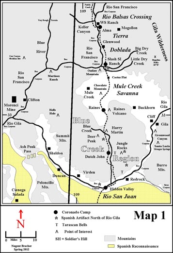
Tierra Doblada
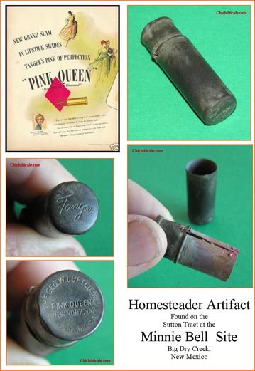
The 2013 Report on Artifacts and Isotopes of the Minnie Bell Site at Big Dry Creek, Catron County, New Mexico
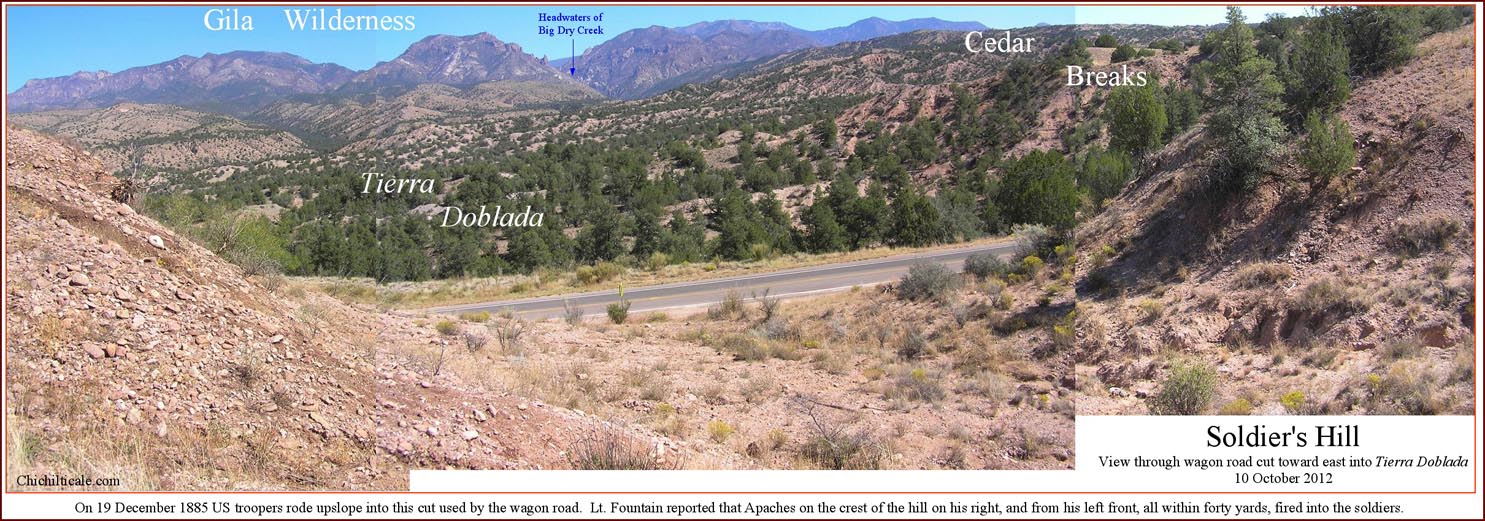
The Apache bullet struck Dr. Maddox in the chest, smacking his commanding figure off his big buckskin horse. Two troopers tried to drag him to cover, but another bullet blasted through the back of his head, exiting at the corner of his mouth, leaving a jagged scar, ending his life. The surgeon had been amongst the leaders in a troop of seventeen soldiers that had just departed their camp at Big Dry Creek when the ambush began with a volley of shots that killed four soldiers, several horses and mules, and the doctor. The tragedy began and ended suddenly that frigid December morning in 1885, and in the confusion the Apaches managed to loot the arms and ammunition of the dead before escaping into up-and-down terrain impossible for pursuit by the soldier’s horses. The dead men were gathered and carried to the nearby Siggins ranch house. The horse and mule carcasses were rolled over the edge of the road, where they froze, dried, and finally withered away, the skeletons remaining for years, creating a white landmark to point at when tellers recounted the tale of the waylay.
More than a half-century after the ambush, a seven-year-old girl picked up some of the spent casings left by the Apache rifles. “There’s history here,” said the gentle man who had shown her the ambush site. And there was, and it was even more than either of them knew – for some 400 years earlier a Spanish Captain General may have also stood at that very spot. This is the story of Coronado at Big Dry Creek.(1)
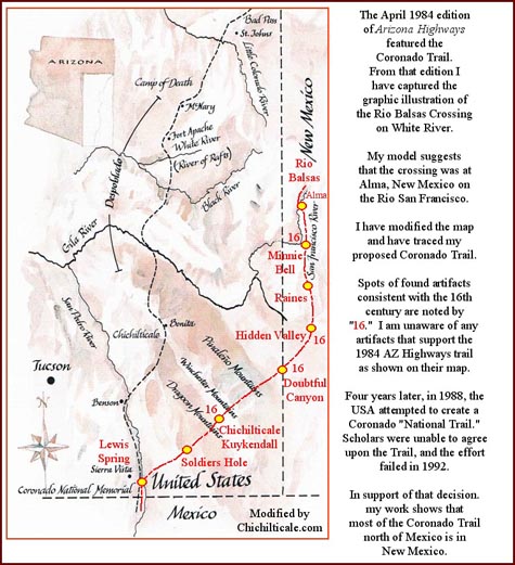
Beginning in the summer of 2009, my exploration to determine the route of Capt. Gen. Francisco Vázquez de Coronado focused on the trail between the Río Gila in New Mexico on the south and Alma, New Mexico on the north.(2) Of this portion of the route, Juan "El Mozo" Jaramillo, horseman in the 1540 advance party of the Coronado Expedition, recollecting some twenty years after the fact, offered the only description of the northbound Coronado Trail along that trace.
“After leaving here [Río San Juan] we went to another river, by way of land somewhat uneven [doblada], moving more to the north. The river we named Las Balsas because we crossed in rafts because the river was swollen. It seems to me that we took two days from one river to the other, and this [uncertainty] I say because it has been so long since that happened to us that I could be mistaken in some days…”(3)
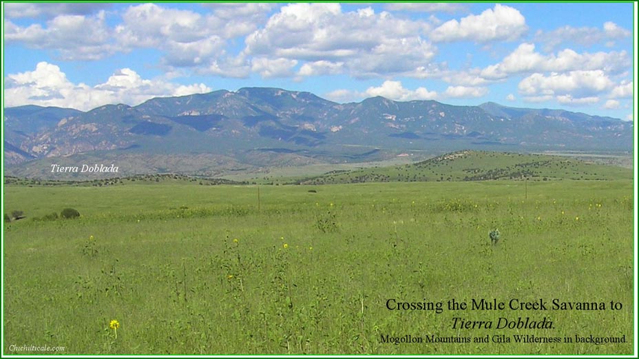
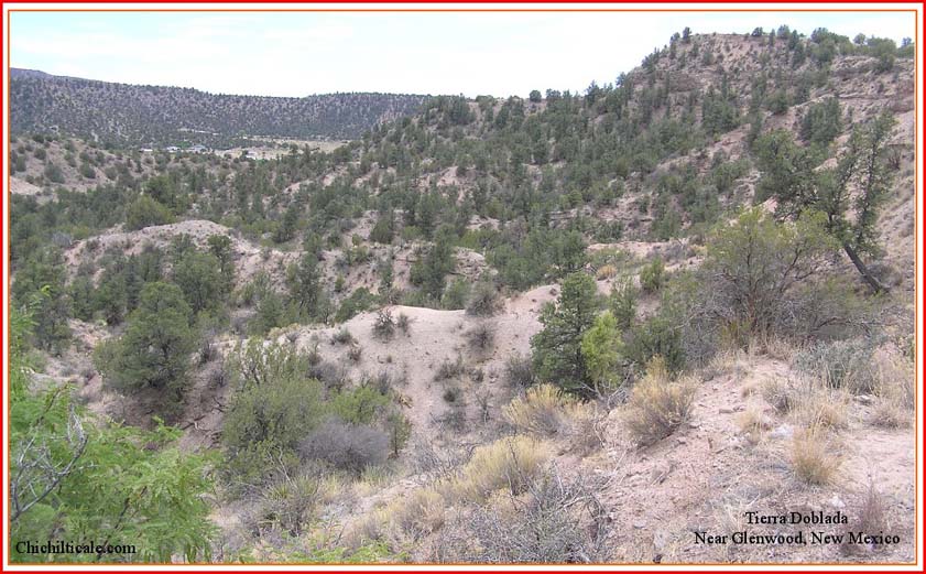
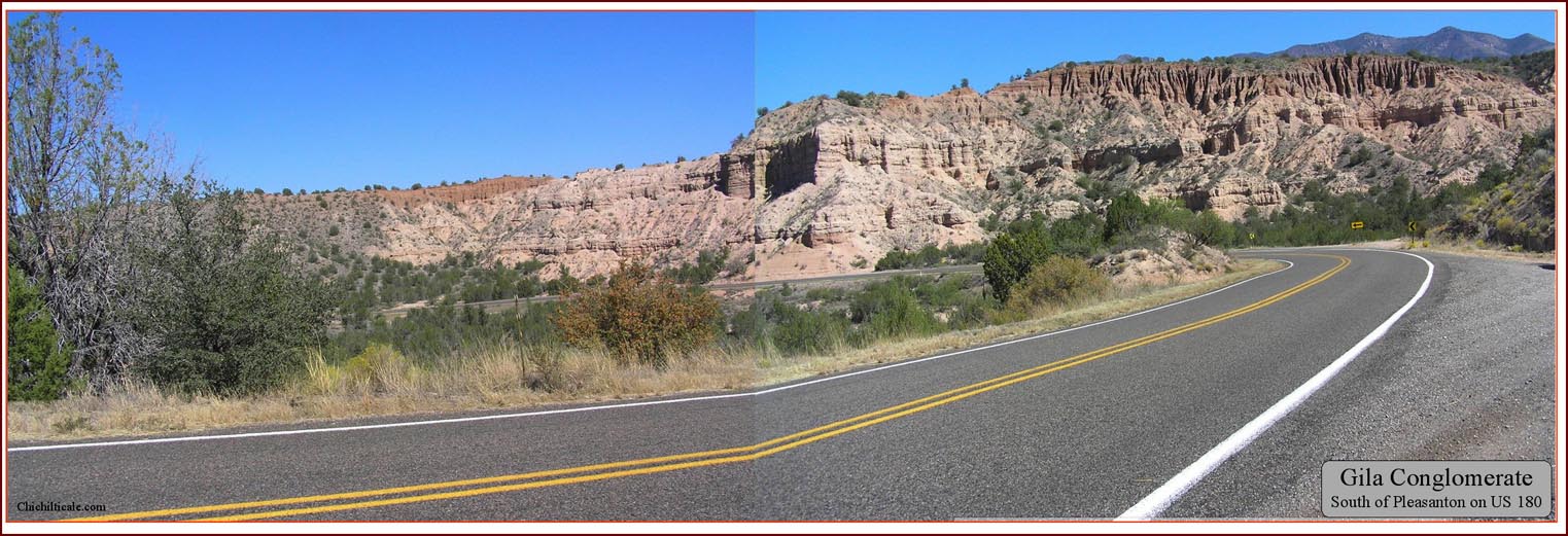
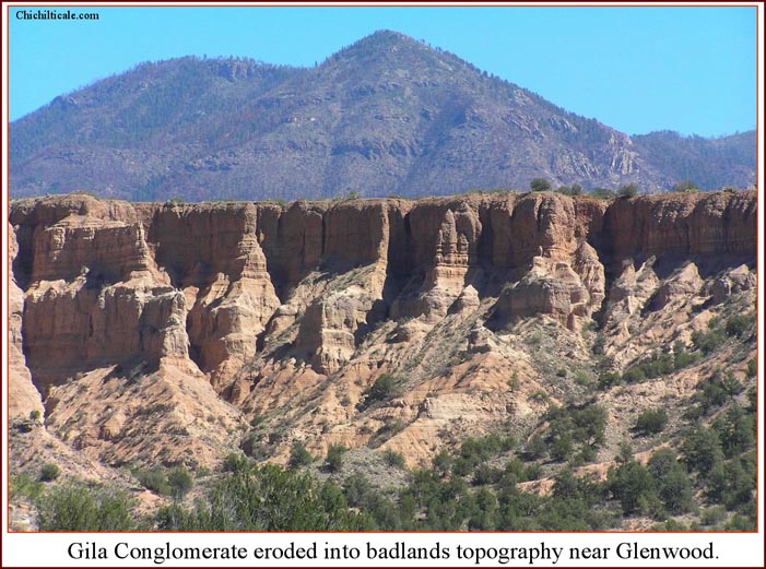
I interpret this passage to be Jaramillo's recollection of the landscape between the modern Río Gila (Río San Juan of Coronado) at Hidden Valley, New Mexico and the modern Río San Francisco (Río Balsas of Coronado) at Alma, New Mexico. One stretch of this proposed northbound Coronado Trail passes around Chocolate Mountain, then crosses the flat Mule Creek savanna to Little Dry Creek, the southern edge of what Jaramillo called the tierra doblada, and what pioneer ranchers refer to as the Cedar Breaks. This tierra doblada, up-and-down or doubled-over terrain, was caused by extreme erosion creating deep cuts in the landscape. The scarcity of flat land causes travelers to continually climb and drop, to move up-and-down more than along a lateral course.(4)
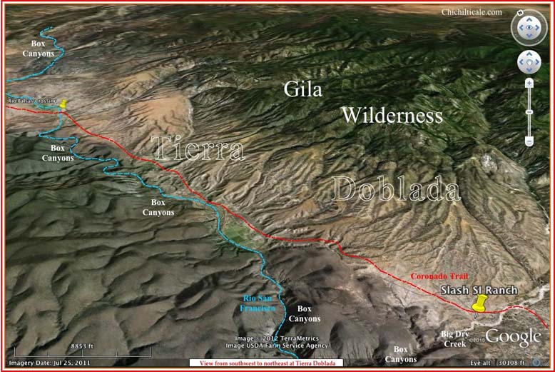
My proposed trace of Coronado's route through the tierra doblada suggested a campsite at Big Dry Creek on the historic Slash SI Ranch. Beginning in June 2010, our exploration team focused on this prospect, and we discovered convincing material evidence of the expedition there. Following my established custom, this account will present only heretofore unpublished material, so readers are directed to my earlier reports for background. This report is intended to provide information about field exploration from June 2010 through May 2011, and is current to March 2013.(5)
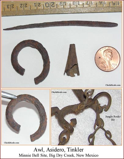
On 20 June 2010, Big Dry Creek landowner Kenny Sutton and I conducted a "swing-stick" (handheld) metal detector reconnaissance near the historic Slash SI Ranch headquarters. The test site was selected based on surface geology; subsequently Sutton arranged permission to explore on the private land. Sutton found an 8.5 cm long, quadrilateral, iron awl buried directly beside a Mimbres black-on-white potsherd. I considered the June experimental metal detecting successful in showing that the terrain could be effectively explored in such a manner, so I obtained landowner permission to conduct a wide-ranging field study.
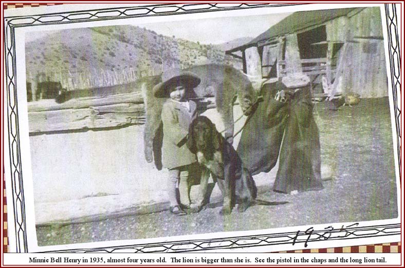
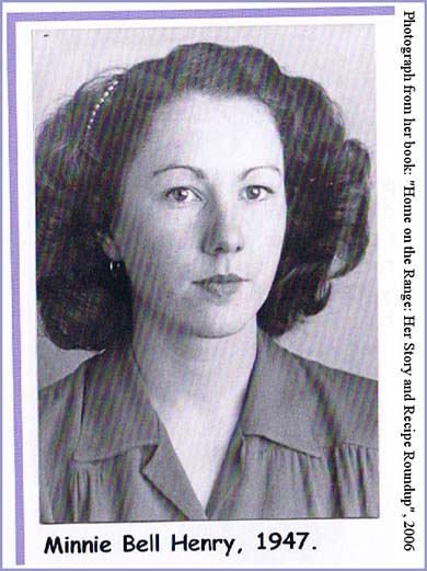
Native pioneer and author Minnie Bell Henry Hudson, daughter of James and Violet Henry, was two years old when she arrived at the Slash SI Ranch headquarters in 1933. She lived on that property and adjoining property until 1990, when she sold her historic ranch and moved to a nearby property on private land at Cactus Flat, her present home. Beginning in October 2010, Minnie Bell, for whom this site is named, and how she will be respectfully recognized throughout this report, tirelessly and resolutely began to guide me through the landscape of her lifetime, where she rode a horse, worked cattle, and followed striker hounds. She was authoritative in locating known historical sites recorded in written and oral history, such as Soldier's Hill, and notable homesteads and landmarks, and in tracing the extinct trails and roads, and in guiding me to places that could only be known by a native. Her immeasurable contribution elevated my confidence in our conclusions.(6)
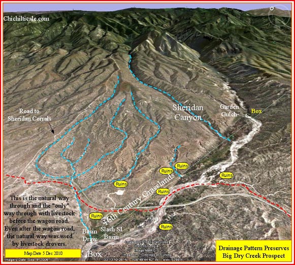
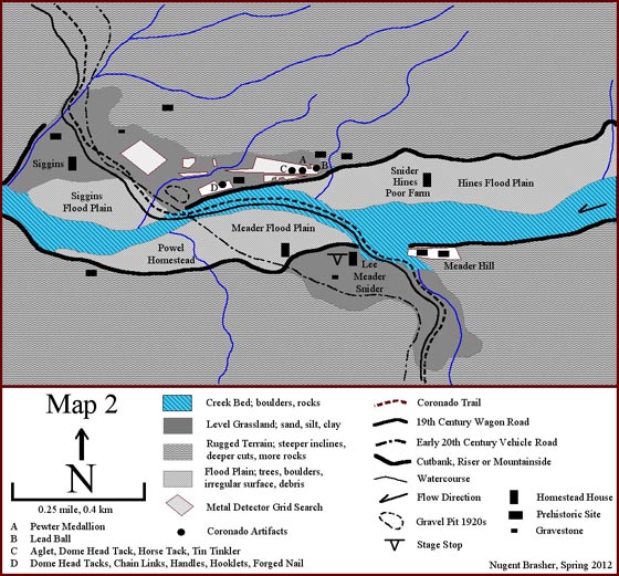
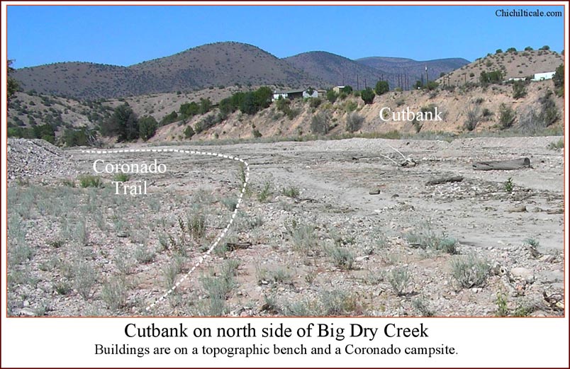
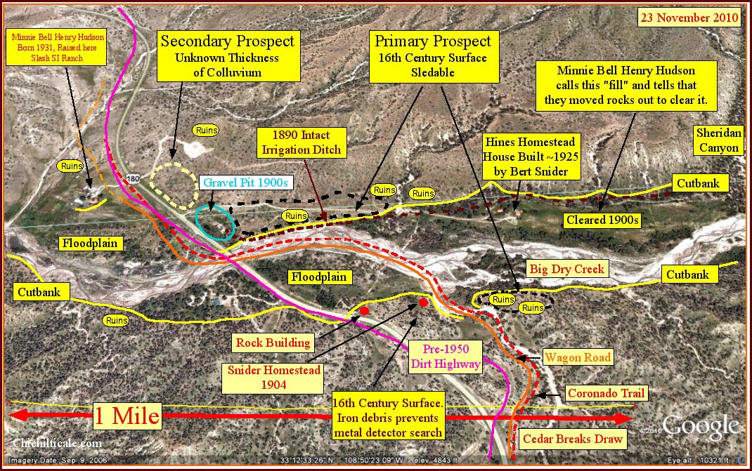
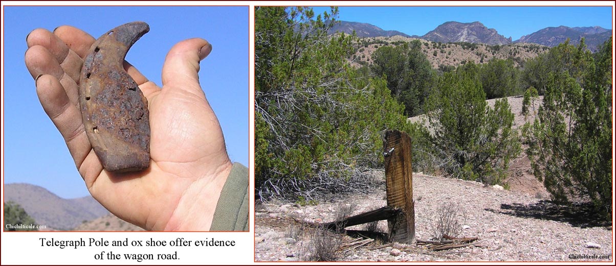
One of the team’s first tasks was to trace the most likely route of Coronado’s entry into the Cedar Breaks to reach Big Dry Creek. From Minnie Bell I learned that four roads through the Breaks had existed at various times. The wagon road was the earliest, except, of course, for the pre-historic foot trail. Along many stretches, the foot trail offered a suitable trace for wagons and livestock, so the trails lay together. The wagon road was also used by the first automobiles that appeared in 1907. Next in decreasing age was the unpaved motor vehicle road completed in the 1920s, its course closely aligned with the wagon road. Then came the first paved road for vehicles, built in the early 1950s, and, afterwards and finally, the modern paved highway, constructed in the 1990s. I hypothesized that Coronado in 1540 might have followed the route of the 350-year later wagon road through the Breaks, especially if that trace followed the path of least resistance for livestock. Beginning on the south where the route passed through a natural cut to “fall off” into the Breaks, the northbound wagon road descended into a basin of rugged terrain and eventually reached a small flat above the flood plain on the south side of Big Dry Creek and on the west side of Cedar Breaks Draw. Beginning in the 1880’s, first the Lee, and then the Meader wagon and stage stop occupied the flat. There the northbound wagon road entered Big Dry Creek and turned downstream to the west, passing beneath a steep cutbank on the north until it reached the terminus of that cliff, where the road ascended a gentle rise to the north bank of the waterway. From there the trace crossed level land to the historic Slash SI Ranch headquarters, founded in the early 1880’s, and on northward to the rim of the basin, where it ascended through a natural cut to "rim out" on the higher flats.(7)
The northbound wagon road followed an "only" trail – it entered the southern end of the basin through the only traversable natural cut and it traced the only semi-level route through the rugged terrain squeezed between the towering Mogollon Mountains on the east and the sheer walls of the Río San Francisco canyon on the west. The exit of the northbound wagon road did not, however, use the natural cut on the north side of the basin. Instead it used a manmade slope; antecedent or subsequent livestock herds, which always used the natural cut, did not use this artificial grade. With the exception of the exit, the northbound wagon road, like the Coronado Trail at its Río Gila (Río San Juan) and Río San Francisco (Río Balsas) crossings, offered the only practical way through for parties driving livestock.
The prehistoric foot trail and the wagon road are together at Big Dry Creek, where exists an attractive campsite. The abundance of chipped, black obsidian on the north bank topographic bench of the creek indicates a prehistoric Indian camp, and the several nearby pithouse and masonry ruins, some containing potsherds, suggest a permanent, or at least a seasonal, occupation site. Like the Indians before, stage station operators Lee and Meader, rancher Siggins, and Federal soldiers recognized the Big Dry Creek spot as a building location and campground. We have found evidence that Coronado almost certainly saw a good campsite there.(8)
Exploration Model at Big Dry Creek
Most archaeological solutions begin with a geoarchaeological problem. Of foremost consideration was to determine where a sixteenth-century surface remained undisturbed and available to metal detector exploration. Using field reconnaissance, satellite imagery of the landscape, and topographic mapping, I developed a geological model that emphasized the locations of sixteenth-century surfaces, as well as provided a prediction of where sixteenth-century surfaces are only slightly covered with more recent sediments.
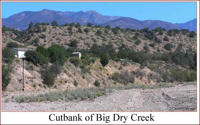
The geology of the Slash SI Ranch Prospect is dominated by Big Dry Creek. The cutbanks of the creek define the water corridor that contains stream channels and floodplains. Sixteenth-century campsites that would have been subsequently cut by stream channels or covered by flood plain sediments are unlikely to contain artifacts that can be detected and recovered – the artifacts have been either transported away or buried beyond metal detection depth. Respecting that efficient exploration should avoid prospects that have a high risk of failure, we recognized that initial prospecting should focus on areas outside the water corridor. Such surfaces include mountainsides and benches above the cutbanks. Mountainsides are not favorable campsites or artifact containers because of rugged, rocky terrain and irregular surfaces cut by drainage. Geomorphic benches are favorable campsites and artifact containers because they are level and have not been covered by thick colluvium from the mountainsides or cut by drainage. Benches offer the most favorable prospecting surface on the Slash SI Ranch prospect.
The most prospective sixteenth-century surface at the Slash SI Ranch prospect is on a geomorphic bench on the north side of Big Dry Creek. This bench is bounded on the south by the northern cutbank of the creek, on the east by the Hines floodplain, on the west by the Siggins floodplain, and on the north by the mountainside. This surface has not been flooded, and has been only slightly eroded by wind and rain since the sixteenth-century. Such conditions are conducive for cultural material to be at or near the surface. There are two additional sixteenth-century surfaces of interest in the prospect. The stage station was built on a geomorphic bench favorable to preserving Coronado-era artifacts. Unfortunately, effective metal detector exploration on that surface is severely impeded by copious amounts of metallic homesteader debris. East of the stage station is flat-topped Meader Hill, where ruins of a masonry building and numerous obsidian chips are present. Although the hilltop is not directly beside a water source, it is nevertheless a favorable campsite because of vantage, fuelwood, shade, and level, soil-covered ground. The landform is advantageous to retaining sixteenth-century material because of lack of deposition or fluvial erosion of that surface. We considered Meader Hill a worthy prospect.
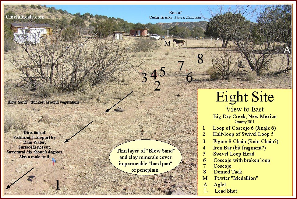
Coupled with the geological model, I used the historical information presented in the following section to develop a human-presence model consisting of trails, campsites and prehistoric ruins. Then I turned toward consideration of the Coronado travelers themselves. As I reconstruct events, the following army of the Coronado Expedition reached Big Dry Creek via the subsequent 1800s wagon road alignment. The travelers turned downstream and reached the western end of the cutbank near the 1900s gravel pit. There they turned north, climbing out of the creek. The time to initiate camp selection for northbound expeditionaries was after the travelers ascended from the creekbed and looked around. They saw grasslands on level terrain all around them. Water flowed and pooled in the creek.
As more travelers arrived, word spread that the campsites south of Big Dry should be used because northern camps were occupied. This put Coronado expeditionaries on the future stage station and Snider homestead sites, and in the grasslands along and near Cedar Breaks Draw nearest Big Dry Creek. Some travelers selected the flat top of Meader Hill and others camped in the water corridor of Big Dry Creek. Farriers might have chosen the creekbed because of the water and firewood they required. Almost all travelers would have used the creek for livestock and human water consumption. The southbound retreating army would have selected similar campsites, using perhaps even more spots along Cedar Breaks Draw than had the following army.
Employing these geological and human-presence concepts, I generated an exploration model that directed the initial focus of our search – we first looked on surfaces that were little altered since 1540, such as land that had not been eroded or flooded, and at places on this surface that best fit my instinct and considered notion of where campsites for large groups might have been located.
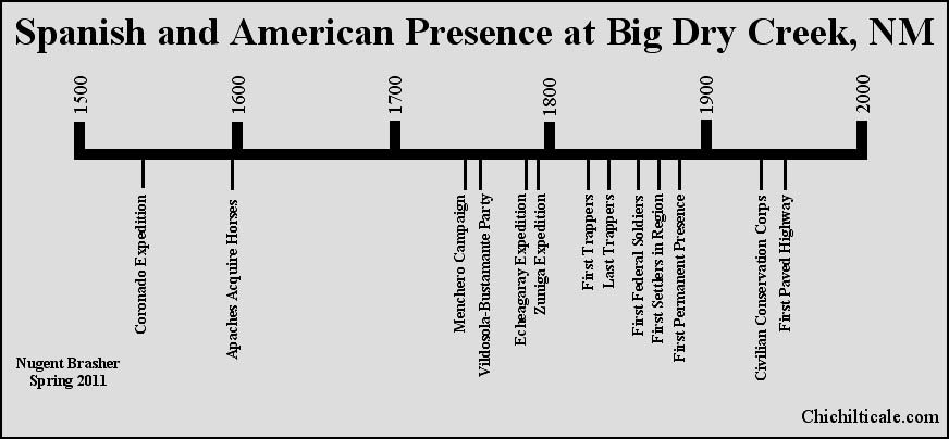
Artifact identification demands an historical framework. Using the results of historical research, I will provide a chronology of presence in the region. This will demonstrate that Native Americans, Europeans, Mountain Men, scalp hunters, Federal soldiers and American settlers were at Big Dry Creek. Consequently, all these potential artifact bearers must be considered when proposing a date for objects found there.
Trade trails pass through and connect settlements. I have previously presented a map of prehistoric communities that I suggest offers the trace of the trade trail followed by Coronado. Even though Coronado reported despoblado, he was almost certainly moving along a trail that had once connected occupied settlements and that was still used by Native American long distance travelers and nomadic bands. In 1539, however, a new herd of travelers appeared along the trail when Franciscan friar Marcos de Niza from Nice, France, at that time controlled by the Italian House of Savoy, and Esteban de Dorantes from Morocco ventured toward Cíbola, subsequently followed by the expeditionaries of Coronado, all these travelers being Europeans and Africans driving domestic animals. Because of the constraint created by the livestock, not all sections of the prehistoric foot trail were suitable, so selection of a specific path was based on accommodation of livestock. For example, while some Native American groups might select a foot trail along a river through a walled chasm, the expedition likely avoided box canyons that offered no escape and where livestock travel was difficult because of rocks and vegetation. The path of least resistance is not the same for foot travelers, horsemen and drovers.(9)
The Coronado Expedition made the first livestock drive from Mexico to Kansas, so the Coronado Trail was the first “cattle trail.” The Coronado drovers were the first contingent of Old World natives to travel this ancient trade road, thereby offering the most likely earliest opportunity for European or African products to appear along the trail. Afterwards, other Old World travelers followed. Paramount to dating metal objects found in the tierra doblada region is convincing determination of whether the artifact under examination resulted from the Coronado Expedition, or was dropped by subsequent Europeans, European-Americans or Native Americans. Written history assists in that determination.
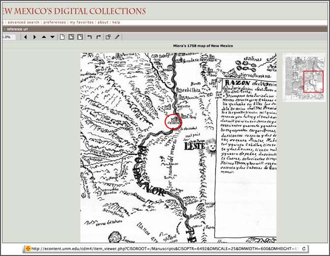
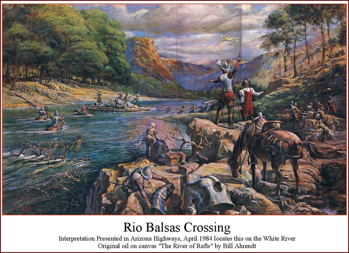
After Coronado departed in 1542, Spaniards next returned to Big Dry Creek in the autumn of 1747 with “The Great Campaign,” as that adventure was tagged. Captain Alonso Victores Rubí de Celís, the presidial commander at El Paso, was commander-in-chief of the seven hundred man force of Spaniards and Indian allies and their herd of over one thousand remount horses. Friar Juan Miguel Menchero served as Chaplain and military adviser – for this the adventure was called by the people “Father Menchero’s Campaign.” Famed cartographer Bernardo de Miera y Pacheco accompanied the expedition and charted the route. Historian John L. Kessell reports that Miera’s original map has not “come to light.” Little detail of the route was offered in an early 1760s report provided by Bishop Pedro Tamarón y Romeral. The Bishop mentioned only that “From the Jornada del Muerto [the expedition] turned west in search of the Gila River. They reached it and made some forays into those vast lands.. They returned toward the north and reached the direct way to and the latitude of New Mexico… .” (10)
Some thirty years after the campaign, in 1775, Fray Silvestre Vélez de Escalante, in his letter of 28 October 1775 to Gov. Pedro Fermín de Mendinueta, reported what he had learned about the route from Zuni to Sonora. (See Appendix I.) Based on information acquired from Miera y Pacheco and from Zuni Indians, Escalante described the trail:
“… by traveling 4 days towards the south from this pueblo of Zuni, one encounters a small river, which during this (1747) campaign they named the San Francisco. It is formed by two streams, of which the one runs from northeast to southwest and the other from north to south. The latter is slightly larger than the former. By means of [this river's] trough (caja) one traverses the Gila Mountains with ease. Together [these two streams] form the aforesaid San Francisco River, which within the canyon through the mountain range continues a course from north to south. When [the canyon] ends, it takes a course to the west.” (11)
This description fits the drainage and terrain of the combined Río Tularosa and Río San Francisco. Four days by horse south of Zuni, via Hardcastle Gap, are the headwaters of the Río Tularosa, at that spot a small stream flowing northeast to southwest. Just south of Reserve, New Mexico the southwest flowing Río San Francisco joins that stream, claiming the name and continuing to the southwest. Just north of Alma, New Mexico, west flowing Deep Creek and south flowing Pueblo Creek join the Río San Francisco, creating a still larger drainage. The river turns sharply to the south there and flows north to south through narrow box canyons. At Big Dry Creek the Río San Francisco veers sharply to the west, continuing through a box canyon. Given this description, it is more likely than not that the Menchero Campaign was at Big Dry Creek about two hundred and ten years after Coronado had departed. These middle eighteenth-century Spaniards were the first Europeans of currently retrieved written record that could have deposited European products at Big Dry Creek after 1542.(12)
In late November of 1756, a military party numbering over 300 fighting Spaniards and Indian allies camped at Todos Santos, on the Río Gila near modern-day Cliff, New Mexico. The party was composed of the combined forces of Spaniards from Sonora under the command of Captain Gabriel Antonio de Vildósola, and Spaniards from Chihuahua commanded by Captain Bernardo Antonio de Bustamante y Tagle. Father Bartolomé Sáenz represented the Church, and it is his account that has survived for the record. Captains Vildósola and Bustamante sent an exploratory detachment from Todos Santos to the Río San Francisco. Kessell recounts the events surrounding the unit’s mission:
“At this point a detachment set out to the north for the Río de San Francisco to find out if by following its bed or banks one could get through either to the northeast, the direction from which it flows, or to the west, toward which it runs. It was found impassable in either direction because of the narrow gorge between sheer crags of great height along its banks. During this journey from one river (Río Gila) to the other (Río San Francisco), some twenty leagues…”(13)
This description of the landscape fits the box canyons at the intersection of Big Dry Creek and the Río San Francisco, where the south flowing river bends sharply to the west to avoid Outlaw Mountain. I consider it likely that the detachment visited the Slash SI Ranch site. The number of soldiers in the exploratory unit is unknown to me, as is their duration at the site; detachments commonly numbered forty to sixty men. My presumption is a one-night stay by about fifty troops. This military party represented the second Spanish presence at Big Dry Creek since Coronado, and these soldiers could have left artifacts there.
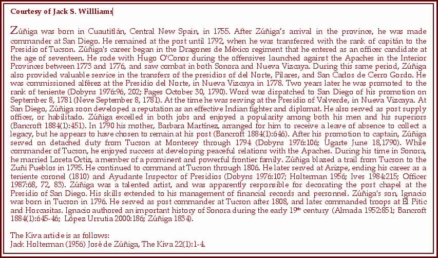
During the last quarter of the eighteenth-century, about two hundred-fifty years after Coronado, two major Spanish military expeditions reached Big Dry Creek. The first of these was commanded by Don Manuel de Echeagaray in 1788, who directed 280 leatherjackets and 120 presidio men, and the second was led by Captain José de Zúńiga in 1795, who directed 151 soldiers and Apaches. Although the cardinal purpose of these campaigns was to find a road from Tucson, Arizona to Zuni, New Mexico, the Spaniards, nevertheless, devoted considerable energy to warfare with the Apaches, attesting to the fact that these Native Americans were present in the tierra doblada. These late eighteenth-century Spaniards could have deposited European products at Big Dry Creek.(14)
The totality of these Spanish, Zuni and Pima routes strongly support my contention that Coronado proceeded along an old and favored trail, one that was followed before him, and continued in use long after he had gone.
The Apaches, of course, remained in tierra doblada after the Spaniards departed in 1795. Beginning in 1815, Apache chieftain Mangas Coloradas used Santa Lucia Springs (modern-day Mangas Springs) as his home, effectively buffering Big Dry Creek from intrusion from the south. Except for the beaver trapping period from about 1825 to 1838, the Apaches enjoyed tierra doblada by themselves. While Mountain Men appeared in the middle 1820s, and although warfare erupted in 1831 when the Apaches and the Mexicans forsake an uneasy peace, beaver trapping in the Río San Francisco region continued. However, in 1837 the mercenary John Johnson befriended and then massacred a group of Apaches in the Animas Mountains, setting off a series of events, including the seizure and warning of trappers, that led to the virtual abandonment of the Santa Rita mines in 1838. The loss of Santa Rita as a trapper supply and storage center, coupled with the economic collapse of trapping caused by depletion of the beaver and the style change from beaver to silk hats, prompted most of the Mountain Men who had not already fled because of the Apache warnings to withdraw that year.(15)
Federal soldiers hunting Apaches likely visited Big Dry Creek in 1856 and 1857. In February 1856, troops commanded by Captain Daniel T. Chandler departed from Fort Craig on the Río Grande south of Socorro for the Río Tularosa near Aragon and Reserve, where they turned south and skirted the western flank of the Mogollon Mountains to arrive at Buckhorn, New Mexico in middle March. There they joined troops arriving from Fort Thorn, also on the Río Grande, that had passed through the Santa Rita copper mines near modern Silver City, thence to Santa Lucía Springs at modern Mangas Springs, thence to modern Cliff, where they crossed the Río Gila and marched to Buckhorn. Because of their likely route, it is almost certain that Capt. Chandler's troops rested or camped at Big Dry Creek. The following year in May, Colonel William Wing Loring led five companies from Albuquerque to the Río Tularosa, thence to a depot at Greenwood Canyon near modern Riverside, New Mexico on the Río Gila. There they joined forces with soldiers from Fort Thorn and Fort Buchanan to launch a campaign against the Apaches that endured into July. This grandiose operation, named the Bonneville Campaign after its commanding officer Colonel Benjamin Louis Eulalie Bonneville, was the first and last of its kind in Apache warfare. Colonel Loring's troops also very likely rested or camped at Big Dry Creek on their southward approach to the Depot at Greenwood Canyon.(16)
Following the American Civil War, settlers and soldiers began to appear in the Río San Francisco valley. Soldiers from Fort Bayard in the south, established in 1866, and Fort Tularosa in the north, built in 1872, began reconnaissance patrols in the valley. Also passing through by the late 1860s were Mormons herding cattle south from Utah to the trailhead at Cliff, thence to Mexico. These drovers built some sojourner cabins at Upper Frisco Plaza near modern-day Reserve. Permanent settlers arrived soon thereafter. Fort Tularosa, located near contemporary Aragon, New Mexico, was abandoned in 1874. That year two ex-soldiers, Patrick H. Kelly and Patrick Higgins, established homesteads on a plaza north of present day Alma, where they raised sheep and sent the wool to Socorro, New Mexico for sale. Also arriving in the Río San Francisco valley that year was Seńor Sarracińo. These three were the first permanent non-Native settlers in the Río San Francisco valley south of the Mormon cabins at Upper Frisco Plaza. That same year of 1874, Sergeant James Cooney was sent from Fort Bayard to conduct a mineral survey in the Mogollon Country. As a consequence of favorable signs of valuable metals, Cooney returned to the valley in 1876 and established a mining operation on present-day Mineral Creek, first called Cooney and later Canon City. Miners soon arrived and the camps boomed. In 1878 the permanent and enduring settlements of Alma, Glenwood and Pleasanton were founded.
Important for interpreting the ages of artifacts found specifically at Big Dry Creek is to know when American settlers first arrived there. (See Appendix II.) It is likely that Big Dry Creek was a reststop for freight wagons along the road from Silver City to Cooney by 1876, prior to the first buildings on the spot. Traffic increased. Postal service was established in Clairemont, near Cooney, in 1881. The following year a post office was opened in Alma when that settlement was included in the northbound tri-weekly mail run from Silver City. Issac Siggins had founded his ranch on Big Dry Creek before July 1884. By 1885 a constant stage service was in place, the coaches requiring only eight hours riding time between Silver City and Alma. This increasing traffic warranted a station operation on Big Dry Creek. The John D. Lee House & Stage Station appeared before 1889. My exploration model presumes that iron artifacts associated with wagons and homesteaders had appeared at the site of the wagon stop on Big Dry Creek by 1876, and that their numbers increased dramatically thereafter. (17)
As a corollary to this record of historical occupation, cultural evidence of Europeans, Apaches, Mountain Men, scalp hunters, Federal soldiers and American settlers should not be unexpected at Big Dry Creek.(18)

Native Americans on horseback appeared in the very early stages of the colonial period. Historian Richard Flint points out that in late 1539, Don Martín Guavzin or Tlacatecatl, a principal from Tlatelolco and member of the Coronado Expedition, traveled by horse to rendezvous at Compostela. Six days westbound from Mexico City, Don Martín fell from his horse and broke his arm. As a result, he returned home to Tlatelolco, taking many of his subordinate warriors with him. This is one of many examples of the privilege of riding a horse being conferred on converted Native Americans. It was otherwise against the law for indios to ride horses. Of course, this regulation could be enforced only on conquered Native Americans, and, as a consequence, it was not uncommon for gente de guerra or indios bárbaros to obtain and ride horses prior to indios de paz.(19)
Addressing the likilihood of horses from the Coronado expedition providing mounts for Native Americans, Richard Flint wrote that he feels, “… quite confident of (and is in agreement with most other historians about), is that none of the wild horses in the Southwest derive from the Coronado expedition. The horsemen were all mounted on geldings, and there was only one known mare. Quite a number of horses died during the course of the expedition, but we don't know of any live ones that got away. Even it a few did, they were almost certainly all males. Historians are generally agreed that both wild and domestic herds that survive until today in the Southwest descend from stock that came north with Ońate and afterwards or were introduced much later by Anglo-Americans.”
During the 1542 Mixtón War, the Spaniards taught their Native American allies to ride. The inevitable occurred immediately when mounted Native Americans on stolen horses began raiding the Spaniards themselves. The Native Americans initially stole horses and cultivated ramudas, but by 1579 there were large numbers of wild horses and mares in ever enlarging herds, so it was no longer essential to obtain stock by force. The Chichimec War period of 1550 – 1600 caused rapid northward expansion of the mounted Native American. The 1590 expeditionary site of Gaspar Castańo de Sosa discovered near modern-day Carlsbad, New Mexico was a very large corral supposedly used for ganado (cattle, sometimes including sheep), although it could also have corralled horses, or even have been a game trap. During the return of that failed expedition to New Spain in 1591, Native Americans near modern-day Las Cruces, New Mexico attempted to steal horses. These incidents offer evidence that by 1590 Native Americans in New Mexico certainly desired to have horses and may have already possessed them.
Shortly thereafter these Native Americans achieved their ambition of becoming mounted raiders. If they had not already obtained horses from the south, the arrival of colonist Don Juan de Ońate in New Mexico brought horses to them. Ońate's pioneers of 1598 soon put Native Americans to work as shepherds, and some of these livestock stewards fled and took animals with them, thereby providing horses to Native Americans soon after the coming of the Spaniards. Within eight years of Ońate's arrival in New Mexico, raids by mounted Native Americans were first recorded. Historian Donald E. Worcester provides documents and interpretation showing that "Apaches began acquiring horses as soon as there were any to be had" and that "Ońate's first settlement was soon the target" of Apache raids. Livestock theft in Río Arriba was a serious problem by 1608. That year Father Lázaro Ximénez complained to the viceroy that Apaches were stealing the Spaniards' horses. Historian Jack D. Forbes writes that between the years 1610-1621, "…all of the Athabascans ("Apaches") in the New Mexico area must have acquired horses.”(20)
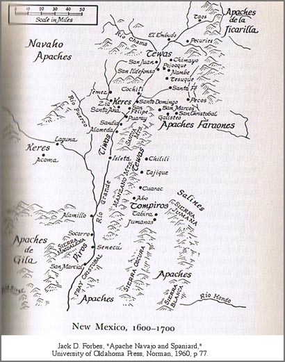
After the arrival of Ońate, conflict between Spaniards and Apaches intensified, as did Apache raiding. By the 1620s, and probably earlier still, the Spaniards were aware of Apaches in the Gila region. Father Alonso de Benavides described the Indians of the regions of New Mexico, and he distinguished between the Xila (Gila) Apaches and the Perrillo (Mescalero) Apaches by claiming that the Gila Apaches lived west of the Río Grande. Benavides described the territory of the western group of the “Grand Nation of the Apaches” as:
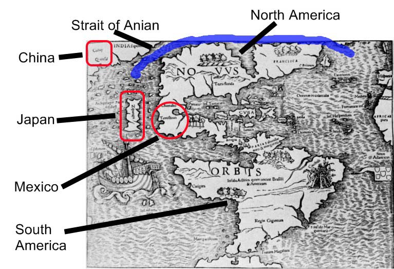
“When we go to New Mexico, starting from the beginning of it [the Apache nation], which is the province of the Perrillo Apaches, it [the nation] runs through that area toward the west as far as the Mar del Sur (Pacific Ocean), in which there is more than three hundred leagues. And it [the nation] continues toward the north without our having found its end there. And it [the nation] runs into the Strait of Anian (Bering Strait).”
Specific to the Gila Apaches, Benavides writes that the Apaches nearest the Perrillo were “the Apaches de Xila, fourteen leagues from the pueblo of San Antonio de Senecú de la Provencia de los Piros.” Senecú is considered to be near San Antonio, New Mexico, south of Socorro. If so, this description, depending upon the distance used to define a league, and upon which direction is chosen, locates Xila Apaches in the 1620s some forty to seventy miles west of Senecú. This expanse includes the mountains of southwestern Socorro county, easternmost Catron county, and the Plains of San Augustine, all part of Apachería.(21)
My exploration model includes the presumption that upon the arrival of mounted Europeans to the Chihuahuan and Sonoran deserts and to Río Arriba, Apaches targeted this new group for rustling and enjoyed instant success. Immediately mounted raiding commenced using stolen technology – the horse. Raiding increased through time. It follows that plunder would appear immediately in Apachería. As the Spaniards moved northward from central Mexico, the quantity and types of European products increased in the Apache region. This influx of exotic material to Apachería complicates assignment of European artifacts solely to European bearers – Apaches could have brought an object to where it was recently found.(22)
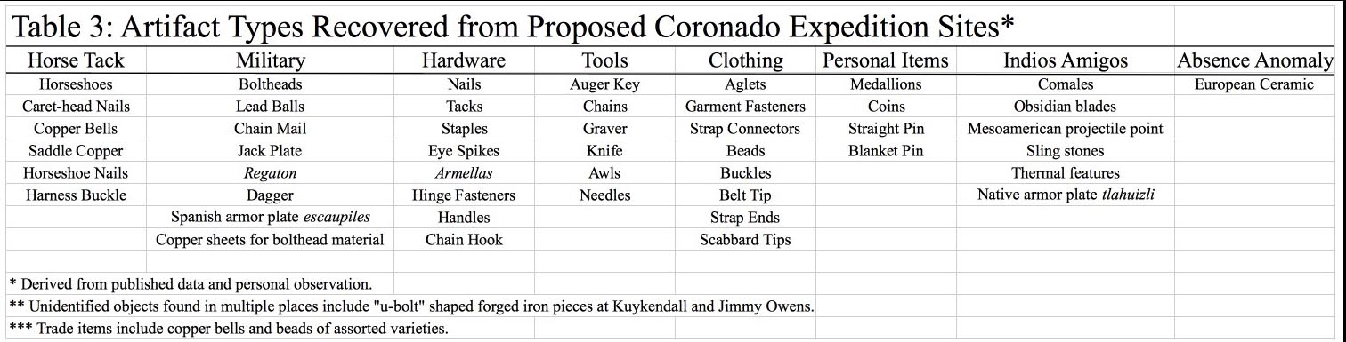
Evidence of Apache raiding of Europeans can be demonstrated by assigning an artifact to one of two populations. One artifact population is associated with locations of reported or interpreted Spanish presence. The contrasting population is composed of pieces that are associated with little or no reported Spanish presence. Archaeological researcher John H. Madsen presented a map in 2003 showing the locations of reported Spanish artifacts. I generated a map of reported Spanish presence. One of the measures I used to define Spanish presence was the cartography of historian Alfred B. Thomas, who published a map of Spanish military excursions in southwestern New Mexico and southeastern Arizona from 1779 to 1785. The map shows the concentration of these patrols to be in the Bootheel region of New Mexico and the San Bernardino – San Simon valleys of Arizona. I observed that of twenty-one Spanish artifacts shown by Madsen, all but two came from areas of reported Spanish presence. Attesting to this strong Spanish presence mapped by Thomas are Spanish artifacts contained in private collections that were recovered from the Peloncillo Mountains. Some of these pieces were shown to the organizers of the "Coronado Road Shows" in 2004 .(23)
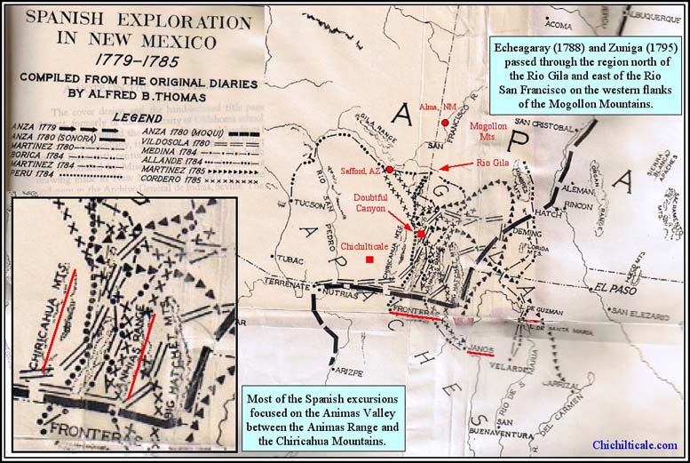
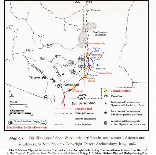
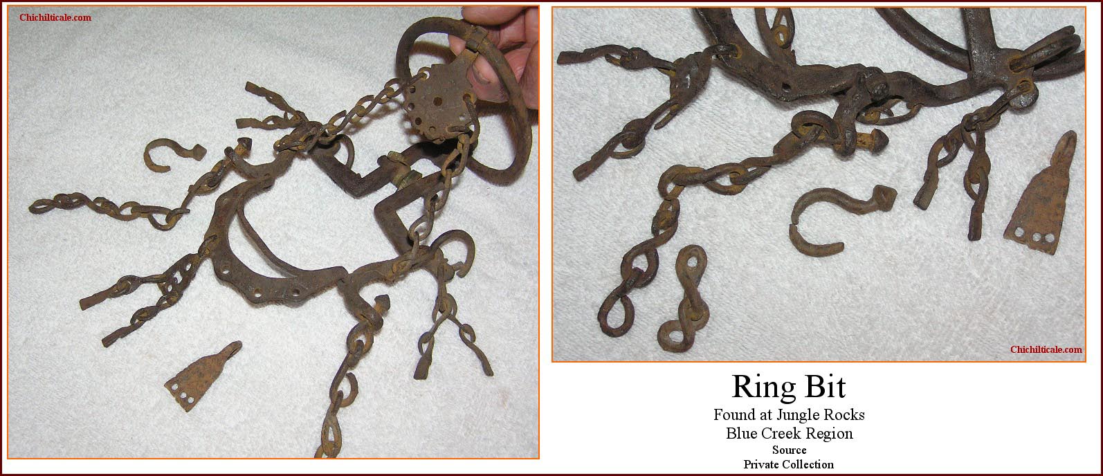
There are additional artifacts to consider. I have examined private collections and can report that Spanish colonial artifacts from the Blue Creek region north of the Río Gila in southwestern New Mexico include spurs, stirrups, bits, buckles and copper utensils. Most of these pieces, but not all, were found in extremely remote locations off main trails, suggesting an Apache bearer rather than a Spaniard. The Blue Creek region almost certainly lies outside Spanish presence between 1542 and, perhaps 1747 or 1784, maybe even 1788 – Thomas' map shows only one 1779 to 1785 patrol, a 1784 excursion, reaching as far north as the Río Gila in New Mexico. I have pointed out that the Spaniards in Sonora did not return to the region north of the Río Gila after Coronado until brief excursions in 1747, 1756, 1788 and 1795. Thomas does not include these four expeditions on his map. Madsen's map shows two Spanish artifacts outside the region of intense Spanish presence. I interpret his map to show that one of these is located approximately fifteen miles east of Cliff, New Mexico. The other is shown about ten miles southeast of the conflux of Big Dry Creek with the Río San Francisco; since I interpret that the 1747, 1756, 1788 and 1795 expeditions visited Big Dry Creek, this particular artifact might be from one of those excursions. Or it might have been brought there by an Apache.(24)
One specific Blue Creek region buckle merits special mention. This piece was found on the north side of the Río Gila a short distance from Hidden Valley, the site I have proposed as Coronado’s advance party camp of 24 June 1540, as well as a camp for the following and retreating armies. About the artifact, John Powell, a St. Augustine, Florida curator, conservator, and authority on Spanish buckles, wrote:
“This is very definitely a 16th century buckle. Its sheer weight and robust construction would tend to suggest that it is more likely an upper class harness or saddlery buckle than something worn on a sword belt or other accoutrement. The other thing that raises an eyebrow is the fact that the tine/tongue was attached to the outer edge of the buckle frame rather than to the center bar. Later Spanish accoutrement buckles were also made this way, and I’m not exactly sure how they worked. But the period during which this was made and used very nicely corresponds to that during which the Coronado/Soto expeditions took place. I have seen quite a few pieces of brass or bronze found out West with the same very dark patina this buckle exhibits. It’s very nice and very unusual.”
This buckle strengthens our exploration model by providing confidently identified sixteenth-century material evidence near Hidden Valley, a location predicted by the model to be a Coronado campsite. With this find, there is now material evidence of the Coronado Expedition at Kuykendall Ruins, Doubtful Canyon, Hidden Valley, and Big Dry Creek. My exploration model predicted all these to be Coronado camps along an ancient trail.(25)

The exploration model presumes that Spanish artifacts found in Apachería could have arrived there from New Spain to the south or from New Mexico to the east, and that their arrival from a southern source following the Coronado Expedition could have been as early as the final decades of the 1500s. Consequently, the team always considers the Apache complication when assigning pieces to a specific bearer, especially artifacts proposed to be late sixteenth-century and early seventeenth-century.
Initial metal detecting on the Minnie Bell site focused on two properties – the Kenny and Debra Luera Sutton and Marianne Sutton tract, and the Dave and Donna Olson tract – both located on the northern side of Big Dry Creek on a topographic bench overlooking the watercourse. Our exploration began 23 October 2010 on Sutton property located above the north cutbank of Big Dry Creek. Employing a Blennert sled and handheld metal detectors, the team of Minnie Bell, Loro Lorentzen and I systematically explored the Slash SI Prospect. By the spring of 2011 we had searched the available accessible portions of the Sutton and Olson tracts. We found evidence of prehistoric Native Americans, of the sixteenth-century Coronado Expedition, and of at least one of the eighteenth-century Spanish expeditions of Menchero, Vildósola–Bustamante, Echeagaray and Zúńiga. Also we found possible evidence of Mountain Men, fur trappers and scalp hunters of the 1820s to 1840s, evidence of nineteenth-century Apaches, of Federal military personnel of the last half of the nineteenth-century, and of late nineteenth-century and early twentieth-century homesteaders.
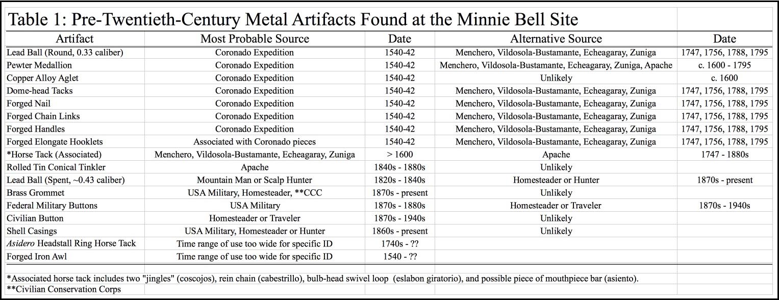
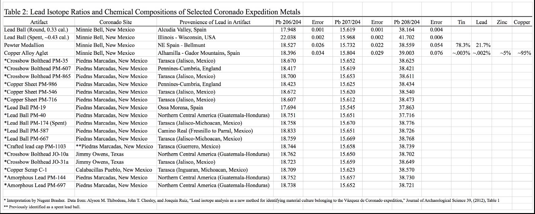
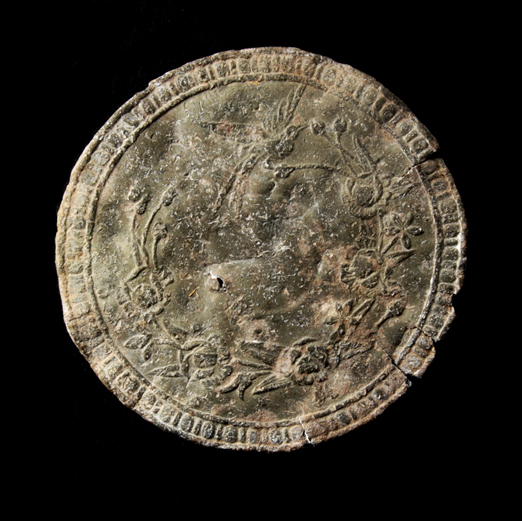
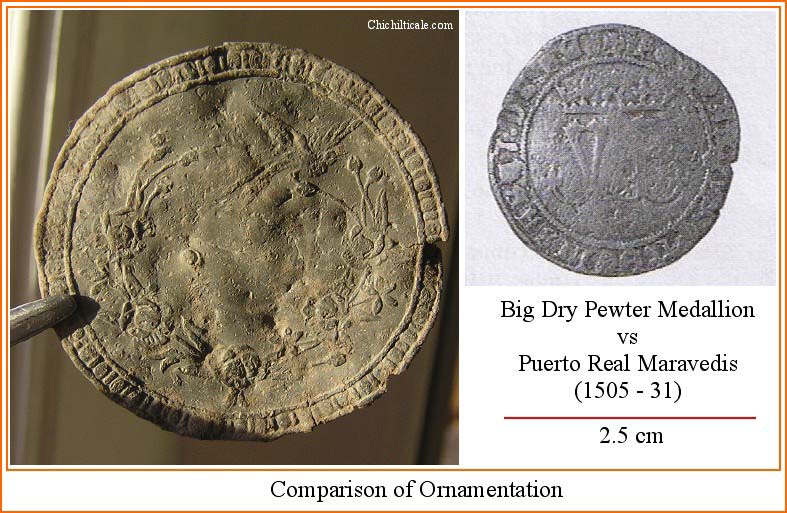
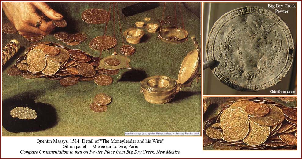
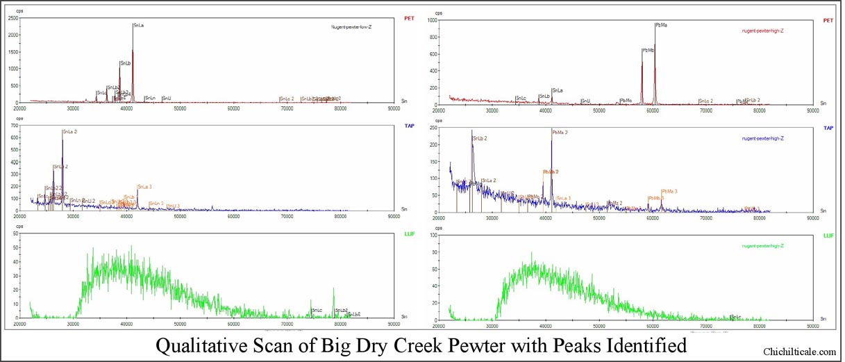
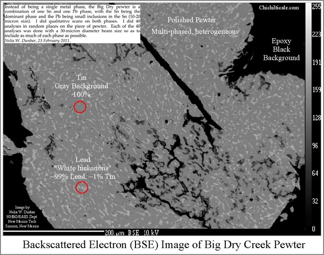
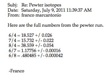
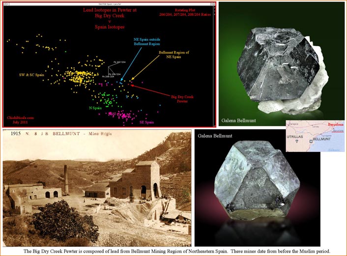
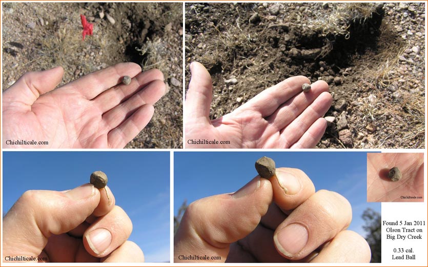
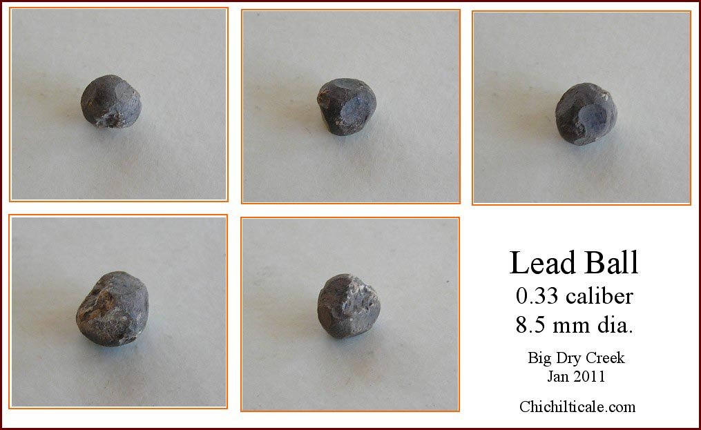
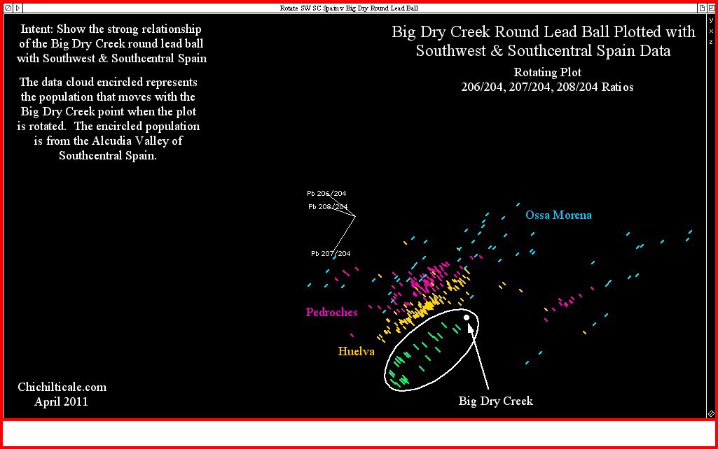
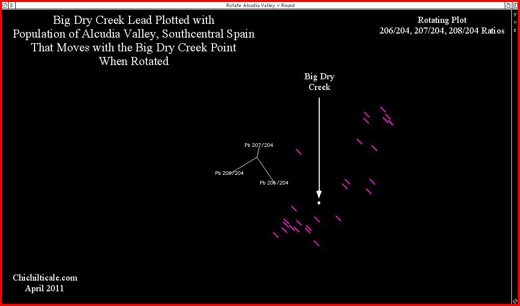
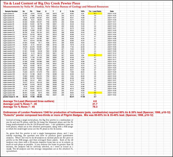
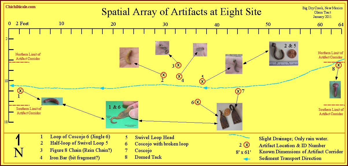
On the eastern end of the topographic bench above the northern cutbank on the Olson property the team found a pewter medallion, two lead balls, one round and one flattened, and a copper-alloy aglet. We employed electron microprobe analysis to determine that the chemical composition of the pewter medallion was 78.3% tin and 21.7% lead with no other measurable elements present. We used Thermal Ionization Mass Spectrometry (TIMS) to measure the lead isotope ratios of the lead present. Our subsequent analysis determined the source of the pewter lead was the Bellmunt region of northeastern Spain, mined since before the Muslim period. We likewise used TIMS to measure the isotope ratios of the round lead ball found 225 feet east of the pewter medallion. Based on our analysis, we confidently concluded that the source of the lead in the round ball was the Alcudia Valley of south-central Spain. Previously I have written that lead from Spain found within the Coronado travel corridor extending from Palominas, Arizona on the south to near Hawikku, New Mexico on the north is almost certainly a product of the Coronado Expedition. We consider the pewter medallion and the round lead ball to be powerful evidence supporting the presence of Capt. Gen. Francisco Vázquez de Coronado at Big Dry Creek, New Mexico.(26)


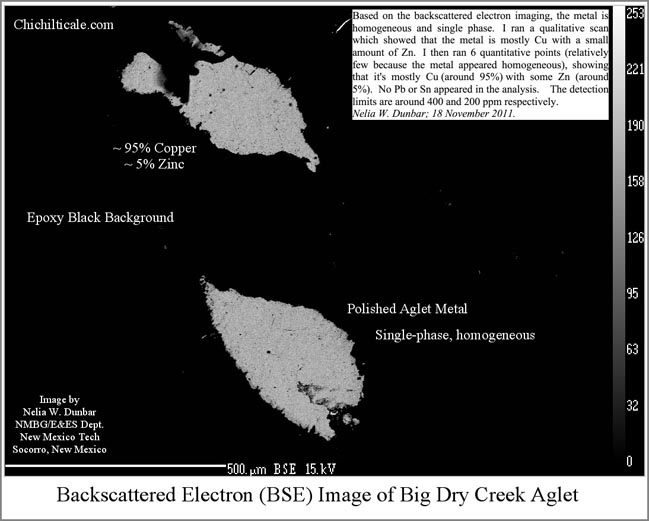
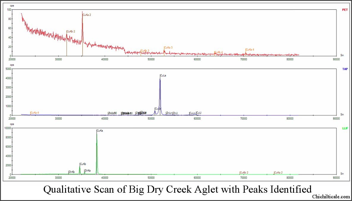
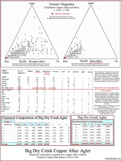
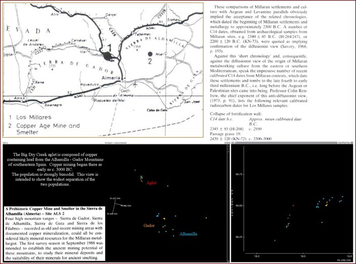
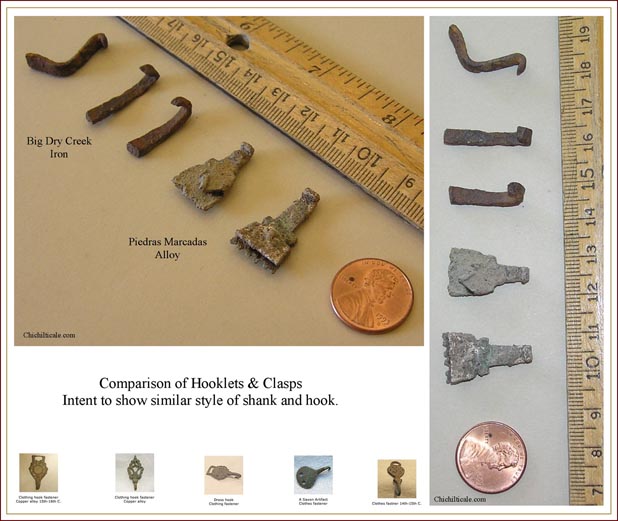
The copper alloy aglet found 135 feet southwest of the pewter medallion was discovered under a juniper tree that forced swing-stick metal detecting by Loro Lorentzen. As with the pewter medallion, we employed electron microprobe analysis to quantify the chemical composition of the alloy. The results showed ~ 95% copper and ~ 5% zinc, thereby defining the metal as “brass.” Metallurgical analysis of English lace chapes from c.1150-c.1450 demonstrated that of 53 measured, 39 were brass, 6 were bronze, and 8 were gunmetal. The Minnie Bell site aglet contained enough trace element lead for measurements of the lead isotope ratios by TIMS. We concluded the lead to be from the Alhamilla - Gador Mountains of southeastern Spain, mined for copper as early as c. 3000 BC, perhaps the oldest copper mining region of the Iberian Peninsula.(27)
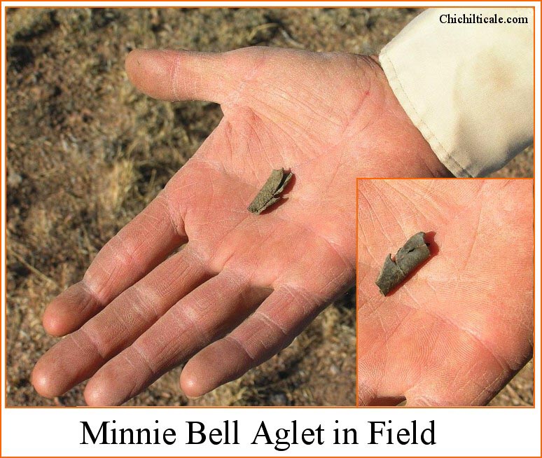
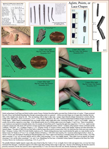
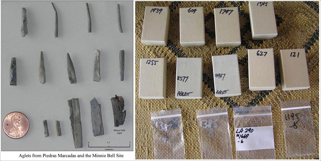

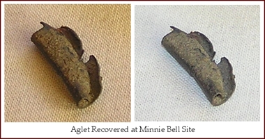
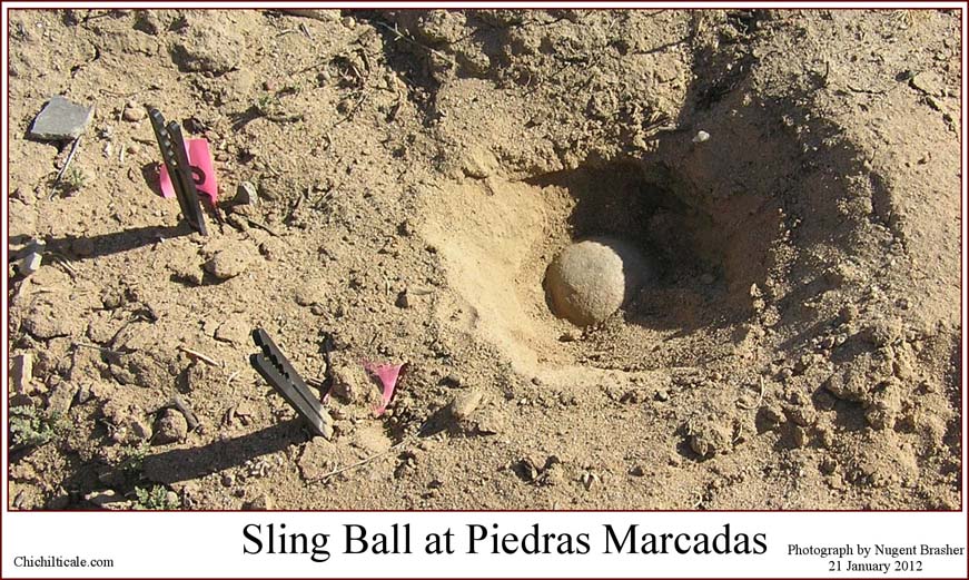
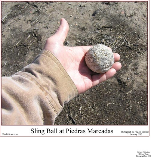
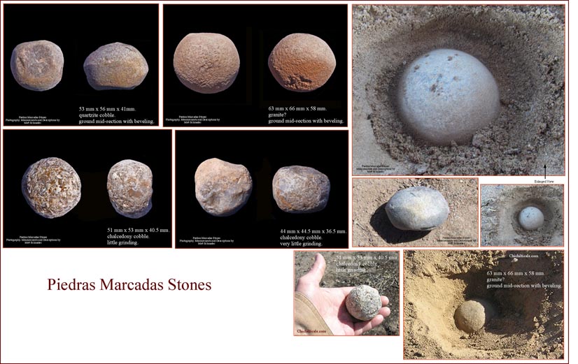
Aglets are also known as points, or lace chapes. Richard Flint described aglets: "At [Coronado] time, many components of dress were laced together, as, for instance, sleeves and a jerkin or hose and a doublet. The many laces employed were each tipped with metal cones (aglets).” Aglets have been reported at two Southwestern Coronado sites and at two isolated sites near Aztec, New Mexico. Since the 1990s, one copper and two silver aglets were recovered at the Jimmy Owens Site, and fifteen copper aglets were found at Piedras Marcadas. Aglets are temporally restricted. Archaeologist Kathleen Deagan reported, “Aglets are rare at Spanish colonial sites after about 1650 and have not been reported from eighteenth-century contexts." Hispanic Society of America costume curator Ruth Matilda Anderson believed that by the 1560s “few if any [Spanish] men were wearing" aglets. Richard Flint wrote, “Cunnington and Cunnington indicated that in Britain aglets were 'very fashionable from 1510-1640s.” If our identification is correct, and because aglets are not reported at Spanish sites after the end of the 1600s, and because there is no indication of Spanish presence in tierra doblada from 1542 until 1747, and because the lead in the aglet is of Spanish origin, then the aglet, more likely than not, reached Big Dry Creek with the Coronado travelers. We consider the aglet to be equal in importance to the round ball and the pewter medallion, all three composed of Spanish lead, as an indicator of the presence of the Coronado Expedition at the Minnie Bell site.(28)
In addition to lead isotope ratios from metallic artifacts found at the Minnie Bell site, Table 2 includes lead isotope ratios of lead objects and of trace element lead in copper objects from Piedras Marcadas and Calabacillas Pueblo, New Mexico, and the Jimmy Owens site in Texas. Previously, I have presented isotope data from Kuykendall Ruins, Doubtful Canyon, Hawikku, Piedras Marcadas, and Jimmy Owens. Our analysis of this dataset finds that source locations contributing lead shot are Spain, Central America, and Tarasca (western central Mexico). Locations contributing copper alloy, lead and pewter artifacts include Spain, Central America, Tarasca, and England. The proveniences of the various lead from these sites display a wide geographical expanse of source locations of metals utilized by the Coronado Expedition. This diversification suggests that expeditionaries carried metal from Europe, and that they also utilized the copper and lead found in Tarascan and Central American mines.(29)
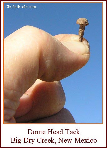
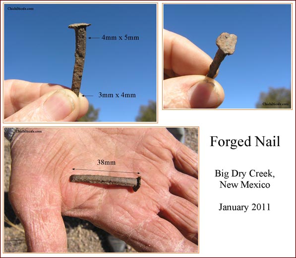
On the northeast cutbank thirty feet from the aglet, at the head of a subtle, almost imperceptible, rainwater drainage most obvious as a reptile trail, we found a forged, wrought dome-head tack. These tacks were available in the sixteenth-century, so the piece could be a product of the Coronado Expedition. Although such tacks persisted into the nineteenth-century, a date of arrival for this particular tack at Big Dry Creek subsequent to the sixteenth-century is not likely. The 1700s Spanish soldiers were probably less inclined to carry tacks than had been the domestic Coronado expeditionaries who preceded them by some 200 years. Mountain Men or scalp hunters from the first half of the 1800s were also unlikely to carry these tacks. Apaches were not likely to collect tacks on their raids. By the middle 1800s, wrought nails had become uncommon in America. At the time the first homesteaders and Federal soldiers arrived at Big Dry Creek, nails cut by machine from sheet metal dominated the American market and did so until the late 1880s when round wire nails began to account for almost all nail production. We concluded that the dome-head tack is more likely than not a residual of the Coronado Expedition.(30)
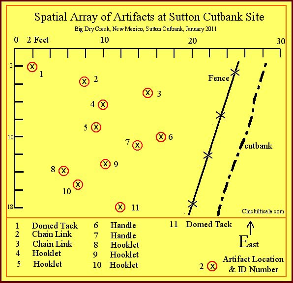
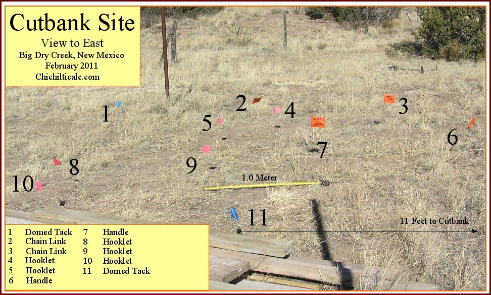
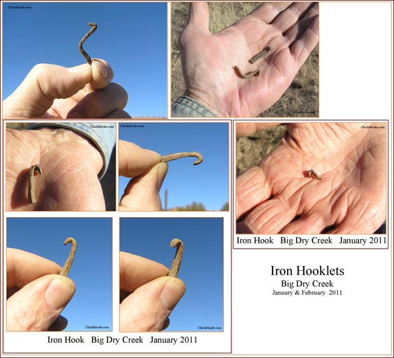
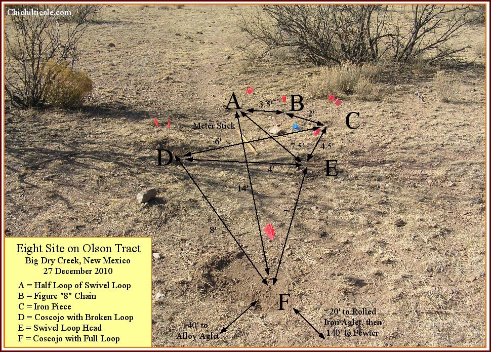
On the topographic bench on the Sutton property about 800 feet west of the aglet and dome-head tack we found an area measuring 18' x 16' immediately beside the cutbank that contained a cluster of iron artifacts. Two of these pieces were forged iron, dome-head tacks identical to the one found near the aglet. Also within the cluster were two small forged iron handles, two forged iron chain links, and five forged iron elongate “hooklets” of similar form, function and craftsmanship. Two hundred eighty feet west we found another elongate hooklet like those within the cluster. Seventy feet northeast of the cluster we discovered a forged iron nail.
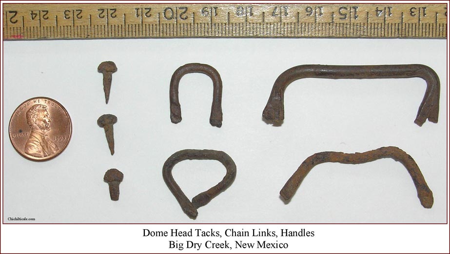
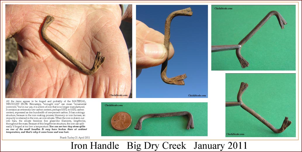
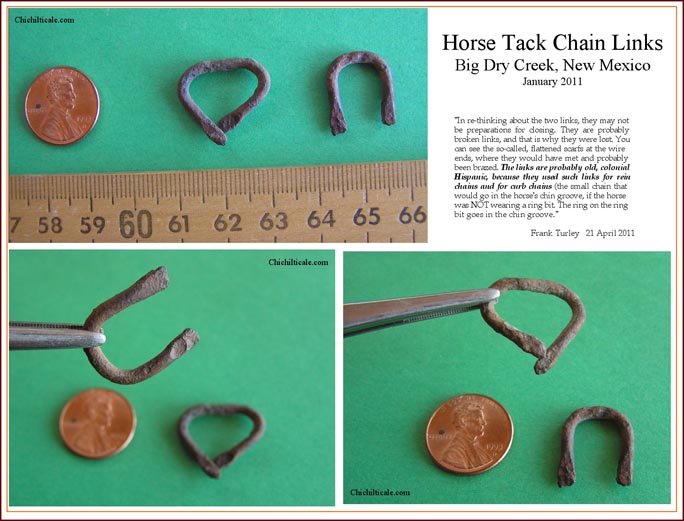

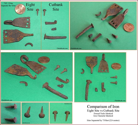
Professional blacksmith, Spanish colonial horse tack authority and author Frank Turley of Santa Fe examined the iron pieces and reported that “all the items appear to be forged” from bloomery iron, which fell into disuse by the time of the American Civil War. About the chain links, handles, forged nail, and hooklets Turley wrote:
"[At first glance] these [chain links] appear to be preparation for a link. When small links are made, they are flattened on the ends (scarfed) and closed together. They can be brazed with brass or copper. In re-thinking about the two links, they may not be preparations for closing. They are probably broken links. You can see the so-called, flattened scarfs of the wire ends, where they would have met and probably been brazed. The links are probably old, colonial Hispanic, because they used such links for rein chains and for curb chains (the small chain that would go in the horse's chin groove, if the horse was not wearing a ring bit.) These could be handles, but for something small. You can see two tiny stress splits on one of the small handles. It may have broken there at ambient temperature. [The forged nail] could have been used for a number of things... It is easier to forge a square nail than a round one, and it is stronger. [The hooklets] look like horseshoe nail shanks with the clinches, the bent end portions, still showing. I cannot account for the fact that the nail heads are missing, if that is the case. The reasons for these pieces are unknown to me.”(31)
We consider the dome-head tacks alone to be strong evidence of Coronado. Because of the presence of these tacks within the cluster, it is not prudent to eliminate the chain links, handles and elongate hooklets as being Coronado artifacts also. Just as significant, the large forged wrought nail recovered near the cluster was the only one of its type found on the Minnie Bell site, and an almost identical nail was recovered at Piedras Marcadas. The totality of these circumstances supports a Coronado source for the pieces.
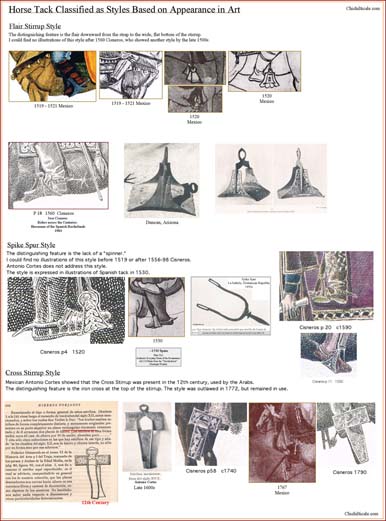
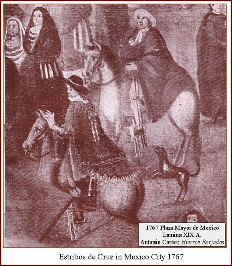
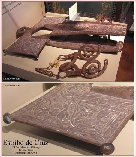
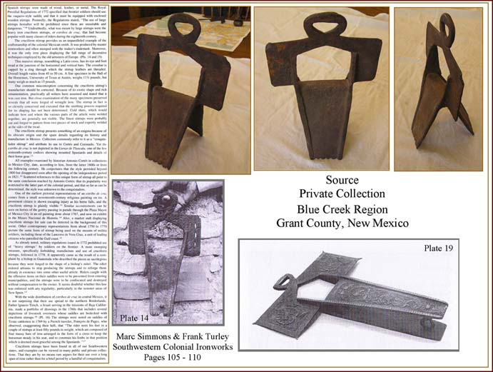
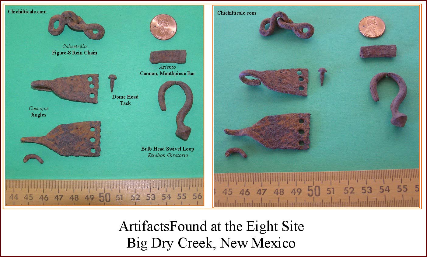
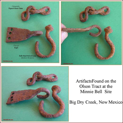
Within a 14’ by 7’ cluster on the topographic bench 160 feet west of the pewter medallion, forty feet northwest of the copper alloy aglet and nineteen feet west of the dome-head tack, the team found five pieces of confidently identified iron horse tack and a single tentatively identified piece of tack. Twenty-seven feet down slope we found another piece of horse tack. All seven pieces lay in the same subtle drainage as had the dome-head tack found on the Olson tract. Included in the horse tack were two coscojos (jingles). One was intact, and the other was almost complete, as just the tip of the loop was broken off, which was recovered 27’ away. Also included in the artifact cluster was a bulb-head swivel loop from an eslabon giratorio. The loop was broken where most wear had occurred, and the head piece was found separated from the distal end of the loop by about seven feet. Two connected links of a figure-eight cabestrillo (rein chain) were found. A solid bar one inch long and 0.15" thick was found two feet from the chain; this piece has been tentatively identified as part of an asiento (mouthpiece bar).(32)
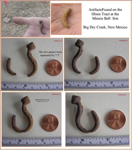
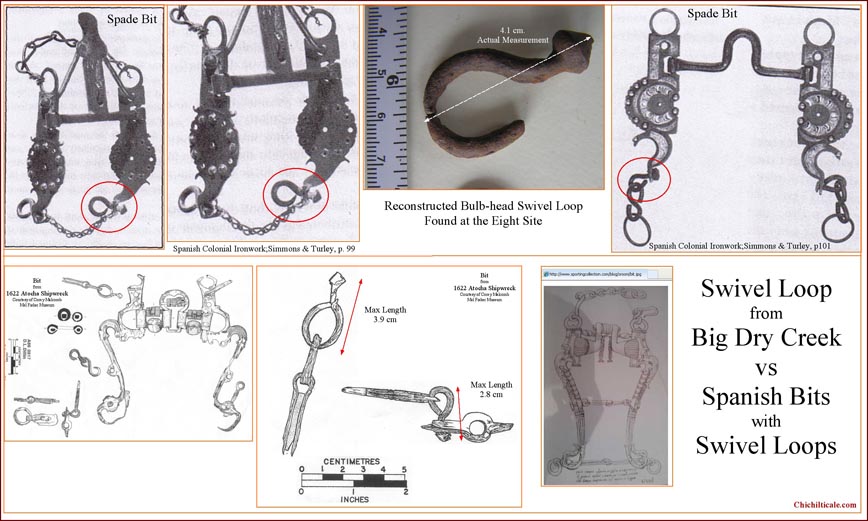
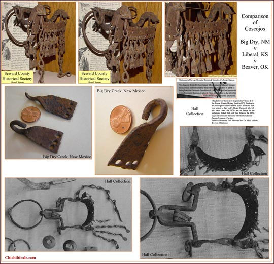
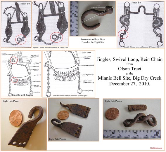
Our effort to assign a date to the horse tack included using data from the public domain to construct a database of artists, dates of their work, and copies of their paintings, sketches, etchings or sculptures of horse tack. Our database focused on the time span from AD 1400 to the twentieth-century. We added to this database by consulting with and visiting museums and private collectors. We obtained photographs from some museums, and we recorded our own images in other museums. We made direct, side-by-side comparisons of Big Dry Creek horse tack with pieces in these collections. We observed that the type of jingle, bulb-head swivel loop, rein chain, and mouthpiece bar recovered at the Minnie Bell site is on many pieces of horse tack found throughout the Southwest, California and Great Plains. The geographical expanse and the quantity of this type of horse tack suggest an association with a group more numerous and of longer duration than represented by the Coronado Expedition.
The team concluded that the pieces of iron tack were bearer-associated, and that the jingles offered the best temporal measurement of the complete tack assemblage. Coscojos are present in the collection at Presidio La Bahia, Goliad, Texas, but I remain uncertain that they date before 1749. Four score of jingles were recovered from the 1757-1770s San Sabá mission site at Menard, Texas, suggesting that they were in common usage by that time. Wandering French naval officer Pierre Marie Francois de Pages described jingles of 1767 as “trinkets of steel which, like as many little bells, are kept perpetually ringing by the motion of [the] horse.” Artist José Cisneros sketches jingles on a south Texas ranchero c. 1815. The New Mexico Spanish Colonial Arts Collection includes a nineteenth-century New Mexican ring bit with jingles. Our interpretation of the temporal range of jingles begins with their becoming stylish by c. 1750, and remaining so for about a century. This suggests that the tack could have arrived at the Minnie Bell site with Spaniards Menchero, Vildósola-Bustamante, Echeagaray or Zúńiga in 1747, 1756, 1788 or 1795. However, being as the Apaches were plundering well before 1747 and did so into the 1880s, the tack could also have arrived with those raiders.(33)
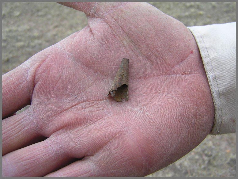
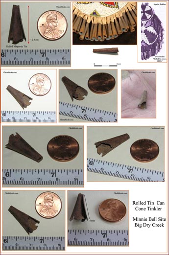
Adding to what must be considered when dating the horse tack is a conical rolled tin tinkler found twenty feet northeast of the assemblage. The tinkler is almost certainly of Apache manufacture and origin. Tin cans were first manufactured about 1810; this is likewise the date of the first patent of these items in England. The first American patent was granted in 1818. These first tin cans were hazardous if used for cooking in the can itself. By the middle of the nineteenth-century, however, the technology improved so that tin cans became omnipresent. Anthropologist John Cameron Greenleaf, now deceased, examined tin cans from the Johnny Ward Ranch, located next to Sonoita Creek west of Patagonia, in Santa Cruz county, Arizona. Ethnohistorian Bernard L. Fontana, lead author of the monograph containing Greenleaf’s work, suggested, “While it's theoretically possible Apache tin tinklers could date from the early 19th century, my guess is that they are more likely to date post 1850, by which time tin cans were becoming ubiquitous in the American West.” Whether or not the iron horse tack and the rolled tin tinkler are bearer-associated remains unknown. If they are bearer-related, then the iron tack is almost certainly of Apache origin because the tinkler dates no earlier than 1820, by which time the Spaniards had departed, and no later than 1886, by which time the Apaches had left the region.(34)
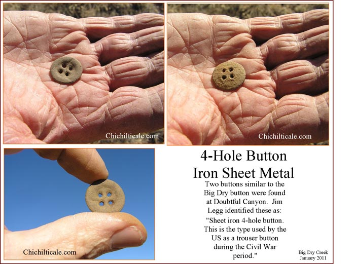
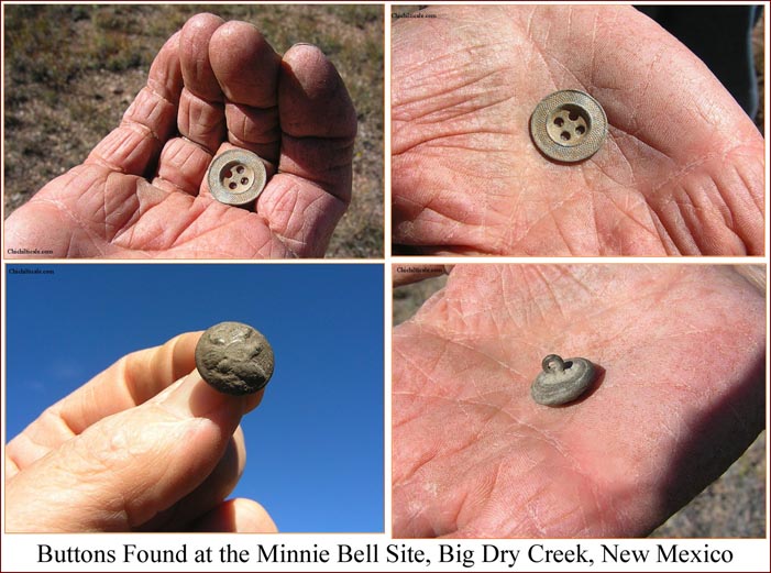
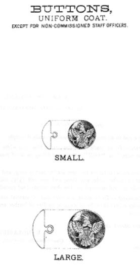
The team found three buttons on the western end of the topographic bench on the Sutton tract. One of these was a USM 1854 enlisted man’s button, the classic Federal button of the Civil War and into the 1870’s. Another was a sheet iron four-hole button used as a Federal military trouser button. These two buttons were most likely left at the site by the intermittent Federal military presence there from the 1870s into the late 1880s, but could also have come from a homesteader or traveler who wore military buttons. Another piece was an adorned, non-magnetic alloy, four-hole, self shank button that we have concluded was a civilian button from the homesteader era.(35)
Also found on the Sutton western topographic bench was a heavy brass grommet unlike contemporary grommets. We interpret that this piece was part of a tent or tarp. It could have arrived at the site with the Federal military, or the homesteaders, or with members of the Civilian Conservation Corps of the 1930s – 1940s who performed soil conservation work in the immediate area and lived in tents.
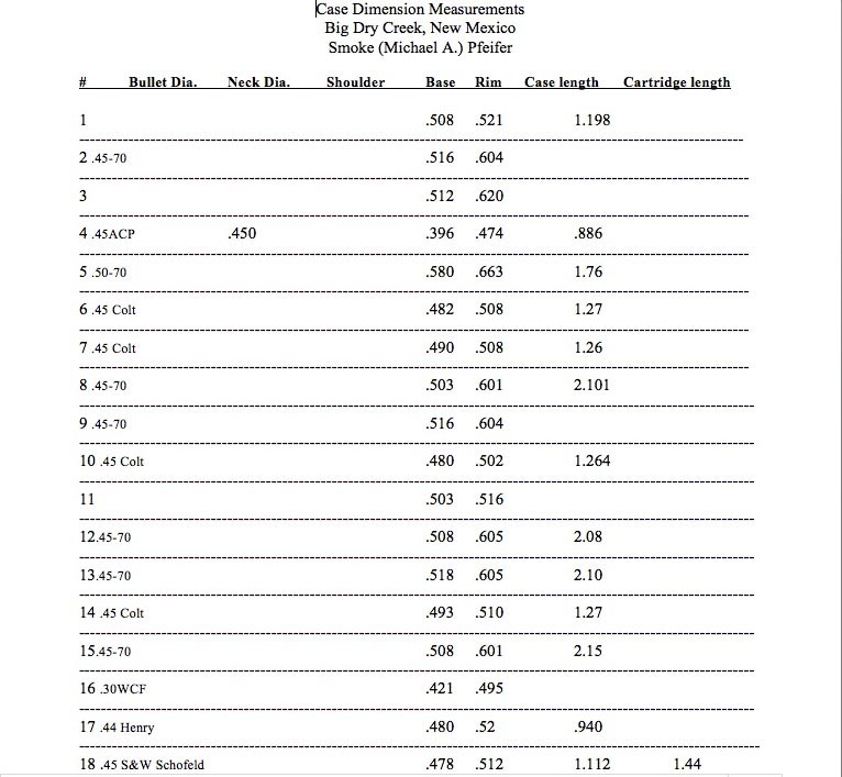
Numerous cartridge casings were found, including shotgun shells, 0.22 shells, and modern hunting shells. Of most interest to us were cartridges that could date from the nineteenth-century. We sent seventeen shell casings and one corroded unspent shell to ammunition expert Michael A. Pfeiffer of Russellville, Arkansas. Of the fifteen cartridges identified, the years of first manufacture of eleven casings dated 1860 to 1875 inclusive, and three dated 1887 to 1894 inclusive. We interpret these fifteen casings as being associated with the nineteenth-century Federal military presence and the earliest rancher Siggins and his cowboys.(36)

At the Minnie Bell site, Big Dry Creek serves as a township line, a county line and a property line. Tom and "Red" Humphreyville own private land on the south side of Big Dry, and they kindly granted us permission to explore there. Our preparatory field reconnaissance there had indicated Meader Hill to be a viable prospect. During May 2011 the team conducted a grid search of the Humphreyville property on this hilltop using a Blennert Sled and "swinging sticks." We found the surface essentially sterile of metal detector targets.(37)
Our reconnaissance had also shown us that the Humphreyville property contains a bench above the floodplain that represents the most favorable campsites for the 1540 Coronado Expedition. Unfortunately, this bench does not lend itself well to metal detecting exploration because the surface is rife with metal from the homesteader era of Lee, Meader, Snider and Hines. These adverse metal conditions forced us to avoid the bench and to focus our search on the slopes of the southern riser (low cutbank) and the wash from the bench through the riser, where in May 2011 we found one artifact of interest – an asidero (headstall ring on horse tack). Since we could find no evidence of the style prior to the middle 1700s, we consider the most likely bearer to have been a Spaniard of 1747, 1756, 1788, or 1795.(38)
West of the Sutton property on the north side of Big Dry Creek was land owned in 2010 by Hayden Forward. During the pilot metal detector survey on that land in June of that year, we found an iron awl buried directly beside a Mimbres black-on-white potsherd. We cannot assign an age to the awl.
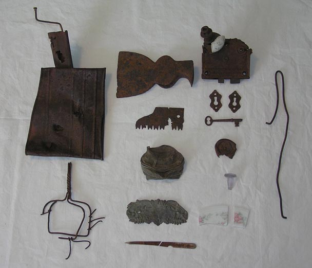
We observed copious quantities of homesteader material during our search of the Minnie Bell site, and these pieces were especially interesting to the namesake of the location. Minnie Bell studied, identified, and categorized the artifacts and provided a handwritten report to the author. Included in the collection were a flour sifter, potato masher, tin bowls, spoons, perforated spice jar top, jar lid locks, chicken grabber, stove parts, buckets, handles, key, door locks, hinges, ceramic door knob, broken glassware of dishes, lids, jars and bottles, pieces of iron pot-bellied kettles, lettered tin cans, bottle tops, buttons, pins, rivets, clock parts, lamp wick, metal rifle butt, buckles, chains, swivels, wagon parts, rubber tire scraper, screws, nuts, bolts, nails and tacks, chicken wire, hooks, springs, bedsteads, shaping hammer, axe, saw blades, horse tack, used flared horseshoes, boot heels, lipstick, nail file, and a harmonica.
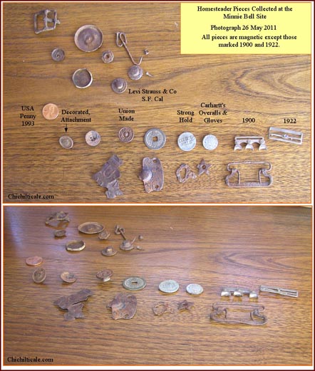
These objects contributed to identification of post-Civil War artifacts by demonstrating what these early settlers possessed, thereby aiding us in judging what was NOT homesteader material. For example, flat-head homesteader tacks were distinct from dome-head tacks by their size, shape, and craftsmanship; cut nails and wire nails used by the homesteaders were common while forged nails were almost singular; homesteader chain was distinct from forged horse tack rein chain; homesteader wire handles were larger and unlike the forged, flared handles found in the cluster with the chain links and dome-head tacks. These comparisons elevate my confidence in our identification of Big Dry Creek artifacts.(39)
The Minnie Bell site artifacts that we assigned to the Coronado Expedition match well categorically with proposed Coronado pieces in the collections from Kuykendall Ruins, Doubtful Canyon, Hawikku, Kyakima, Santiago Pueblo, Piedras Marcadas, LA 54147 and Jimmy Owens.
Minnie Bell Henry Hudson facilitated the exploration at Big Dry Creek. She also introduced me to collectors and ranchers that contributed to this report and to the Coronado exploration program in its totality. Minnie Bell leaves a firm footprint on our understanding of the Coronado Trail.
Richard Flint, Shirley Cushing Flint, Carroll L. Riley, and Brent Locke Riley have contributed to and supported this exploration from its beginning in 2004. Cal said more than once, “We need to get him into the San Francisco Valley.” Our discovery at the Minnie Bell site suggests that we have.
Loro Lorentzen has contributed careful thought, analysis, and sweat labor to our exploration and is part of all the discoveries. Although not present at the Minnie Bell site, Dan Kaspar, John Blennert, and Gordon Fraser helped prepare us for our exploration at Big Dry Creek.
Editor Durwood Ball and the staff of the New Mexico Historical Review have been instrumental in publishing the reports of our exploration. I am especially grateful to Donna Schank Peterson, whose wordsmithing and organizational skills have made my reports the strongest they could be.
Without the cooperation of the landowners at Big Dry Creek, our exploration could not have happened. My warmest gratitude to them for “letting me on” their property. Jerry Jump and Kenny Sutton were especially accommodating.
Artifact identification continued as a group effort. Frank Turley contributed to and influenced mightily our conclusions about the iron and the iron artifacts found at Big Dry Creek. Matthew Schmader generously made available for examination and comparison the collection of artifacts recovered at Piedras Marcadas. Franco Marcantonio, geochemist at the Radiogenic Isotope Geochemistry Laboratory in the Department of Geology and Geophysics at Texas A&M University, and Nelia Dunbar, geochemist and manager of Electron Microprobe Lab, New Mexico Bureau of Geology and Mineral Resources, Earth and Environmental Science Department, New Mexico Tech, provided technical expertise to the program. Smoke Pfeiffer contributed respected analysis and identification of cartridges found at the Minnie Bell site. I am grateful to John H. Madsen for sharing his Spanish colonial database, and for his longstanding contribution to Southwestern history. Nancy Marble of the Floyd County Historical Museum has supported and contributed to our exploration program from the beginning. On a broader scale, I recognize that the collectors, ranchers, professors and curators who have provided me access to their artifacts have played a paramount role in this exploration. They facilitated comparison of our pieces to those in their collections, thereby providing “look-alikes” that suggested comparable temporal artifacts, lending confidence to our conclusions about the presence or absence of the Coronado expedition. To all of them I send my warmest gratitude.
The Glenwood Community Library, especially Judy Truett, obtained through the inter-library loan system many of the books and documents referenced and consulted for this report. Adding to this support were Ken Dayer at the Silver City Library, Tom Hester at Historical Research in the Silver City Museum. Ann Massmann and Nancy Brown-Martinez at the Center for Southwest Research kindly provided the Spanish documents pertaining to the Menchero and Celís adventures. John Kessell kindly shared information on where to find specific source documents.
For their counsel on various issues, I thank Bernard L. “Bunny” Fontana, Sarah Herr, Nancy Kenmotsu, Alan Ferg, Samuel Truett, and Karl Laumbach.
At the time this report was typeset in March 2013 we had no Coronado exploration in progress. Considering that this might be my final report, and that I might not get another chance in print, I want to remind Karen Whiteside Brasher how much she contributed to this adventure and to tell her again how much I love her.
(1) For various and conflicting accounts of the ambush at Soldier’s Hill and the death of surgeon Thomas John Claggett Maddox, see: William French, Some Recollections of a Western Ranchman, New Mexico 1883-1899; Argosy-Antiquarian,Ltd. (New York, 1965) 2 vol., p 111-15,v.1; William H. Mullane, Apache Raids: News about Indian activity in the Southwest as reported in The Silver City Enterprise November 1882 through August 1886; copyright 1968; The Southwest Sentinel, 22 December 1885 in “Soldier’s Hill,” information compiled by Terry Humble, p. 1, Silver City Public Library, Southwest History Drawer, Soldier’s Hill; James P. Finley, “Fort Huachuca and the Geronimo Campaign 1886,” in Huachuca Illustrated: A Magazine of the Fort Huachuca Museum; Volume 7, 1999, p. 55-56; James H. Cook, Fifty years on the Old Frontier, As Cowboy, Hunter, Guide, Scout, and Ranchman; Yale University Press (New Haven, 1923) 182; Jerry Eagan, “Studying the Ground: Searching for Soldier’s Hill, site of a renowned Apache ambush in 1885” in Desert Exposure, February 2007; H. W. Daly. “The Geronimo Campaign,” Journal of U. S. Cavalry Association, vol. 19 (1908), 247-262. Some reports describe Maddox as “dismounting” after being shot, and speaking to Babcock or Lieutenant Cabell before suffering the fatal bullet. Military historian Jerry Eagan, however, reported that Maddox took a bullet in the chest and “came off his horse,” and that hospital steward Babcock and Private Beatty then attempted to get Maddox to cover, but the surgeon was shot in the back of his head. As for the reporters of the time, Fountain was not at the death site, and McKinney, who was present, did not report on the death, so no witness who was actually at Maddox’s demise reported on that event. French’s account is as he later penned it per his recollection of the ambush as told him by Fountain that night. Fountain’s version of the death of Maddox likely comes from Babcock and Beatty. Fountain reported that all shots fired by the Apaches were within forty yards of the troops, suggesting that Maddox was shot at close range. Fountain described the tierra doblada landscape as “timber and rough land,” and French pointed out that “owing to the nature of the country and the steepness of the hills, it was necessary to travel several miles [to cover] less than half a mile.” French considered tierra doblada “impracticable for horses.” The Apaches withdrew by foot to the west toward the Río San Francisco.)
(2) I previously reported this exploration: “The current exploration model… route was predicted in January 2005 and remains in effect after two apparent affirmations [at Kuykendall Ruins and Doubtful Canyon] of the exploration model. Our current exploration proceeds along this trace.” As will be discussed in this report, a total of four affirmations of the exploration model, an increase of two, are now proposed. Nugent Brasher, “Francisco Vázquez de Coronado at Doubtful Canyon and on the Trail North: The 2011 Report Including Lead Isotopes, Artifact Interpretation, and Camp Description,” New Mexico Historical Review 86 (summer 2011): 347.)
(3) Juan Jaramillo, “Juan Jaramillo’s Narrative,” in Documents of the Coronado Expedition, 1539-1542: "They Were Not Familiar with His Majesty, nor Did They Wish to be His Subjects," ed., and trans., Richard Flint and Shirley Cushing Flint (Dallas: Southern Methodist University Press, 2005): 520; Nugent Brasher, “The Coronado Exploration Program: A Narrative of the Search for the Captain General,” in The Latest Word from 1540: People, Places, and Portrayals of the Coronado Expedition, ed. Richard Flint and Shirley Cushing Flint (Albuquerque: University of New Mexico Press, 2011), 243.)
(4) I have previously reported this route. See: Nugent Brasher, “The Coronado Exploration Program: A Narrative of the Search for the Captain General,” in The Latest Word from 1540: People, Places, and Portrayals of the Coronado Expedition, ed. Richard Flint and Shirley Cushing Flint (Albuquerque: University of New Mexico Press, 2011), 243-246; Nugent Brasher, “Francisco Vázquez de Coronado at Doubtful Canyon and on the Trail North: The 2011 Report Including Lead Isotopes, Artifact Interpretation, and Camp Description,” New Mexico Historical Review 86 (summer 2011): 342 Map 2, 347, 369 n.30. The deeply incised landscape of tierra doblada results from the erosion of coarse, friable Quaternary volcanic sediments existing as pediment gravels, colluvium, valley alluvium, and terrace gravels. The easily eroded terrain exists as a wedge between the steep western walls of the Río San Francisco on the west and, on the east, the Bursam Caldera of the northwestern side of the Gila Wilderness in the Mogollon Mountains. Cedar Breaks topography extends from Little Dry Creek on the south to the Río San Francisco on the north. Cedar trees, considered to be intrusive and uncommon in 1540, dominate the vegetation within the Breaks. For a discussion of this geology, see: James C. Ratté and David L. Gaskill, Reconnaissance Geologic Map of the Gila Wilderness Study Area, Southwestern New Mexico, Map I-886; U. S. Geological Survey, Reston, Va., 1975.)
(5) Nugent Brasher, “The Chichilticale Camp of Francisco Vázquez de Coronado: The Search for the Red House,” New Mexico Historical Review 82 (fall 2007): 433–68; "The Red House Camp and the Captain General: The 2009 Report on the Coronado Expedition Campsite of Chichilticale," New Mexico Historical Review 84 (winter 2009): 1-64; "Spanish Lead Shot of the Coronado Expedition: A Progress Report on Isotope Analysis of Lead from Five Sites," New Mexico Historical Review 85 (winter 2010): 79-81; “Francisco Vázquez de Coronado at Doubtful Canyon and on the Trail North: The 2011 Report Including Lead Isotopes, Artifact Interpretation, and Camp Description,” New Mexico Historical Review 86 (summer 2011):325-75; “The Coronado Exploration Program: A Narrative of the Search for the Captain General,” in The Latest Word from 1540: People, Places, and Portrayals of the Coronado Expedition, ed. Richard Flint and Shirley Cushing Flint (Albuquerque: University of New Mexico Press, 2011), 229-61. I reported this discovery at Big Dry Creek in Brasher, “Francisco Vázquez de Coronado at Doubtful Canyon,” 2011, 369 n. 30. Regrettably, the legend of Map 3 of my 2011 report contains an error: the trail symbol for the Coronado Trail is incorrect; readers should know that the Coronado Trail passed through Tarasca.)
(6) Minnie Bell Hudson, Home on the Range: Her Story & Recipe Roundup (Payson, AZ: Git A Rope! Publishing, Inc, 2006. For a comment by Minnie Bell concerning where the Coronado Expedition could have climbed onto the Mogollon Rim, see: Nugent Brasher, “The Coronado Exploration Program: A Narrative of the Search for the Captain General,” in The Latest Word from 1540: People, Places, and Portrayals of the Coronado Expedition, ed. Richard Flint and Shirley Cushing Flint (Albuquerque: University of New Mexico Press, 2011), 235.)
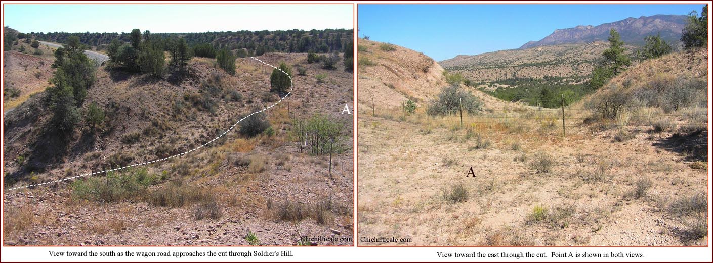
(7) Minnie Bell, Karen Brasher and I set out to trace the old wagon road. We started at Soldier’s Hill. Minnie Bell knew the road was there because her neighbor Jess Hines, who had helped build the unpaved vehicle road during the 1920s, knew the site. He had found cartridges from the Soldier's Hill ambush, and he had taken Minnie Bell, who was then only a little girl, to the spot to show and tell the local history. The wagon road descended from Soldier’s Hill through a natural cut to drop into a basin of eroded topography. The old road followed the path of least resistance for wheels, and the route was sometimes outlined with rocks on each side, appearing like particular portions of the Butterfield Trail in Doubtful Canyon. Off the trace was “up-and-down” tierra doblada, terrain to be avoided by herds of Coronado livestock. The contemporary game trail followed the wagon road. Subtle signs, such as gentle cuts, shallow ruts, unexpected level spots, and broken lines of rocks revealed the old road. Along the road itself was "trail trash" – parts of wagons, carriage bolts, horseshoes, decayed tin, broken crockery. These surprises seemed to be "out in the middle of nowhere" unless one recognized an old road. The wagon road we traced fits the description of the road location offered by late nineteenth-century rancher and historian William French, who had traveled the wagon road often. See: William French, Some Recollections of a Western Ranchman, New Mexico 1883-1899; Argosy-Antiquarian,Ltd. (New York, 1965) 2 vol., 112-19,v.1. The wagon road is shown on: United States Geological Survey, Mogollon, New Mexico Quadrangle, 1912. The actual Soldier’s Hill ambush site was been erased by the major landscape alteration of the modern highway.)
(8) Our dataset of prehistoric sites, extracted from the Archaeological Records Management Section (ARMS) Database in 2004, shows five individual masonry sites in the Slash SI prospect. Our own exploration has discovered eight prehistoric sites. For a description of our ARMS dataset, see: Nugent Brasher, “The Coronado Exploration Program: A Narrative of the Search for the Captain General,” in The Latest Word from 1540: People, Places, and Portrayals of the Coronado Expedition, ed. Richard Flint and Shirley Cushing Flint (Albuquerque: University of New Mexico Press, 2011), 239 Map 9.2, 258 Note 33. For locations of the eight prehistoric sites we have discovered on the Slash SI Prospect see Map 2. )
(9) Nugent Brasher, “The Coronado Exploration Program: A Narrative of the Search for the Captain General,” in The Latest Word from 1540: People, Places, and Portrayals of the Coronado Expedition, ed. Richard Flint and Shirley Cushing Flint (Albuquerque: University of New Mexico Press, 2011), 239 map 9.2; Despoblado is best described as unsettled land in preference to uninhabited land. A despoblado does not require the vacancy of humans, rather the vacancy of long-term settlements. Historian and Coronado authority Richard Flint wrote, “Consistently, early modern Spanish usage of "despoblado" is for reference to areas lacking sedentary populations (although there may have been nomadic or semi-nomadic populations in those very same territories). Despoblado is unsettled land without evidence of permanent human presence." Email to author 5 Jan 2012 from Richard Flint.)
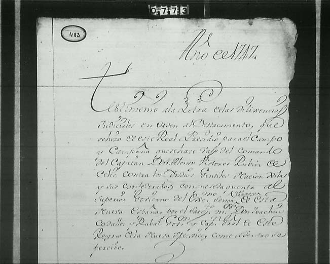
(10) Don Juan Bautista de Anza, Governor of New Mexico, referred to this adventure as the “Great Campaign” in a 1 November 1779 letter to Commander-General El Cavallero de Croix, as did Croix’s assessor Pedro Galindo Navarro in a letter dated 28 July 1780 to Croix. Both letters mistakenly claimed the adventure occurred in 1749 rather than 1747. (Alfred Barnaby Thomas, Forgotten Frontiers: A Study of the Spanish Indian Policy of Don Juan Bautista de Anza, Governor of New Mexico 1777-1787 (Norman: University of Oklahoma Press, 1932): 173, 181.) For the original statement concerning the Celís adventure, see: Report of Alonso Victores Rubí de Celís of an Expedition Against the Gila Apaches, December 6-26, 1747, document 483, Center for Southwest Research, Albuquerque. Bishop Dr. Pedro Tamarón y Romeral reported on the campaign; for that account see Eleanor D. Adams, “Bishop Tamaron’s Visitation of New Mexico, 1760,” Historical Society of New Mexico, Vol. XV, February 1954, p. 89. For an overview of the campaign, see: John L. Kessell, “Campaigning on the Upper Gila,” New Mexico Historical Review XLVI, No. 2 (April 1971): 135-39; Marc Simmons, “Attempts to Open a New Mexico-Sonora Road,” Arizona and The West, V. 17, No. 1 (Spring 1975) p 9-10, map. The Saliz Mountains lie on the western side of the Río San Francisco between Spurgeon Mesa and Reserve. Federal highway 180 ascends the western side of these mountains and crosses the highest road elevation at Saliz Pass. The Great Campaign passed through this immediate area. The local pronunciation of Saliz is essentially the same as the Spanish pronunciation of Celís, suggesting the origin of the place name.)
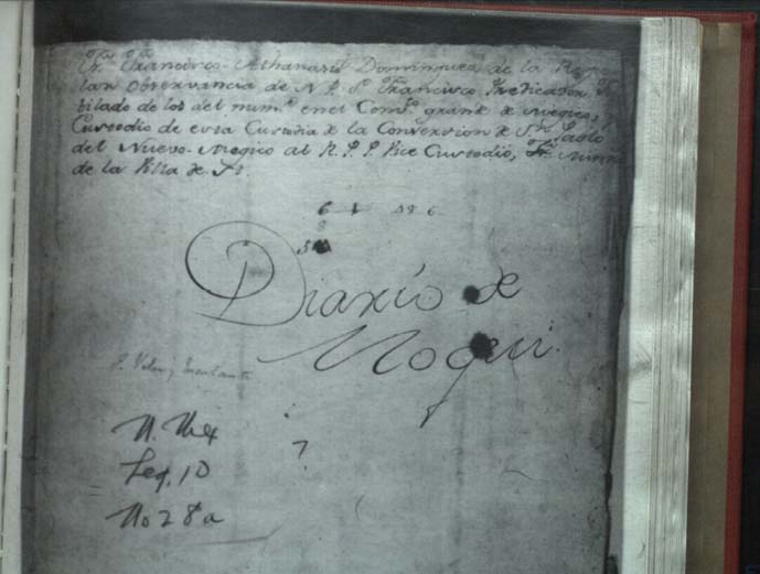
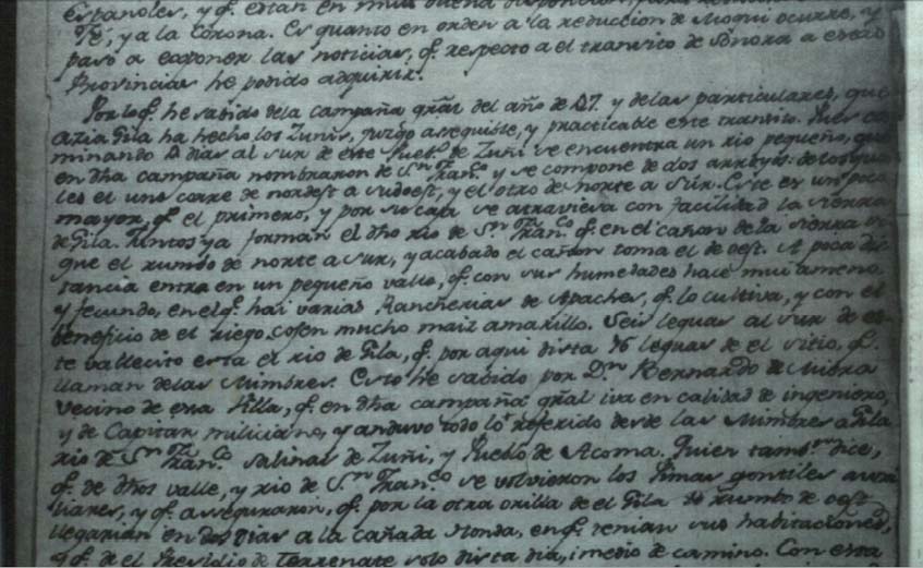
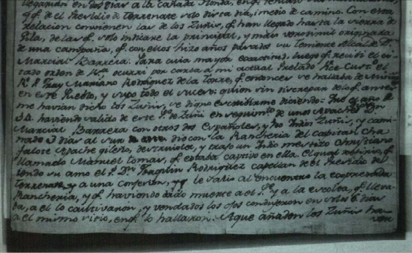
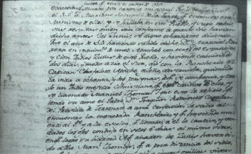
(11) Translation by Richard Flint. Original source Biblioteca Nacional, Mexico, Archivo Franciscano, leg. 10, nos. 28a and 61, copy from Center for Southwest Research, Albuquerque. Readers can find a previous translation of the Escalante letter in Alfred Barnaby Thomas, Forgotten Frontiers: A Study of the Spanish Indian Policy of Don Juan Bautista de Anza, Governor of New Mexico 1777-1787 (Norman: University of Oklahoma Press, 1932): 155-56. Additional comments pertaining to the 1747 expedition, mistakenly identified as 1749, are on pages 173 and 181 of that volume. Also in his 1775 letter, Escalante mentioned a 1754 military excursion south of Zuni, but I interpret that this party did not reach Big Dry Creek. Support for the claim that the Río San Francisco was named during the Great Campaign of 1747 comes from examination of maps provided by archaeologist Peter L. Eidenbach. His map presentation shows that prior to Miera’s 1758 map, the Río San Francisco remained unnamed; in 1758, after the Campaign, Miera shows the named river. Peter L. Eidenbach, An Atlas of Historic New Mexico Maps, 1550-1941 (University of New Mexico Press: Albuquerque, 2012) 40.)
(12) I consider the Río Tularosa to be Coronado’s Río Frío. Coronado’s famous crossing of the Río Balsas occurred at the Río San Francisco at Alma, where that river is not contained within box canyons. For a discussion of that crossing, see: Nugent Brasher, “The Coronado Exploration Program: A Narrative of the Search for the Captain General,” in The Latest Word from 1540: People, Places, and Portrayals of the Coronado Expedition, ed. Richard Flint and Shirley Cushing Flint (Albuquerque: University of New Mexico Press, 2011), 245-47. I am grateful to Anza trail historian Joe Myers, who directed my attention in February 2012 to Escalante’s letter after recognizing the Río Tularosa in the description. John Kessell, as well as historian Marc Simmons, each presented maps showing their interpretation of the campaign’s route, which included passing by Big Dry Creek. (John L. Kessell, “Campaigning on the Upper Gila,” New Mexico Historical Review XLVI, No. 2 (April 1971): map 141; Marc Simmons, “Attempts to Open a New Mexico-Sonora Road,” Arizona and The West, V. 17, No. 1 (Spring 1975) p 9-10, map.)
(13) John L. Kessell, “Campaigning on the Upper Gila,” New Mexico Historical Review XLVI, No. 2 (April 1971): 146-47)
(14) Nugent Brasher, "The Red House Camp and the Captain General: The 2009 Report on the Coronado Expedition Campsite of Chichilticale," New Mexico Historical Review 84 (winter 2009): 44-5; “Francisco Vázquez de Coronado at Doubtful Canyon and on the Trail North: The 2011 Report Including Lead Isotopes, Artifact Interpretation, and Camp Description,” New Mexico Historical Review 86 (summer 2011):355-56; José de Zúńiga, “Una expedición militar de Tucson (Arizona) a Zuńi (Nuevo México),” in La Espańa ilustrada en el Lejano Oeste: viajes y exploraciónes por las provincias y territorios hispánicos de Norteamérica en el siglo XVIII, ed. Amando Represa, Estudios de historia (Valladolid, Spain: Junta de Castilla y León, Consejería de Cultura y Bienstar Social, 1990), 89–100. Represa incorrectly reports the year of the expedition as 1791; the actual year was 1795. The count of 280 leatherjackets and 120 presidio men is from George P. Hammond, "The Zúńiga Journal, Tucson to Santa Fé: The Opening of a Spanish trade Route, 1788-1795," New Mexico Historical Review 6, 1 (1931): 40-65. Richard Flint pointed out that since presidial soldiers of that era all tended to wear cueras de anta, the distinction between leatherjacket and soldier is unexpected. With respect to the number in the Zúńiga party, Represo reports 151 soldiers and Apaches, while Hammond writes 140 soldiers and eight Apache scouts.)
(15) For the purpose of this report, unless indicated otherwise, I use “Apache” as an inclusive term for all the individual groups combined together. Trappers included James Ohio Pattie. I interpret the trace of his trapping trail to place him at the junction of the Río Gila and the Río San Francisco on 1 January 1825. He claims to have traveled upstream on the Río San Francisco, reaching its head by 14 January. Experienced Río San Francisco river rafter Loro Lorentzen describes the January river as ice cold, suggesting that Pattie stayed away from river narrows. From Pleasanton, New Mexico to Clifton, Arizona, the river passes through a box canyon. To avoid these narrows, Pattie most likely departed the river and skirted its southern and eastern sides, a course that would have sent him directly toward and through the Minnie Bell site. Pattie offers evidence for such: "… the cliffs in many places so near the water's edge, that we were compelled to cross points of the mountain…" James Ohio Pattie; "The Personal Narrative of James O. Pattie: The True Wild West of New Mexico and California" The Narrative Press, Santa Barbara, CA, 2001, p76-77. Some trappers turned their attention to scalp hunting, thereby beginning the War of Apache Scalps. Beginning in 1838 and extending into 1848, the notorious scalp hunter James Kirker and his gang roamed east and west of the Río Grande hunting Apaches. Although I could find no record that Kirker or other scalp hunters had specifically visited Big Dry Creek, the possibility of their presence there cannot be dismissed. Historian Ralph Adam Smith presents a map of Apache plunder trails that demonstrates Big Dry Creek as along those routes; scalp hunters may have followed these same trails in pursuit of their prey. Evidence of Kirker's hunters in the region in 1848 is that fellow Apaches warned their war chieftain Mangas Coloradas that Americans with Shawnee and Delaware Indians had come to Apachería seeking scalps; Kirker employed these Indians to hunt Apaches. In addition, American traders entered the Mogollon Mountains in 1849 to barter with the Apaches, and these meetings occurred at Mangas Springs, thereby placing Americans within thirty-five miles of Big Dry Creek. The exploits of James Kirker are described in detail in William Cochran McGaw, Savage Scene: The Life and Times of James Kirker, Frontier King; Hastings House Publishers, New York, 1972 and in Ralph Adam Smith, Borderlander: The Life of James Kirker, 1793-1852; University of Oklahoma Press, Norman, 1999. For a map of Apache plunder trails, see: Smith, p. 219; for a verbal description of Apache plunder trails, see: McGaw, p. 87-8, and Donald E. Worcester, The Apaches: Eagles of the Southwest, University of Oklahoma Press, Norman, 1979, p. 41. Edwin R. Sweeney, Mangas Coloradas: Chief of the Chiricahua Apaches, University of Oklahoma Press, Norman, 1998, p. 71-87, 156, 175-77. Per my personal inquiry in an email 11 May 2011, renowned Apache specialist Edwin R. Sweeney reported that Mangas Coloradas used Mangas Springs (Santa Lucia Springs) as his home from 1815 to 1863. Most travelers into the region remained south of Big Dry Creek. The 1846 expedition led by Colonel Stephan Watts Kearny, the emigrants heading to the 1849 California gold rush, and the 1851 survey of United States Land Commissioner John Russell Bartlett all remained well south of Big Dry Creek.)
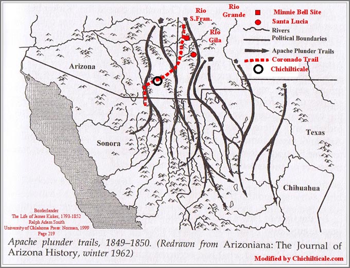
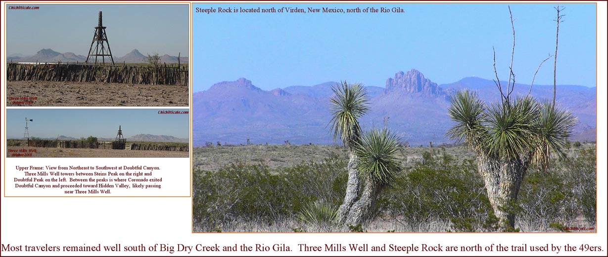
(16) Edwin R. Sweeney, Mangas Coloradas, University of Oklahoma Press, Norman, 1998 p 325-26, 353-54, map p. 6.)
(17) The historical account of the Río San Francisco region provided for the period following the American Civil War is taken from my unpublished 1997 volume, pages 205-226 titled Changes in Lattitude. I provided no citations because I was writing for my pleasure. For sources, I gathered personal accounts, letters, newspaper articles, and memorabilia from local residents, most of them multi-generational. I also consulted books, newspapers and pamphlets, almost all of them from the personal libraries of locals, including Minnie Bell Henry Hudson, June Spurgeon Allred, Marge McKeen, Sharon Linneer, and the Glenwood Community Library.)
(18) This history serves to distinguish the Coronado camp at Big Dry Creek from those at Kuykendall Ruins and Doubtful Canyon in that the Menchero, Vildósola-Bustamante, Echeagaray and Zúńiga expeditions did not occupy those two latter sites. The Menchero Campaign contained 700 metal bearers, some being Indian allies likely bearing metal. The number of metal bearers in the Vildósola-Bustamante detachment remains unknown, but detachments of that time commonly numbered forty to sixty. The Echeagaray party was composed of some 400 metal bearers, and the Zúńiga Expedition included 150 metal bearers. I have reported 400 metal bearers in the Coronado Expedition. I consider that the full contingent of the Menchero Campaign, as well as the entire later detachment, camped once at Big Dry Creek. I consider that Echeagaray and Zúńiga each camped twice at Big Dry Creek, with perhaps the full contingent each time. I consider that the advance party of the Coronado Expedition, consisting of some 100 metal bearers, camped once at Big Dry Creek, as did the following army of 300 metal bearers and the retreating army of 400 metal bearers. These occupations by Spanish metal bearers at Big Dry Creek offered the greatest chance for iron residuals to be deposited at the location until the arrival of Americans following the Civil War, when iron begin to flood the site. While trappers and scalp hunters, each metal bearers, arrived at Big Dry Creek prior to the mid-1850s, it is unlikely that any of these parties numbered in the hundreds. In the same way, it is unlikely that Apaches, considered to be limited metal bearers, ever gathered at Big Dry Creek in numbers equal to the Spanish parties. Based solely upon the number of iron bearers suspected to have visited the site, the greatest probability is that the bearer was a Spaniard or an American. Within these two groups, Spanish and American, there are two categories – soldiers and settlers – by which artifacts can be distinguished. Spanish domestic objects are more likely associated with Coronado than with the Menchero, Vildósola-Bustamante, Echeagaray or Zúńiga military parties. For Coronado metal bearers, see: Nugent Brasher, “Francisco Vázquez de Coronado at Doubtful Canyon and on the Trail North: The 2011 Report Including Lead Isotopes, Artifact Interpretation, and Camp Description,” New Mexico Historical Review 86 (summer 2011): 359. For Menchero metal bearers, see: John L. Kessell, “ Campaigning on the Upper Gila,” New Mexico Historical Review XLVI, No. 2 (April 1971): 136-37. For Echeagaray metal bearers, see: George P. Hammond, "The Zúńiga Journal, Tucson to Santa Fé: The Opening of a Spanish trade Route, 1788-1795," New Mexico Historical Review 6, 1 (1931): 42. For Zúńiga metal bearers, see: George P. Hammond, "The Zúńiga Journal, Tucson to Santa Fé: The Opening of a Spanish trade Route, 1788-1795," New Mexico Historical Review 6, 1 (1931): 49, and José de Zúńiga, “Una expedición militar de Tucson (Arizona) a Zuńi (Nuevo México),” in La Espańa ilustrada en el Lejano Oeste: viajes y exploraciónes por las provincias y territorios hispánicos de Norteamérica en el siglo XVIII, ed. Amando Represa, Estudios de historia (Valladolid, Spain: Junta de Castilla y León, Consejería de Cultura y Bienstar Social, 1990): 91. Note that the tallies of Hammond and Represa are slightly different. For an alternative count of Coronado metal bearers, see: Matt Schmader, “Thundersticks and Coats of Iron: Recent Discoveries at Piedras Marcadas Pueblo, New Mexico,” in The Latest Word from 1540: People, Places, and Portrayals of the Coronado Expedition, ed. Richard Flint and Shirley Cushing Flint (Albuquerque: University of New Mexico Press, 2011): 316.)
(19) Richard Flint, email to author, 23 June 2011, citing AGI, Justicia, 258.)
(20) For a discussion of Apaches and horses, see: Donald E. Worcester, The Apaches: Eagles of the Southwest, University of Oklahoma Press, Norman, 1979, p 5-45, esp. 9, 11, 12, 14, 17, 21, 33-34, 37, 43-44; “The Beginnings of the Apache Menace of the Southwest,” New Mexico Historical Review, Vol. XVI, No. 1, January 1941, p. 1-14, esp. 5; Jack D. Forbes, "Apache Navajo and Spaniard," University of Oklahoma Press, Norman, 1960, p 29-40, 107- 119, esp. 113; "The Appearance of the Mounted Indian in Northern Mexico and the Southwest, to 1680," Southwestern Journal of Anthropology, Vol.XV, No. 2, 1959, p189-212, esp. 196, 201, 202. Forbes and Worcester offer differing interpretations of when Apaches first learned to ride, as well as when the Spaniards hired Native Americans as shepherds. See Forbes p. 110 and Worcester p. 10-11. Richard Flint commented that “native riders apparently didn't have much use for European tack, except as trophies. They quickly devised their own, much lighter tack, including saddles and bridles;” Richard Flint, email to author, 17 June 2011. The information on horses of the Coronado Expedition was provided the author by Richard Flint, e-mail 30 Jan 2013.)
(21) My quote from Benavides is from: Mrs. Edward E. Ayer, tr., The Memorial of fray Alonso de Benavides, 1630 (Chicago: Privately printed, 1916; Reprinted, Albuquerque: Horn and Wallace, 1965). This edition contains both Ayer's English translation and a facsimile of the original Spanish publication of 1630. In the facsimile, discussion of Apaches runs from page 130[52] to page 157[83]; the material on Apaches de Xila is on pp. 133[55] - 136[58]. The quotation on page 132[54] was transcribed/translated by Richard Flint and the transcription/translation on 133 [55] by the author. Additional material written by Benavides can be found in: Alonso de Benavides, Fray Alonso de Benavídes' Revised Memorial of 1634, eds. and trs., Frederick W. Hodge, George P. Hammond, and Agapito Rey (Albuquerque: UNM Press, 1945) (English translation only); Cyprian J. Lynch, ed. and Peter P. Forestal, tr., Benavídes' Memorial of 1630 (Washington, D.C.: Academy of American Franciscan History, 1954 (English translation only). Benavides used the word “Apache,” as did Ońate. Benavides’ description of Apachería extending from Río Arriba to the Pacific Ocean (Mar del Sur) and to the Bering Strait (Strait of Anian) betrays his lively imagination. Senecu is shown on the 1758 map of Miera y Pacheco.)
(22) Archaeologist Sarah Herr reports horse bones in two separate Apache structures at the Plymouth Landing site, east of Payson, Arizona along State Route 260; the site dates between A.D. 1640 and 1700. See: Waters, Jennifer A., and Arthur W. Vokes, 2011, Faunal Remains from Plymouth Landing. In Dilzhe’ ‘e bii tian: Archaeological Investigations of Apache Sites near Little Green Valley, Arizona, State Route 260 – Payson to Heber Archaeological Project, Gila County, Arizona, edited by Sarah A. Herr, pp. 99-104. Technical Report No. 2006-05. Desert Archaeology, Inc., Tucson.)
(23) John H. Madsen, "Spanish Artifacts, a Trail, and a Diary: An Eighteenth-Century Trail from Sonora to Zuni, New Mexico" in The Coronado Expedition: From the Distance of 460 Years, ed. Richard Flint and Shirley Cushing Flint; University of New Mexico Press, Albuquerque, 2003, p 109-115. Alfred Barnaby Thomas, Forgotten Frontiers: A Study of the Spanish Indian Policy of Don Juan Bautista de Anza, Governor of New Mexico 1777-1787 (Norman: University of Oklahoma Press, 1932): map in sleeve. Don Burgess, “Coronado Roadshows: In Search of the Coronado Trail,” in The Latest Word from 1540: People, Places, and Portrayals of the Coronado Expedition, ed. Richard Flint and Shirley Cushing Flint (Albuquerque: University of New Mexico Press, 2011), 214-28.)
(24) Private collectors in the region remain extremely cautious about showing their artifacts; I agreed to report no collector's name. Many of the artifacts are multigenerational, handed down through time accompanied by a story, thereby an oral tradition. For Spanish excursions, see: Alfred Barnaby Thomas, Forgotten Frontiers: A Study of the Spanish Indian Policy of Don Juan Bautista de Anza, Governor of New Mexico 1777-1787 (Norman: University of Oklahoma Press, 1932): map in sleeve. John H. Madsen, "Spanish Artifacts, a Trail, and a Diary: An Eighteenth-Century Trail from Sonora to Zuni, New Mexico" in The Coronado Expedition: From the Distance of 460 Years, ed. Richard Flint and Shirley Cushing Flint; University of New Mexico Press, Albuquerque, 2003, p 110. Madsen wrote in “Spanish Artifacts” (p. 111) that “none of the artifacts” he inventoried “appears to be from the Coronado expedition.” Some Spanish pieces found north of the Río Gila could have been plunder, while others could have been gifted to the Apaches. Historian David Weber reported, "In February of 1786, Anza and Ecueracapa (Comanche Leader) ...signed a treaty of peace and alliance that lasted for the next generation....New Mexico officials now offered arms, ammunition, and gifts, including clothing, hats, mirrors, orange paint, indigo, knives, cigars, and sugarloaves." These objects likely arrived in Apachería. David J. Weber, The Spanish Frontier in North America. (New Haven and London: Yale University Press, 1992), 230-31. Weber founded the Clements Center for Southwest Studies at SMU. Historian Richard Flint offered a global view of artifacts found in regions where Native American raiders lived: "I definitely think you’re on the right track when it comes to most of the ‘Spanish’ objects found by ranchers north of the [Río] Gila. For the most part, they got there through the agency of Apaches. I also think that many of them were taken and kept as trophies by Apaches and not for their practical use. I suspect that a similar situation holds in the Southern Great Plains, where a number of caches of “Spanish” artifacts have been found in what was the Comanchería (and before that Apachería). Apache and Comanche raids down into Texas and even Coahuila, as well as on settlements in central and east-central New Mexico are likely the source of objects such as the bit in the Liberal [Kansas] museum. Just as in the Gila region, an abnormal number of “Spanish” objects have been found west of the 100th meridian, east of the present NM-TX border, and south of the Platte River, an area that was penetrated by colonial Hispanos only sparingly." (E-mail from Richard Flint to author on 25 May 2011.))
(25) E-mail from John Powell to author on 5 March 2012. Minnie Bell Henry Hudson arranged the meeting where I examined this artifact; without her I would never have seen the piece. I have previously reported on Hidden Valley: “Field reconnaissance of Hidden Valley, another primary prospect, demoted that location to the lowest potential for finding artifacts because repeated flooding had destroyed the likely campsite.” The buckle was found well above the floodplain on rocky terrain unsuitable for campers and outside what I consider the primary tent campsite, although inside my estimate of the human presence perimeter of that campsite. (Nugent Brasher, “The Coronado Exploration Program: A Narrative of the Search for the Captain General,” in The Latest Word from 1540: People, Places, and Portrayals of the Coronado Expedition, ed. Richard Flint and Shirley Cushing Flint (Albuquerque: University of New Mexico Press, 2011), 241.))
(26) Nelia Dunbar, “Electron Microprobe Analysis of Pewter,” 23 February 2011 analysis conducted for author; Franco Marcantonio, “Lead Isotope Ratios of Pewter,” 9 July 2011 analysis conducted for author. Nugent Brasher, "Spanish Lead Shot of the Coronado Expedition: A Progress Report on Isotope Analysis of Lead from Five Sites," New Mexico Historical Review 85 (winter 2010): 79-81; “Francisco Vázquez de Coronado at Doubtful Canyon and on the Trail North: The 2011 Report Including Lead Isotopes, Artifact Interpretation, and Camp Description,” New Mexico Historical Review 86 (summer 2011):325-75. The flattened lead ball was determined by isotope analysis to be composed of lead from the Illinois – Wisconsin region of the United States, and could be an artifact of the nineteenth-century Mountain Man – scalp hunter era, or the Apache era, or the late 1800s homesteader period, or even a ball dispatched by a modern black powder hunter.)
(27) Nelia W. Dunbar, “Electron Microprobe Analysis of Aglet on 18 Nov 2011,” private laboratory work for author. Franco Marcantonio, “Isotope Ratios of Aglet,” 13 February 2012, private laboratory work for author. For English aglet composition, see: Geoff Egan and Frances Pritchard, “Dress Accessories, c.1150 – c.1450,” (The Boydell Press, Woodbridge, England, 1991) 387-395. For a discussion of the age of copper mining in the Alhamilla-Gador region, see: “A Prehistoric Copper Mine and Smelter in South-East Andalusia (Spain) – First Discovery by IAMS Survey Team,” Institute for Archaeo-Metallurgical Studies, #13, December 1988.)
(28) Richard Flint, “The Pattern of Coronado Expedition Material Culture," (master's thesis, New Mexico Highlands University, 1992), 90. Matt Schmader, “Thundersticks and Coats of Iron: Recent Discoveries at Piedras Marcadas Pueblo, New Mexico,” in The Latest Word from 1540: People, Places, and Portrayals of the Coronado Expedition, ed. Richard Flint and Shirley Cushing Flint (Albuquerque: University of New Mexico Press, 2011): 318, 326.) The number of aglets found at Piedras Marcadas since the 2011 Schmader publication has increased to fifteen, ranging in length from 1.2-3.4 cm. Kathleen Deagan, Artifacts of the Spanish Colonies of Florida and the Caribbean, 1500–1800 (Washington, D. C.: Smithsonian Institution Press, 1987), 175; Ruth Matilda Anderson, Hispanic Costume 1480-1530 (New York: The Hispanic Society of America, 1979), 91. Anderson wrote that aglet styles also changed about 1560, as “The aglet of 1480-1530 was short, half or a third as long as those used by women in the 1560's…” Richard Flint, “The Pattern of Coronado Expedition Material Culture," (master's thesis, New Mexico Highlands University, 1992), 90. Flint offered additional information useful for dating aglets: " Aglets (of copper or brass) frequently came loose and as a result short aglets are found on Spanish contact archeological sites dating until about the 1560s (when they went out of style for men and women's aglets remained popular, but were much longer ….. Because of the change in men's fashion of the 1560s, aglets may be distinctive of the Coronado expedition north of southern Sinaloa. The Cunnington and Cunnington reference is to their undated C. Willett Cunnington and Phillis Cunnington, Handbook of English Costume of the Sixteenth Century (London: Faber and Faber). Deceased British archaeologist Geoff Egan and British textiles authority Frances Pritchard described aglets excavated from Medieval sites in London: "Chapes protected the ends of laces, and facilitated threading them through corresponding eyelets in a garment… All the excavated chapes are of copper-alloy sheeting, bent into tubes, with a straight seam along the side. They are tapering, with an edge to edge seam. Longer, larger-diameter [chapes became] less common after the middle of the 14th century." Geoff Egan and Frances Pritchard, “Dress Accessories, c.1150 – c.1450,” (The Boydell Press, Woodbridge, England, 1991) 281, 290. American archaeologist Kathleen Deagan reported on New World chapes: "Aglets found on archaeological sites are usually simple, rolled copper-alloy tubes, measuring between 1.5 and 3.5 cm in length. Aglets are usually, but not always, tapered in a cone shape. At the fifteenth-century site of La Isabela, aglets occur in two lengths, 1.5 and 2.0 cm. There is considerably more variation in size reported at sixteenth-century sites; for example, at Santa Elena and St. Augustine the aglet sizes range from 1.7 to 3.4 cm.” Kathleen Deagan, Artifacts of the Spanish Colonies of Florida and the Caribbean, 1500–1800 (Washington, D. C.: Smithsonian Institution Press, 1987), 175. For additional discussion on aglets found at La Isabela, see: Kathleen Deagan and José María Cruxent, Archaeology at La Isabela: America’s First European Town (New Haven, Conn.: Yale University Press, 2002), 188-90, and Kathleen Deagan and José María Cruxent, Columbus’s Outpost among the Taínos: Spain and America at La Isabela, 1493-1498 (New Haven, Conn.: Yale University Press, 2002 ), 14, 155, 159, 198. Aglets are present in the artifact collection of 1495-1562 Concepción de la Vega, Dominican Republic. Santa Elena aglets are described in Stanley South, Russell K. Skowronek, and Richard E. Johnson, Spanish Artifacts from Santa Elena, Anthropological Studies, no. 7 (Columbia: South Carolina Institute of Archaeology and Anthropology, University of South Carolina, 1988), 135-140, and in Stanley South and Chester B. DePratter, Discovery at Santa Elena: Block Excavation 1993, Research Manuscript Series 222 (Columbia: South Carolina Institute of Archaeology and Anthropology, University of South Carolina, 1996), 61, 71, 74. At Puerto Real, Hispaniola, (present-day Haiti), archaeologists recovered approximately 200 copper alloy aglets in a Spanish settlement founded in 1503 and ordered to be abandoned in 1575. See: Puerto Real: The Archaeology of a Sixteenth-Century Spanish Town in Hispaniola, ed. Kathleen Deagan, (Gainesville: University of Florida Press, 1995), 193, 217, 221 (Fig. 8.15), 226, 258, 438, 443. I estimate the three aglets shown in Figure 8.15, but missing in the caption, to be ~3.2 cm. in length. British clothing historian Janet Arnold sketched the aglets on a satin doublet worn by Italian Cosimo De' Medici in 1574 as 2.7 cm. in length. Patterns of Fashion, c. 1560-1620; Janet Arnold, p 56. American archaeologists Robin A. Beck, Jr., David G. Moore, and Christopher B. Rodning provided photographs of six "brass" aglets excavated from a sixteenth-century site in North Carolina. One of the aglets measuring 2.5 cm. was obviously tapered, and two others, both measuring 1.4 cm. were slightly tapered. Three aglets were not tapered, the longest measuring 3.4 cm. and the others measuring 1.7 cm. and 1.3 cm. ”Identifying Fort San Juan: A Sixteenth-Century Spanish Occupation at the Berry Site, North Carolina; Beck et al; Southeastern Archaeology, V25, #1, p 65-77. Piedras Marcadas aglets range in length from 1.2 - 3.4 cm. The aglets found at two sites near Aztec, New Mexico are unique: rather than crafted from copper alloy, they are composed of iron coated with tin. These aglets were found in association with brigandine of a style that became obsolete in western Europe by the mid-fourteenth century, but continued in common usage in central Europe and Byzantium into the fifteenth century. (Hugh C. Rogers and Donald J. LaRocca, “A New World Find Of European Scale Armor,” in Gladius, Tomo XIX, 1999, 221-230.). I am grateful to museum curator Kim Zawacki at the Parris Island Museum, South Carolina, for her comparison of the Minnie Bell site aglet to those found at Santa Elena, to archaeologist Matthew Schmader for providing me Piedras Marcadas aglets for comparison and photography, and to Salmon Ruins Museum, New Mexico executive director Larry Baker and curator Nancy Sweet Espinosa for granting me access to and metal samples of the aglets found near Aztec.)
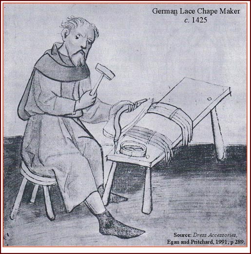
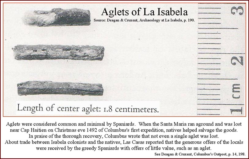
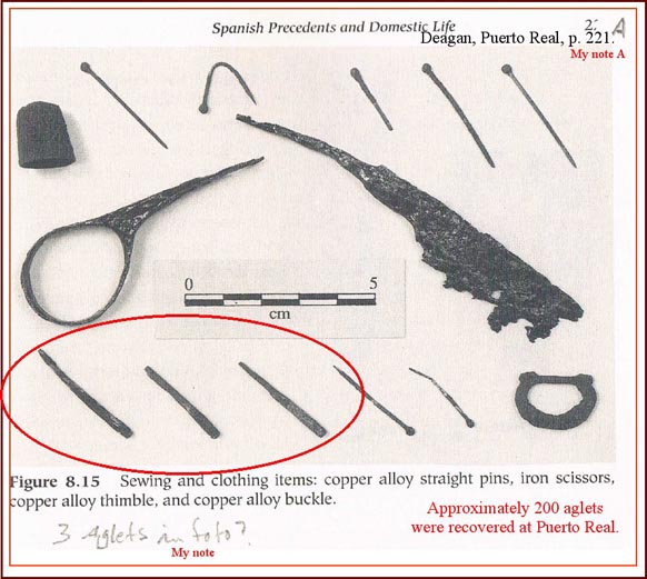
(29) Nugent Brasher, “Spanish Lead Shot of the Coronado Expedition: A Progress Report on Isotope Analysis of Lead from Five Sites," New Mexico Historical Review 85 (winter 2010): 79-81; “Francisco Vázquez de Coronado at Doubtful Canyon and on the Trail North: The 2011 Report Including Lead Isotopes, Artifact Interpretation, and Camp Description,” New Mexico Historical Review 86 (summer 2011):332. For an analysis of the isotope data, visit Chichilticale.com. The Piedras Marcadas, Jimmy Owens and Calabasillas isotope data presented in this report is from Alyson M. Thibodeau, John T. Chesley, and Joaquin Ruiz, “Lead isotope analysis as a new method for identifying material culture belonging to the Vázquez de Coronado expedition,” Journal of Archaeological Science 39, (2012), Table 1. In addition to being used as arquebus shot, Mexican lead was being crafted by 1540. At Piedras Marcadas, Matthew Schmader recovered a crafted lead cap determined by isotope analysis to be composed of lead from Guerrero. This example shows New World lead crafted in the New World. Also recovered at Piedras Marcadas were a piece of sheet copper and a crossbow bolthead, both composed of the same English copper. We propose that the Spaniards cold or warm hammered, or melted, copper objects, including at least one utensil fashioned from English copper, from which they crafted a bolthead. This is an example of Old World copper recycled and crafted in the New World.)
(30) We found two dome-head tacks at Doubtful Canyon. See: Nugent Brasher, “Francisco Vázquez de Coronado at Doubtful Canyon and on the Trail North: The 2011 Report Including Lead Isotopes, Artifact Interpretation, and Camp Description,” New Mexico Historical Review 86 (summer 2011): 346, Table 2, numbers 7 and 8. For nail types, see: Rosenberg & Kvietok, “A Guide to Historic Artifacts,” 1981, p 84-86, fig 70. This document cites Fontana, Bernard L., J. Cameron Greenleaf, Charles Ferguson, Robert Wright and Doris Frederick, 1962. In Johnny Ward's Ranch: A Study in Historic Archaeology. The Kiva 28(l-2):44-66. Concerning the Rosenberg & Kvietok document, in an email to the author on 3 March 2012, Richard Flint wrote, “This [publication] is an example of the so-called "gray literature." To my knowledge, the Rosenberg and Kvietok Guide was never formally published. It was informally distributed to colleagues in mimeographed form. I got an incomplete copy in 1991, I think, at a New Mexico Archaeological Council workshop on historical archaeology.” For a graphical display of Spanish nail types, see: Stanley South, Russell K. Skowronek, and Richard E. Johnson, Spanish Artifacts from Santa Elena, Anthropological Studies, no. 7 (Columbia: South Carolina Institute of Archaeology and Anthropology, University of South Carolina,1988), 329-30.)
(31) Frank Turley, “Report and Artifacts,” 16 April 2011 analysis conducted for author. Previously I reported finding an iron auger key at Kuykendall Ruins. From photomicrographic analysis by University of Arizona archaeologist David Killick, the iron was identified as bloomery. Killick wrote that bloomery iron was “used for a long time [after Coronado], though I doubt that there would have been much circulating in Arizona after about 1860.” Nugent Brasher, "The Red House Camp and the Captain General: The 2009 Report on the Coronado Expedition Campsite of Chichilticale," New Mexico Historical Review 84 (winter 2009): 18-19. The 2011 Turley report describes Bloomery iron as a “form that is no longer manufactured. It contains an extremely low carbon content… It has a stringy structure, because in the iron making process, bloomery or iron furnace, an impurity is retained in the iron, an iron silicate. When the iron is drawn out into bars, the silicate becomes the fine glass-like filaments, lengthwise, throughout the mass. Because of this lengthwise structure, the iron can split easily if forged at too low temperature.” My experience in the field is that bloomery iron expresses corrosion in elongate patterns and with flakes large in size relevant to the piece. Iron pieces are rarely recovered in the Southeast, where soil and water conditions quickly destroy bloomery iron – some Santa Elena pieces are conserved in trays of liquid. Iron pieces recovered at Piedras Marcadas are likewise heavily corroded from salts in the soil. The style of the iron hooklets found on the Minnie Bell site is strikingly similar to the hook portion of copper alloy garment clasps found at Piedras Marcadas.)
(32) In an e-mail to the author on 28 February 2012, Frank Turley contributed the following: "Eslabon giratorio is the noun for "chain swivel." [The chain swivel has two parts – a bulb-ended swivel loop and a swivel eye. Your piece is a swivel loop.] The swivel eye is not always present with the bulb-ended swivel loop. The loop can be attached to [other parts of horse tack] or it can be attached to something [entirely different], a padlock for example [like in the attached photo]. [The swivel eye] is stirrup-shaped… In Mexico, this is called a farolillo because it has the shape of a small lantern. The farolillo is called a swivel "eye" in English, and can properly be called the same in Spanish, as in ojo giratorio or ojo de eslabon giratorio. The assembly of farolillo and swivel loop in English is a "chain swivel." [Respecting the asiento], after the publication of our book [Marc Simmons and Frank Turley, “Southwestern Colonial Ironwork: The Spanish Blacksmithing Tradition,” (Sunstone Press, Santa Fe, 2007)], I found out that the technical name for the mouthpiece bar either side of the port is termed the "cannon."”)
(33) Marc Simmons and Frank Turley, “Southwestern Colonial Ironwork: The Spanish Blacksmithing Tradition,” (Sunstone Press, Santa Fe, 2007), 178, plate 3.) Presidio La Bahia existed at three distinct places beginning in 1722. Depending upon which location the coscojo in Plate 3 was found, it could date from as early as 1722 or after 1749. Aaron R. Norment, "An Examination and Analysis of the Metal Artifacts from Presidio San Sabá (41MN1), Menard County, Texas," Master's Thesis, Texas Tech University, 2007, p. 42; José Cisneros, “Riders Across the Centuries: Horsemen of the Spanish Borderlands,” (Texas Western Press, El Paso,1984) 63, 98-99. Microfilm of the original French version of Pierre Marie Francois de Pages account can be found at the University of Texas at San Antonio Library, F591.W478, frame numbers 4109-4112, reel 406. Spanish New Mexico: The Spanish Colonial Arts Society Collection, v.1, Edited by Donna Pierce and Marta Weigle, Museum of New Mexico Press, Santa Fe, 1996, page 131, plate 457. Our horse tack database showed bulb-headed swivels in 1622 and 1750, and rein chains in 1505 and 1757, and coscojos from c.1750 to 1815. We exercised caution when observing that coscojos could not be shown to exist in 1540, concluding that the Minnie Bell site horse tack could be dated only to the 1700s, thereby excluding Coronado as the bearer. Our inquiry of horse tack concluded that the “spike spur” is likely restricted to the sixteenth-century if found in specific parts of the United States. This spur style is absent a rowel (spiked spinner), and instead employs a shank sharpened into a spike to encourage the horse. Our database indicates that these spurs are first pictured in 1519 and last shown at the time of Phillip II from 1556-1598. For illustrations of spike spurs, see: Marc Simmons and Frank Turley, “Southwestern Colonial Ironwork: The Spanish Blacksmithing Tradition,” (Sunstone Press, Santa Fe, 2007), 28.); José Cisneros, “Riders Across the Centuries: Horsemen of the Spanish Borderlands,” (Texas Western Press, El Paso,1984) 3, 4, 11, 20, 21 and Christoph Weiditz, "Authentic Everyday Dress of the Renaissance: All 154 Plates from the "Trachtenbuch"; Dover Publications, Inc, New York, 1994, p 9, plates XLI, LI, CXXIII. For a photograph of a spike spur found at La Isabela, Dominican republic, see: Kathleen Deagan and José María Cruxent, Archaeology at La Isabela: America’s First European Town (New Haven, Conn.: Yale University Press, 2002), 242; and Kathleen Deagan and José María Cruxent, Columbus’s Outpost among the Taínos: Spain and America at La Isabela, 1493-1498 (New Haven, Conn.: Yale University Press, 2002 ), 174. Our database alerted us to a stirrup photographed in southeastern Arizona by John Madsen. Although Madsen did not consider this stirrup a Coronado artifact, it exhibits a similar form and function to stirrups found at La Isabela that date from December 1493 to abandonment in 1498. Archaeologists Deagan and Cruxent described these stirrups as “of the a la jineta form, associated with Arab horsemen of the fifteenth century” and “characterized by their boxlike form, with a broad footplate enclosed on two sides by wide sideplates… that permitted a surer footing, allowing greater control for the rider, whose knees would have been high and bent.” (Kathleen Deagan and José María Cruxent, Columbus’s Outpost among the Taínos: Spain and America at La Isabela, 1493-1498 (New Haven, Conn.: Yale University Press, 2002 ), 175-76. This style of stirrup is painted by Spanish art historian Pablo Martín Gómez in his sixteenth-century depictions of Spaniards in the New World. In addition, it also resembles, except for ornamentation, a c.1650 stirrup in the National Museum of Mexico collection. See John H. Madsen, “Spanish Artifacts, a Trail, and a Diary: An Eighteenth-Century Trail from Sonora to Zuni, New Mexico,” in The Coronado Expedition: From the Distance of 460 Years, edited by Richard Flint and Shirley Cushing Flint, University of New Mexico Press, Albuquerque, 2003, p 112, Fig 6.1; Pablo Martín Gómez, Hombres y Armas en la Conquista de México (Madrid, Espańa: Almena Ediciones, 2001), lámina 12; Antonio Cortes, Hierros Forjados, (Mexico City, Mexico: Talleres Gráficos del Museo Nacional de Arqueología, Historia y Etnografía, 1935), lámina 15.)
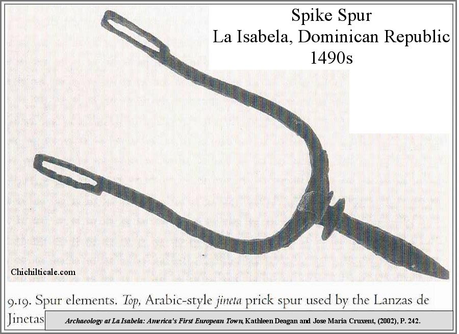
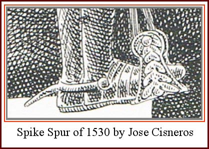
(34) “Cans in the Countryside”, Author(s): James T. Rock Source: Historical Archaeology, Vol. 18, No. 2 (1984), pp. 97-111, Published by: Society for Historical Archaeology; Fontana, Bernard L., J. Cameron Greenleaf, Charles Ferguson, Robert Wright and Doris Frederick 1962 Tin Cans. In Johnny Ward's Ranch: A Study in Historic Archaeology. The Kiva 28(l-2):67-78. A note in the preface reads, "John C. Greenleaf, associate dig supervisor and formerly a graduate student in anthropology at the University of Arizona, composed and wrote the section on tin cans and compiled virtually all of the data for the sections on history, miscellaneous metal artifacts, glass, buttons, bone, and shell, which were edited and in part re-written by Fontana.” Quote by Fontana from email to author 6 Aug 2011.)
(35) For button types, see: "An Overview of Nineteenth and Twentieth Century Button"; Juliann C. Pool, Research Notes Historic Sites and Material Number 1, Texas Parks and Wildlife Department, Austin, Texas, March 1991.)
(36) Michael A. “Smoke” Pfeiffer, “Notes for cartridge, cartridge cases and lead recovered at Big Dry Creek, New Mexico, 20 July 2011, report prepared for author. Pfeiffer’s report cited “One Man’s Trash is Another Man’s Treasure,” The Cartridge Collector’s Exchange, http://www.oldammo.com/april04.htm. The overwhelming majority of military cartridges were found on the north side of Big Dry Creek, while civilian cartridges were the rule on the south side. Pfeiffer provided evidence of the obvious military use of five of the cartridges. About casing numbers 3, 5, 9, 11 and 15, he wrote, “Finding crushed cases at any site is normal. People, livestock and wagons do a great job of making cartridges found on the surface flat and unusable. However, some of the cartridges were not only flattened, but also folded over. This type of deformation is deliberate.” Pfeiffer referenced an article that read in part: “It had been found that Indians were reloading inside primed .45-70 and .50-70 cartridge cases that were discarded by the Army. This was accomplished by inserting a percussion cap in a hole punched in the base of the copper case, filling the case with black powder, and inserting either a newly cast or a reclaimed bullet. In an effort to put an end to this practice, the Secretary of War ordered that officers exercise 'great care' to prevent Indians from procuring any empty cartridge cases that were thrown away. This was General Orders No. 13, issued February 16th, 1876.” In support of this article, Pfeiffer provided General Orders No. 13, issued by the War Department Adjutant General’s Office, Washington, 16 February 1876: “It appears from reports of officers serving on the plains, as well as from experiments conducted by the Ordinance Department, that the empty metallic cartridge-shells for the Springfield carbine and musket can, after being fired, be used an indefinite number of times by refilling and capping. Great care will therefore be exercised by all officers to prevent Indians from procuring the empty shells thrown away by the troops after firing, either in action or at target practice. By Order of the Secretary of War: E. D. Townsend, Adjutant General.)
(37) Meader Hill hosted the stone ruins of two aboveground pre-historic masonry buildings. One building is round and the other is rectangular. While the hill surface is strewn with black obsidian and fragments of "exotic" rocks, including large jasper cores, most noteworthy is the total lack of potsherds on the surface. We observed one obsidian "dart-sized" projectile point while examining the surface. No groundstones were observed. Iron was absent except for two pieces of bailing wire and a tin can; the majority of the metal was represented by fourteen spent lead slugs and seven spent cartridges of post-1900s age.)
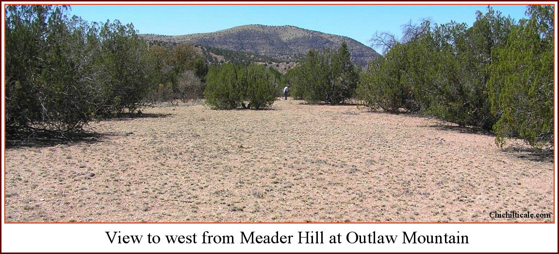
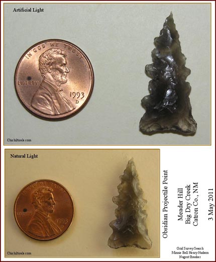
(38) Marc Simmons and Frank Turley, “Southwestern Colonial Ironwork: The Spanish Blacksmithing Tradition,” (Sunstone Press, Santa Fe, 2007), 101, fig.1.)
(39) Cut nails were the rule on the north side of Big Dry Creek, while wire nails prevailed on the south side. For an illustration of colonial Spanish handles, see: Marc Simmons and Frank Turley, “Southwestern Colonial Ironwork: The Spanish Blacksmithing Tradition,” (Sunstone Press, Santa Fe, 2007), 119, plate 4.)
(40) For a discussion of the Coronado camp model, see: Nugent Brasher, “The Coronado Exploration Program: A Narrative of the Search for the Captain General,” in The Latest Word from 1540: People, Places, and Portrayals of the Coronado Expedition, ed. Richard Flint and Shirley Cushing Flint (Albuquerque: University of New Mexico Press, 2011), 250.)
Transcription of Letter dated 28 October 1775 from Fray Silvestre Vélez de Escalante to Governor Pedro Fermín de Mendinueta.
Escalante Letter, 1775
final transcription
Richard Flint and Nugent Brasher
March 2012
[p.19]
paso a exponer las noticias, que respecto a el transito de Sonora a estas / Provincias he podido adquirir.
Por lo que he sabido de la campańa general de ańo de 47 y de las particulares que / hazia Gila ha hecho los Zunis, juzgo assequible, y practicable este transito. Pues ca- / minando 4 dias al sur de este Pueblo de Zuni se encuentra un rio pequeńo que / en dicha campańa nombraron de San Francisco y se compone de dos arroyos, de los qua- / les el uno corre de nordeste a sudoeste y el otro de norte al sur. este es un poco / mayor que el primero, y por su caja se atraviesa con facilidad la sierra / de Gila. Juntos, ya forman el dicho rio de San francisco que en el cańon de la sierra si- / gue el rumbo de norte al sur, y acabado el cańon toma el de oeste. A poca dis- / tancia entra en un pequeńo valle, que con sus humedades hace mui ameno / y fecundo, en el que hai varias Rancherias de Apaches, que lo cultivan, y con el / beneficio de el riego cojen mucho maiz amarillo. seis leguas al sur de es- / te vallecito esta el rio de Gila, que por aqui dista 16 leguas de el sitio que / llaman de las Mimbres. Esto he sabido por Don Bernardo de Miera / vecino de esta Villa, que en dicha campańa general iva en calidad de ingeniero / y de Capitan miliciano, y anduvo todo lo referido desde las Mimbres a Gila / rio de San Francisco salinas de Zuńi, y Pueblo de Acoma. Quien tambien dice / que de dichos valle, y rio de san Francisco se volvieron los Pimas gentiles auxi- / liares, y que asseguraron, que por la otra orilla de el Gila al rumbo de oeste / llegarian en dos dias a la cańada honda, en que tenian sus habitaciones, / y que de el Presidio de terrenate solo dista dia, i medio de camino. Con esta / relacion convienen las de los Zuńis, que han llegado hasta la sierra de / Gila, de las que solo indicare la principal, y mas verosimil originada / de una campańa, que con ellos hizo ańos pasados su teniente Alcalde Don / Marcial Barrera. Para cuia mayor exactitud, luego que recibi el or- / [...]
[p. 20]
exactitud. ^luego que recibi el orden de vuestra seńoria ocurri por carta a mi actual Prelado Vice Custos / el Reverendo Padre Fray Mariano Rodriguez de la torre, que entonces era / ministro de ellos, y se hallaba en este Pueblo, y supo todas / sus resultas quien (^sin) conforme a quanto me havian / dicho antes los Zuńis, se digno escribirme diciendo / Que el ańo de 54 haviendo salido dicho Don Marcial Bar- / rera en seguimiento de unos Apaches con otros dos espańoles / y cien Yndios Zuńis de este Pueblo, y haviendo caminado / dos dias, y medio hazia el sur, dio con la Rancheria de / Capitan Chafalote Apache gileńo, destruidola, quitando / la vida a ochenta y dos personas, de que se componia, y tra- / jo un Yndio mestizo christiano, que estaba cautivo (^de) ^en ella, y / se llamaba Manuel thomas Y que este le refirio, que / iendo su amo el Padre Don Joaquin Rodriguez Capellan / del Presidio de terrenate a una confession le salio al / encuentro la expresada Rancheria, y que haviendo mu- / erto al Padre y a la escolta, que llevaba, a el lo cautivo, y ven- / dados los ojos se condujo en solos 6 dias al mismo sitio, / en que logro su libertad. A que ańaden los Zuńis haver oi- / do a dicho Manuel thomas, que a poca distancia del sitio, / en que lo hallaron, esta un rio a cuyas orillas viven / unos Apaches, que no salen a parte alguna, ni tienen / caballos, pero si mucho maiz de color amarillo. Por lo que / parece ser este el rio de San Francisco Y finalmente, que / por otro lado no mui distante del mismo sitio hay / un cańon (^grande) ^estremo, y fragoso al principio, pero despues / dilatado y ameno en que otra porcion grande de Apaches / tienen las caballadas, y ganados, que roban. Lo que da / a entender ser este sitio el que los espańoles llaman / valle de Gila. De todo lo qual se deduce, que no es mui / dilatado, ni dificil de (^prevos) frecuentarse el proyectado / transito de la Sonora, y Pimeria alta a la nueva / Megico, y Moqui. El que si se logra desembararan / de enemigos, y poderse frecuentar sin riesgo de sus / acostumbrados insu(b)ltos, sera de suma utilidad / a los habitantes de una, y otra parte. [...]
Translation of Letter dated 28 October 1775 from Fray Silvestre Vélez de Escalante to Governor Pedro Fermín de Mendinueta.
Escalante Letter, 1775
Final Translation
Richard Flint
April 2012
[p. 19]
I proceed to conveying reports I have been able to obtain regarding the route from Sonora to these provinces.
According to what I have learned about the general campaign in the year [17]47 and about the details of what the Zunis have accomplished [in traveling] in the direction of the Gila [River], I think that this route is workable and practicable. To wit: by traveling 4 days towards the south from this pueblo of Zuni, one encounters a small river, which during this campaign they named the San Francisco. It is formed by two streams, of which the one runs from northeast to southwest and the other from north to south. The latter is slightly larger than the former. By means of [this river's] trough one traverses the Gila Mountains with ease. Together [these two streams] form the aforesaid San Francisco River, which within the canyon through the mountain range continues a course from north to south. When [the canyon] ends, it takes a course to the west.
After a short distance it enters a little valley, which with its moisture makes it very conducive to plant growth and fertile. In [this valley] there are several settlements of Apaches who cultivate it. Taking advantage of irrigation, they harvest a great deal of yellow corn. Six leagues to the south of this little valley is the Gila River, which is at this point 16 leagues away from the place they call "de las Mimbres."
This I have learned from don Bernardo de Miera [y Pacheco], a vecino of this villa [of Santa Fe], who went on the aforesaid general campaign in the role of engineer and militia captain. He traveled [through] all [the places] mentioned above from las Mimbres to the Gila [River], the San Francisco River, Zuni Salt Lake, and the pueblo of Acoma.
[The same man] also states that the unconverted Pima auxiliaries returned from the aforesaid valleys and San Francisco River [to their starting point]. They asserted as true that [traveling] by way of the opposite bank of the Gila [River] in a westward direction in two days they would reach a deep canyon in which they have their dwellings. [That canyon] is only a day and half of travel away from the presidio of Terranate.
The [reports] of the Zunis who have come from the Gila Mountains agree with this report. Concerning these [things] I will point out only the first part and what appears to be the true beginning of a campaign which their lieutenant alcalde don Marcial Barrera made years ago with them.
For better accuracy, after I received the directive
[p. 20]
from your lordship, I conferred with my present prelado, the Reverend Father fray Mariano Rodríguez de la Torre, who then was minister to them [the Zunis] and was in this pueblo [of Zuni]. He was aware of all of its [the campaign's] results and agreed with what the Zunis had told me earlier.
He found it worthwhile to write to me, stating that in the year [17]54 the aforementioned don Marcial Barrera had gone forth with two other Spaniards and a hundred Zuni Indians from this pueblo in pursuit of some Apaches. When he had traveled for two and half days towards the south, he encountered the settlement of Captain Chafalote, a Gila Apache, and having destroyed it and killed eighty-two people who were occupying it, he brought out a Christian mestizo called Manuel Tomás, who had been a prisoner there.
This [man] related to him that when his master, Father don Joaquín Rodríguez, the capellán of the presidio of Terranate, had gone to hear a confession, [the people of] the aforesaid settlement came forth to oppose him. They had killed the father and [the members of his] escort and took him [Manuel Tomás] captive. With his eyes blindfolded he was transported in only 6 days to that same place, where he gained his freedom.
The Zunis added to this that they had heard from the aforesaid Manuel Tomás that at a short distance from this place where they found him is a river, on both banks of which live some Apaches who do not leave there, nor do they have horses, but they do have a great amount of yellow corn.
Because of this, it seems that this is the San Francisco River and finally that on the other side, not far from this same place, there is an extremely large canyon [that] is rough at the beginning but later widens and is suitable for planting, in which another large group of Apaches have their horse herds and livestock that they steal. What is understood [by this] is that it is a place the Spaniards call the "valle de Gila."
From all of this he [Rodríguez de la Torre] infers that it would be neither time-consuming nor difficult to routinely use the proposed route from Sonora and the Pimería Alta to New Mexico and Hopi. That [route], if it were successfully cleared of enemies, would be possible to use routinely without risk of their usual attacks. It would be extremely useful to the inhabitants of both areas. (1)
(1) Biblioteca Nacional, México, Archivo Franciscano, Legajo 10, no. 28a, Excerpt from Letter, fray Silvestre Vélez de Escalante to Gov. don Pedro Fermín de Mendinueta, Zuni, October 28, 1775, signed copy. From phtographic copy in the Center for Southwest Research, Zimmerman Library, University of New Mexico. Transcription of the letter was a collaborative effort of Richard Flint and the author. Translation is by Richard Flint.
The exact birth date of the Big Dry Creek wagon stop remains uncertain. None of the various accounts of the 1885 Soldier’s Hill ambush mentioned a stage stop; instead they referenced the Siggins ranch house. Records and circumstances strongly suggest that John D. Lee established the station and drove the wagons. An 1889 “plat map” identifies the stop as the “John D. Lee House & Stage Station.” An 1890 newspaper reported J. D. Lee as the “former driver and supposed owner” of the stage line, and as “a man of very windy ways” who left Silver City in November 1890 owing money to “almost everyone in the country.” Three years later Lee had returned and was in the process of using timber from Mogollon to build a station, a general merchandise establishment, a residence, and a hostelry on Big Dry Creek in November 1893. By February 1895 Lee had completed his project and opened it to the public. One newspaper reported “a good table, good beds, good liquors and cigars and everything to make one comfortable, is to had at the new station on Dry Creek.” One year later Lee fled again: “J. D. Lee, former proprietor of Lee’s Station left for Texas. He left many sorrowing creditors. [Some of these] tried to capias the fellow at Deming but were too late as he had gone. This is the second time Mr. Lee has left the vicinity in the same manner.” Apparently Lee truly left the vicinity. John D. Lee’s widow remarried in Temple, Texas 17 December 1902.
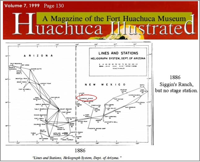
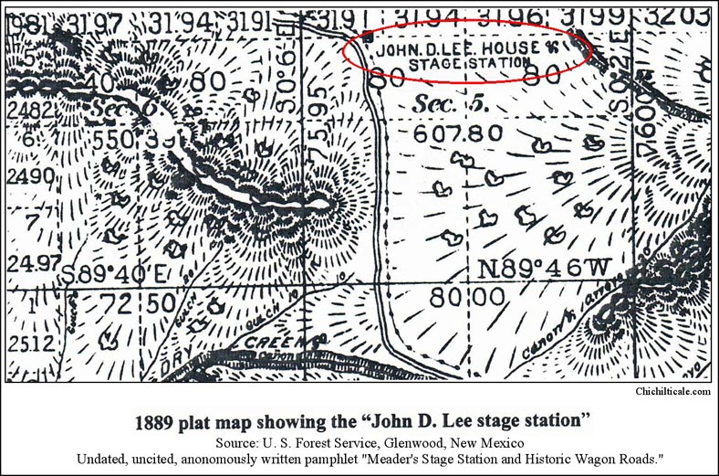
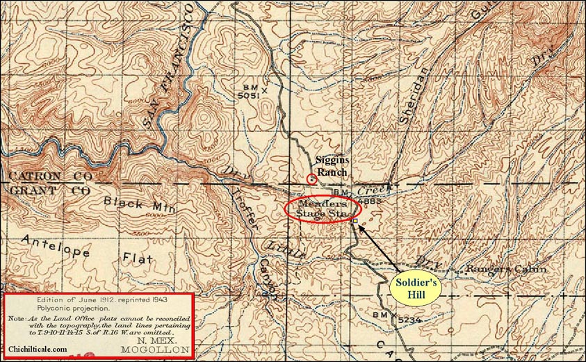
At some time between 1886 and 1905, the Meader family began operating the station. Agnes Zeralda Snider, daughter of James Chapin "Pa" Meader and his wife Susan Elizabeth "Ma" Meader, reported that the family arrived at Big Dry Creek from Alma in 1904. The following year Snider acquired the land through the Homestead Act. Snider described that the Meaders “ran a hotel stage stop,” and that the operation “delt their food and lodging with the teamsters and stage riders.” Snider said the “house contained eight or nine rooms which were sufficient to serve the travelers… All of the people would sit around a big table that accommodated 8 to 10…” and eat meals prepared by Agnes or “an employed Chinaman.” Snider told of a “café store” and a garden. Records show that the Meader family operated the station in 1907, the year the first automobiles provided the mail service from Silver City to Alma. The “Meaders Stage Station” is shown and named on the 1912 Mogollon topographic map published by the United States Geological Survey. (1)
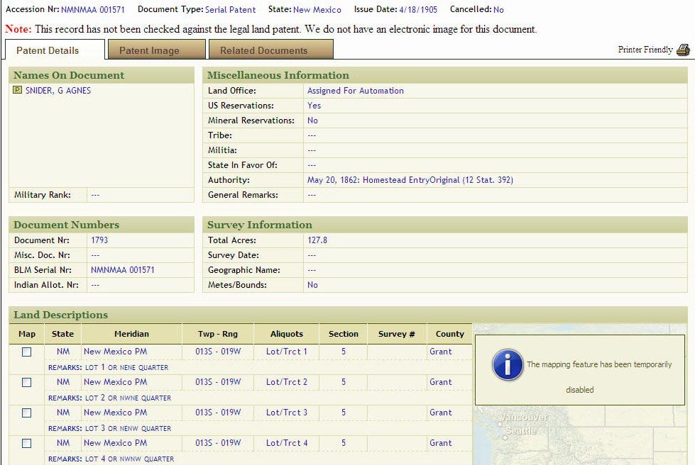
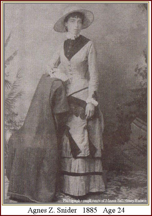
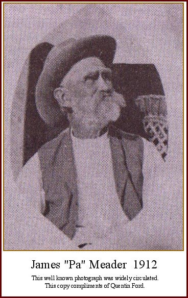
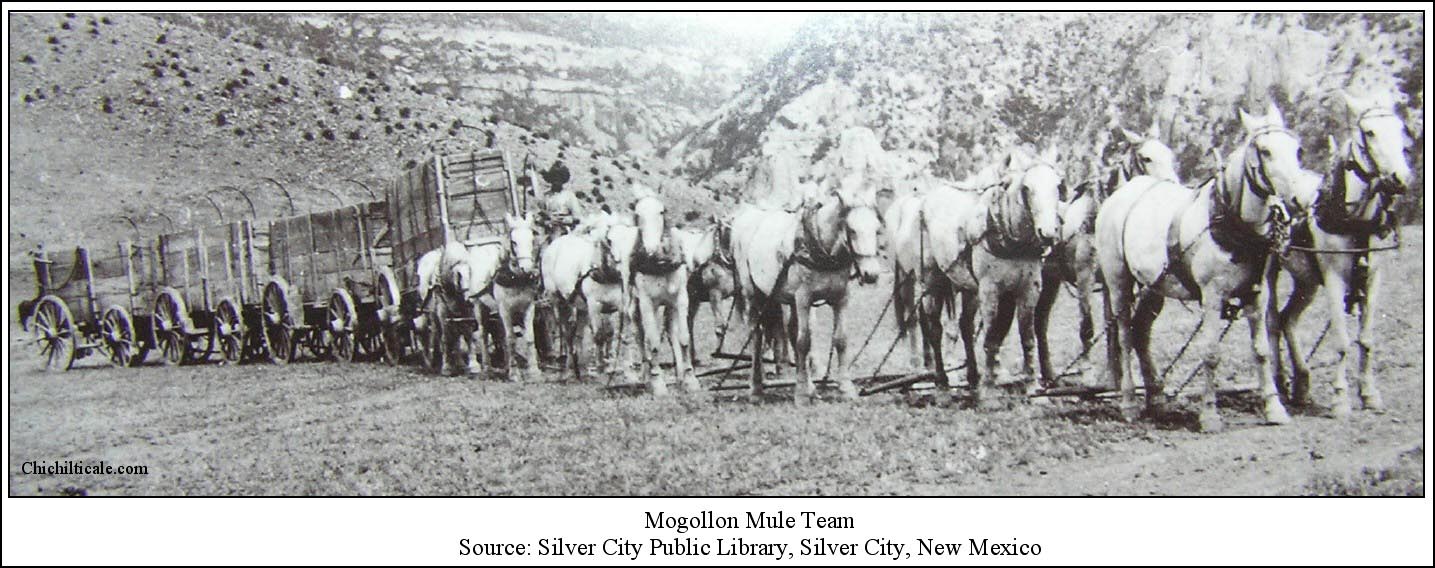
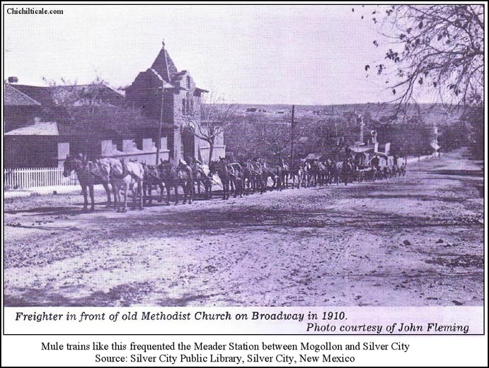
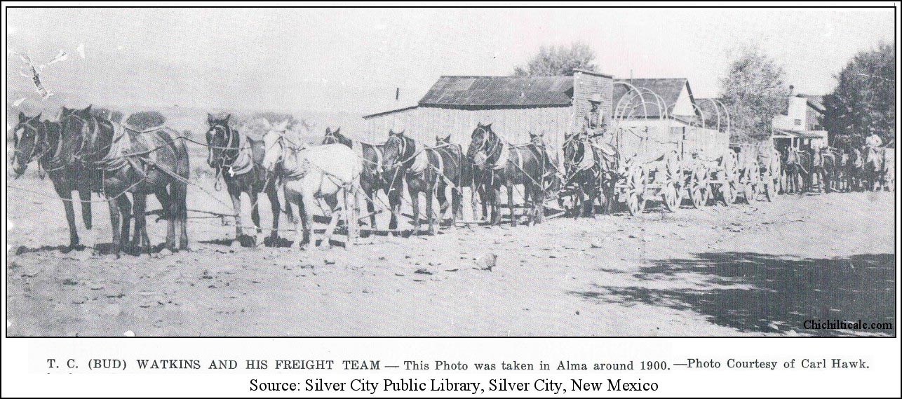
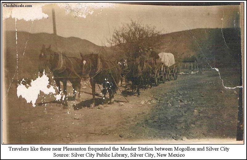
The earliest land ownership deed along Big Dry Creek is dated March 1885 when Isaac Siggins bought his first parcel from the USA and founded the Slash SI Ranch. Siggins continued to buy property from the USA and to expand his ranching operation until ill health forced him to Phoenix, Arizona, where in died in October 1905. Although only a tiny portion of his land was deeded to Siggins, by 1919 the SI Ranch spread over 100 square miles along the Río San Francisco from the Arizona border on the west to Mogollon Baldy in the Gila Wilderness on the east. The outfit ran about 1,500 steers in any given year. In 1943 the ranch was partitioned into three pieces. John Henry bought the southwestern portion, and Curly Traynor purchased the western parcel. Jim Henry bought the original ranch house headquarters on Big Dry Creek. (2)
In addition to the permanent presence at Big Dry Creek of the Lee and Meader station and the Slash SI Ranch, temporary occupation of the site existed at various times. Soldiers from Fort Bayard likely began camping there as early as 1866, as did Mormons and drovers. Frontiersman and WS Ranch manager James H. Cook mentioned “Captain Smith’s command encamped on Dry Creek” in the summer of 1885. On 19 December of that year, a mile south of the camp, Apaches ambushed departing troops, killing five people. The bodies of four deceased soldiers and Dr. Thomas John Claggett Maddox were taken to the Siggins Ranch prior to burial. The ambush site became known as Soldier's Hill. As warfare involving the Apaches diminished in 1886, the soldiers, after July of that year, left their camp at Big Dry Creek and returned to Fort Bayard. In 1899 Fort Bayard ceased to be an active military post. (3)
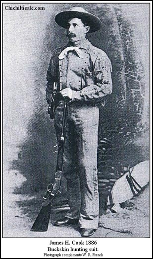
The 1905 homestead patented by Agnes Snider, by observation in 2012, contained three known houses. On the south side of Big Dry Creek are the ruins of the wooden structure built by John D. Lee and later the stage station operated by the Meaders. This house burned in 1922 when Bert Snider, son of Agnes Snider, lived there, but was not at home. Nearby, likewise south of the creek, are the ruins of a smaller building constructed of round “river rock.” Minnie Bell recalls no standing building at the site. This structure, fabricated from nearby creek stone, may have been Lee’s first residence and wagon station. About a half mile distant to the east, on the north side of the creek, stood a third building, constructed of adobe by Bert Snider after the 1922 fire. The structure remained uninhabited, lacked doors and windows, and was used for apple storage. In 1929 Snider bought a house in Silver City. The following year Jess and Mary Hines, and Mellie Mattison, bought the Snider homestead. They developed the adobe house and operated it as a county rest home for the elderly called the County Farm, but known locally as the "Poor Farm." In December 1936, the famous lion hunter and mountain man Ben Lilly died there. Today that structure is the home of Tom and Red Humphreyville. (4)
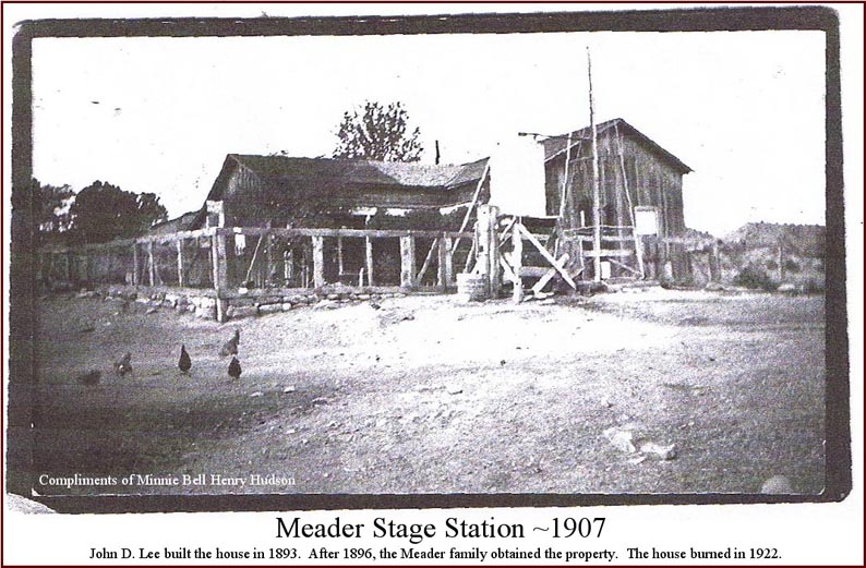
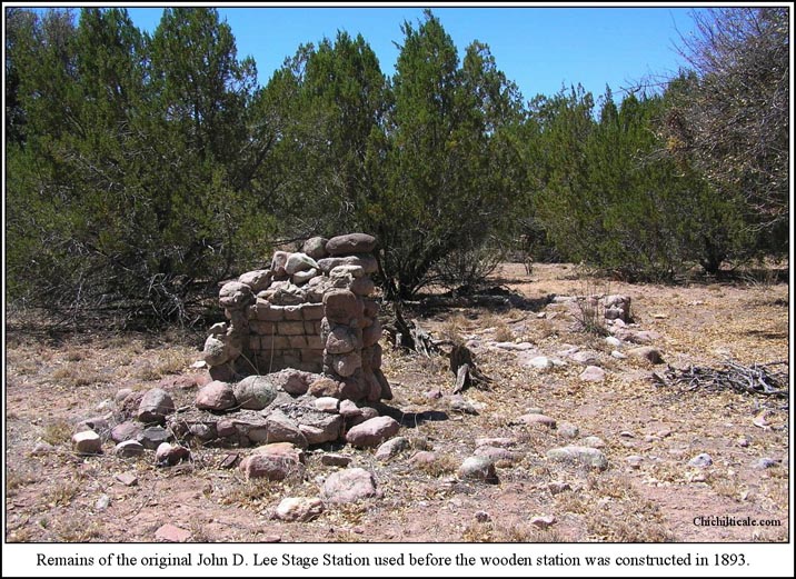
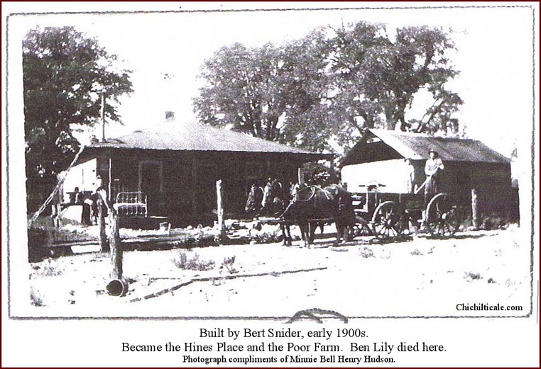
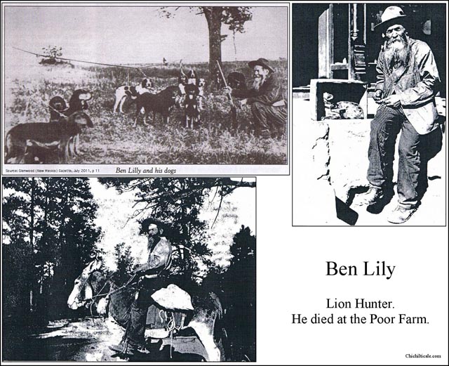
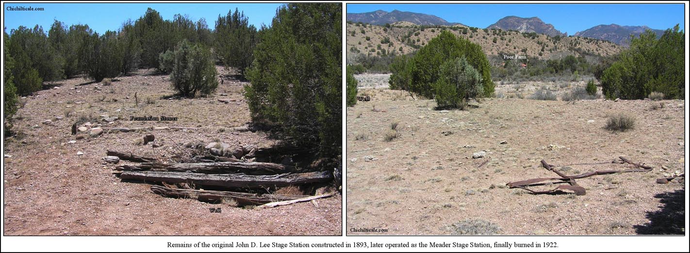
There are two burial sites at Big Dry Creek. Headstones south of the creek show that the Bert and Lily Snider family lost a baby boy in June 1919 and a baby girl in July 1920. Two other headstones mark the graves of Jenny May Lizer and Edris May Lizer, the former born in 1885, the latter in 1906, with the younger passing on in 1925 and the older in 1928. Headstones north of Big Dry Creek represent three men. Commodore P. Elliott died 13 August 1894 at age 40. Known as “Old Man” Elliott because of his “long experience on the frontier,” French described him as “foreman, entire cow outfit, and general factotum at the Siggins Ranch.” Reporting on the ambush at Soldier’s Hill, Lieutenant Fountain wrote that the sight of “old man [Elliott], bare-headed with white hair flying, was picturesque and inspiring, [and he led men] in the most gallant manner.” Another headstone records that Chas Snow died on 13 December 1895. The headstones of Elliott and Snow are unfashioned local rock and appear to be the chistled script of the same artisan. A third headstone, distinct and imported, records that John A. Graves was thirty-five years and eight months old when he was killed on 14 June 1897. (5)
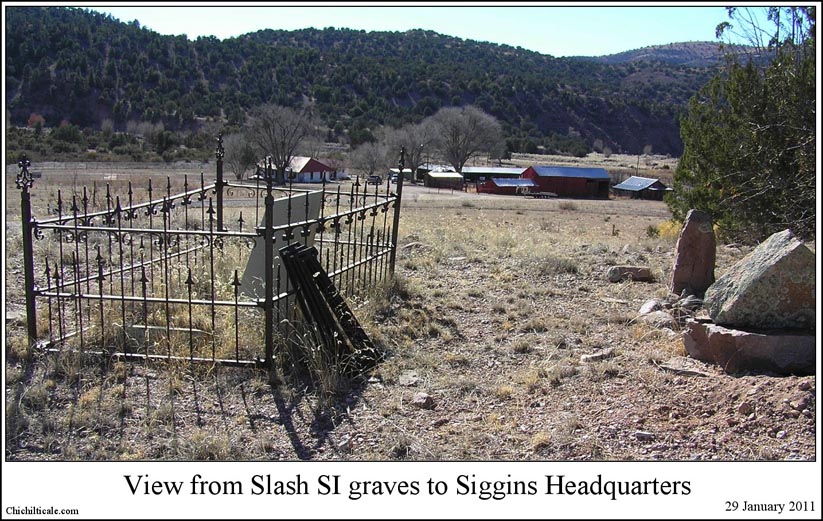
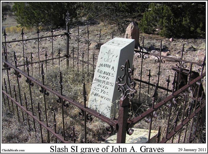
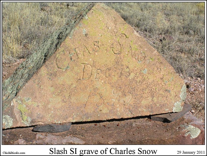
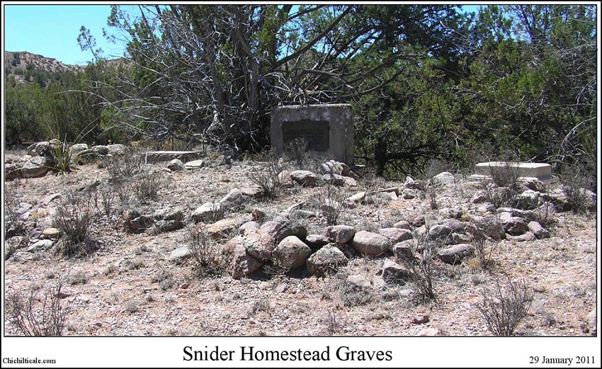
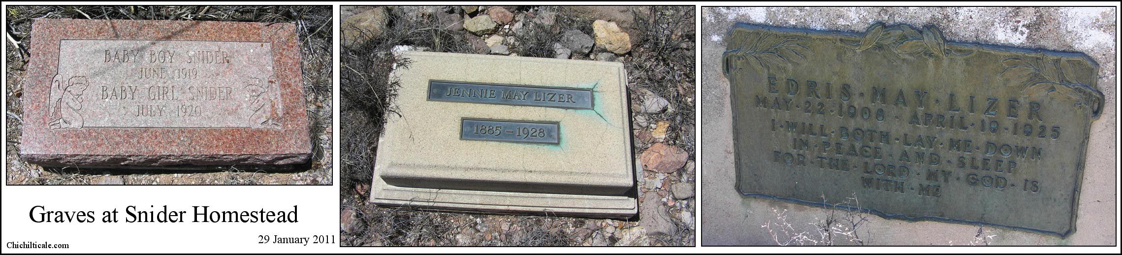
(1) An undated, uncited, anonymously written pamphlet titled “Meader’s Stage Station and Historic Wagon Roads,” distributed by the United States Forest Service, contains an “1889 Plat Map” that shows “John D. Lee House & Stage Station” located at the Meader site. The Silver City Enterprise reported on 28 November 1890 that “J. D. Lee, the former driver and supposed owner of the Mogollon stage line, who skipped so unceremoniously last week, owes almost everyone in the country. He is a man of very windy ways… He has gone to Texas.” Lee returned. That same newspaper reported on 28 November 1893 that “J. D. Lee, the Mogollon stage man, is building a station on Dry Creek, not far from Siggins’ ranch. He has also in contemplation the erection of a general merchandise establishment in connection therewith, and later on will be built a residence there. Carpenters are already on the ground, and work will be commenced before long. The timber for the new settlement will be brought from Silver Creek. The new hostelry will accommodate the freighters who now travel through that desolate section.” (William H. Mullane, This is Silver City, New Mexico, 1888, 1889, 1890, copyright 1965, p 46; The Silver City Enterprise, This is Silver City, New Mexico in the Years 1892 and 1893, copyright 1971, p 55.) Silver City Enterprise 22 Feb 1895, 27 March 1896; Silver City Independent 23 Dec 1902. James Chapin Meader was originally from New York state and his wife Susan Elizabeth Stubbfield was from Virginia, where they were married. With at least one daughter, Agnes, the couple arrived in Alma, New Mexico in 1879. The following year in April, the Apaches attacked Alma in the locally famous siege of Roberts Cabin. The Meader family was there, and as a result of their performance in battle, especially true of Susan, the couple became heroes. In 1882 they built the Hotel de Brunswick in Alma. Susan helped establish the first Alma school in 1886 and also served as the midwife in the region. They became known as Pa and Ma Meader, and James gained more renown as the "Father of Mogollon." Pa died on 25 January 1914 at nearly age 79, and Ma died in Silver City in 1917 at age 82. For an interview with Mary Agnes Snider, granddaughter of Agnes Zeralda Meader Snider, great-granddaughter of Susan Meader, see: The Glenwood Gazette, November 2009, 14-15. Agnes Snider was interviewed and taped by Lou Blachley. Subsequently, Agnes’ granddaughter Agnes Haymes assisted R. Morgan Lyman in producing an account of the Meader family. See: R. Morgan Lyman, “The Battle of Robert’s Cabin and The Dry Creek Store, as told by Agnus Snyder,” Term paper for Dr. Giese, June 6, 1976; Silver City Public Library, Family files, Meader Family. For claim of 1886 property purchase by J. C. Meader in his obituary of 27 January 1914, see: Silver City Public Library, Family files, Meader Family. The first attempt to carry mail by automobile between Mogollon and Silver City happened in 1907; from Mogollon to the Meader station required three and a half hours. (Mogollon Diary 1877-1977, Bill Rakocy and R. S. Jones, editors, Río Bravo Press, El Paso, 1977, 166, 168.
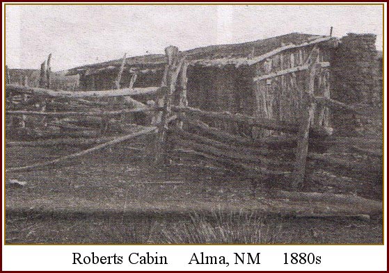
(2) Minnie Bell Henry Hudson provided me numerous title abstracts, patents, warranty deeds, mortgages, court filings, tax documents, probate records, bills of sale, releases, notices, receiver's receipts and brand certificates, all pertaining to landownership in the Big Dry Creek area from 1885 forward. See also Minnie Bell Hudson, Home on the Range: Her Story & Recipe Roundup (Payson, AZ: Git A Rope! Publishing, Inc, 2006), 9-34. Lee, Siggins and Meader had a potential neighbor by 1900. Richard L. Powel patented his homestead on the south side of Big Dry Creek west of and adjoining the stage station and south of and adjoining the Siggins property on 8 February 1900. However, there is no evidence or memory that a homesteader house ever occupied the site, despite the requirement of such by the Homestead Act.
(3) James H. Cook,
(4) The fire that destroyed the wooden house built of timber from Silver Creek by John D. Lee and then used as a stage station by Lee, Meader, and Snider was reported in the Silver City Independent, 10 October 1922. The purchase by Bert Snider of a house in Silver City was reported by the Independent on 16 July 1929. For information on Ben Lily, see: Lily, Ben, Silver City Public Library, Southwest History Drawer.
(5) William French, Some Recollections of a Western Ranchman, New Mexico 1883-1899; Argosy-Antiquarian,Ltd. (New York, 1965) 2 vol., p. 96, v.1; Jerry Eagan, “Studying the Ground: Searching for Soldier’s Hill, site of a renowned Apache ambush in 1885” Desert (Silver City, N.Mex.) Exposure, February 2007.
