Coronado at the Río Bermejo
The 2019 Report on the Coronado Trail from Río Frio to Cíbola
Nocturnal darkness had brightened to gray dawn as four Sonoran Indians hurried along the muddy footpath beside the Río Bermejo. These principales from the Río Sonora valley had traveled the previous year with fray Marcos de Niza, guiding him along a trail thousands of years old. Keeping pace with the Sonorans were four Nahua indios amigos (Native allies) from central Mexico, members in standing of the Coronado expedition. Now these Americans led European invaders north toward Cíbola.
Well behind the swiftly moving Americans that Tuesday morning in July 1540 followed Spanish maestre de campo (field commander) don García López de Cárdenas and his fifteen horsemen. Weary and hungry, they rode silently, having seen three of their starving companions die from eating poisonous plants at Hardcastle Meadows the previous Friday. Alongside these Spaniards trotted a dozen lean, mean dogs. These riders were charged with scouting ahead of the advance party that was breaking camp back at the red river. Following the mounted Europeans at a short distance paced four sweepers, a group of Sonorans and Nahua amigos responsible for securing the rear. In this formation moved the train of invaders—mounted Spaniards sandwiched between striding Americans—all on their way to Cíbola.
Previously, I have published maps illustrating my predicted trace of Capt. Gen. Francisco Vázquez de Coronado’s route from Vácapa, Sonora, Mexico, to Hawikku, New Mexico, United States, in 1540. While these maps lack definition for the trail north of Hardcastle Gap, most problematic for the trail prediction was that I could not offer a single sixteenth-century artifact between the Minnie Bell site and Hawikku. Given that my team had conducted several searches between Minnie Bell and Hardcastle Gap, all to no avail, mostly due to geological or cultural conditions at the available prospective sites, we hoped to mitigate our lack of artifacts by focusing our exploration on finding Coronado north of the gap. This report concerns that exploration.1
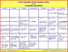
The written records concerning Coronado’s route north of Hardcastle are some of the most thorough and detailed of the expedition because of the events surrounding the assault on the native pueblo of Hawikku and the subsequent legal proceedings against Coronado. An array of expedition members, all except one being part of the advance party, provide sometimes-conflicting descriptions of the events immediately preceding the Spaniards’ assault on Hawikku. Using these documents, I reconstruct the route and identify the dates and locations of the Spanish-reported camps at the Río Frio, Poison Plant, the Río Bermejo, and Dangerous Pass. In addition, I identified the Plateau camp.2 The expedition members recorded dates in the Julian calendar, as shown on my maps and included in some of my figures. The Julian calendar differs from the Gregorian (the present international standard) by ten days. Julian 7 July is Gregorian 17 July. In this report, I retain the Julian notation from the sources, but also include the Gregorian date in parentheses.
After crossing the Río de las Balsas on Tuesday, 29 June (9 July) 1540, the expedition traveled to the Arroyo de la Barranca and the Río Frio before arriving on Friday at the camp, mentioned by both Jaramillo and Coronado, where a Spaniard and two Moors died from eating poisonous plants. Jaramillo reported, “Then from here [Río Frio] we traveled through a pine forest, almost at the end of which we found a stream and small flow of fresh water, where we arrived after probably another day’s travel. . . . At this stream and place a Spaniard called Espinosa and two other persons died from poisonous herbs.” Coronado wrote, “Some of my Indian allies died, as well as a Spaniard named Espinosa and two Moors, who died from eating a certain plant.”3
Coronado recorded the events from Saturday 3 July (13 July) to the following Monday: “From this place [Poison Plant camp] I had the maestre de campo, don García López de Cárdenas, go one day’s journey ahead of me with fifteen horsemen to reconnoiter the land, and so that they might straighten the route.” After complimenting López de Cárdenas, complaining about the hard travel, and describing some vegetation, Coronado continued, “Hardly a single Indian was met for another day’s journey.” The next day, however, ameliorated Coronado’s frustration, when “from a place there [Rio Bermejo camp] four [Cíbola] Indians came out peacefully, saying that they were there because they had been sent to that unsettled place to tell us we were welcome, and that on the next day all their people would be coming out along the trail with food. The maestre de campo gave them a cross.”4 I interpret that Coronado camped at Cow Springs and Plateau during his first and second nights away from Poison Plant. His third night was memorable—the river ran red and the Cíbola Indians appeared. This was the fabled Río Bermejo camp.
Jaramillo recounted that from the Poison Plant camp, “we went in two days on the same general course, but rather to the north[west], to another stream we named Bermejo. Here we saw one Indian and [another pair]. . . . From here we traveled in two days to that pueblo, the first one of Cíbola.” Jaramillo recalled a two-day journey from Poison Plant to the Río Bermejo, where the Spaniards met three Cíbola Indians. His account supports a two-day journey from the Río Bermejo to Hawikku.5
Regarding the Cíbola Indians at the Río Bermejo, Castańeda, who was not a witness, placed them “eight leagues from Cíbola at a river which they named the Río Bermejo because its water flowed muddy and bright red. In this river there were whiskered carp like those in Spain. It was here that the first Indians were seen. They were two, who fled and went to spread the news [of the Spaniards’ arrival]. The next day at night, two leagues from the pueblo, a number of Indians taunted them in a way that one who knows the land does.” By inference Castańeda, like Jaramillo, placed Hawikku two days from the Río Bermejo, where the Cíbola Indians were spotted.6
Advance party–member Juan Troyano, testifying in legal proceedings subsequent to the expedition, corroborated that Cíbola Indians appeared two days before Hawikku, that is, at the Río Bermejo. Troyano recounted that when the expedition “arrived near Cíbola,” Coronado sent a message to that pueblo “with some Indians who were natives of Cíbola and who, a day previously had come voluntarily to the army. . . . Those Indians departed and did not return. The following day, the general sent fray Juan de Padilla and other clerics . . . to talk to the Indians, [but they were not] willing to come to peace.” Padilla’s plea and the subsequent attack occurred on Wednesday, 7 July (17 July) 1540. So the Cíbola Indians had come voluntarily to Coronado two days before the assault, on Monday, at the Río Bermejo. Troyano, Castańeda, and Jaramillo all report Cíbola Indians at the Río Bermejo and a travel time of two days from that river to Hawikku.7
On Tuesday, 6 July (16 July) began the usage of a phrase that would recur frequently in the records: “arrived near Cíbola.” During the 1544 legal proceedings against Coronado and the other leaders of the expedition, all of whom were charged with mistreatment of the Natives, the captain general expanded his 1540 account of the events: “When he had arrived near Cíbola, he ordered don Pedro de Tovar and Melchor Diaz to bring him an Indian from among those who were walking near a lake [laguna]8 . . . and they brought two or three Indians.” Through an interpreter that he had brought from the Valley of Corazones, Coronado communicated that if they rendered obedience to Spain no harm would come to them. The Cíbola Indians departed accompanied by two Nahua Indians from the expedition and likely by at least two Sonoran Indians. When Coronado arrived about three leagues from Cíbola he found only the Nahuas and the Sonorans, who told him the Cíbola Indians were “not willing to come to peace.”9
Advance party–member Pedro de Ledesma, who belonged to Coronado’s household added further detail to the account. In 1544, he recounted to the visitador (special investigating judge) that when Coronado reached a point three leagues from Cíbola, “about thirty Indians came with food. . . . The Indians wandered about looking over the army like men who had come to see what people were in the camp [real] and how they were organized. When the Spaniards arrived at where they were expected to sleep, they discovered that all those Indians had left.” This report reinforced Coronado’s claim that the Cíbola Indians (at the Río Bermejo) had told him, “The next day all their people would be coming out along the trail with food.” It also demonstrated that the Spaniards did not camp where the Cíbola Indians gave them food, and supported the testimony that the Indians had left Ceadro Spring by the time Coronado arrived on 6 July (16 July).10
Advance party–member Juan Troyano, adding more information, testified that Coronado sent a message to Cíbola “with some Indians who were natives of Cíbola. . . . Those Indians departed and did not return.” Domingo Martín, also in the advance party, testified, “When he had come within three leagues of Cíbola, two or three Indians from that province” communicated by signs with Coronado, who told them “that they should tell the people of the pueblo to offer peace. So these Indians went away.”11
The accounts of Coronado and Ledesma recall a meeting with the Cíbola Indians preceding arrival at the camping spot. Coronado wrote in 1540 that after that meeting, he ordered Cárdenas to scout ahead. In 1546, in a sworn statement, avanzada (lead rider) Cárdenas recounted the event: until about three or four leagues from Cíbola, there had been no skirmish with the Indians. On arriving at that spot, Cárdenas went ahead with eight or ten horsemen and saw some Cíbola Indians, who had climbed a cerro. He rode forward alone toward where those Indians were making peace signs. After the Spaniards offered gifts, some of the Cíbola Indians came off the cerro, touched hands with Cárdenas and received trade goods and a cross. Cárdenas testified that the Indians left peaceably for Cíbola, carrying word that the Spaniards came amicably.12
Cárdenas dispatched a messenger to Coronado to alert him of the meeting on the cerro. Coronado wrote that Capt. Hernando de Alvarado “returned to tell me that some Indians had come peacefully and that two of them were waiting for me with the maestre de campo. Hence I went to them.” Cárdenas testified that he remained at the cerro until Coronado arrived with the advance party. There Coronado set camp. Coronado expected to find the Cíbola Indians at Ceadro, but Cárdenas reported that they had already left, leaving only the Spaniards, the Nahuas, and likely the Sonoran Indians13. This sequence of events explains why witnesses Troyano and Ledesma, who saw Cíbola Indians at the Bean Patch, did not see them at Ceadro Spring. They were traveling with Coronado and the Indians left before Coronado arrived.
From the Cerro camp three leagues from Cíbola, Coronado “sent the maestre de campo don Garcia Lopez de Cárdenas in advance to reconnoiter” and to “see whether there was any hazardous passage ahead.”14 Cárdenas reported that he found a “mal paso” (bad pass), where there were “peńas” (boulders). Coronado described the place as “a paso that appeared rugged in some boulders,” and he ordered Cárdenas to “sleep at the upper end of [the pass].”16 Testimony to the visitador in 1544 placed mal paso, Dangerous Pass, one-half league east of the main camp. Castańeda reported Dangerous Pass two leagues from Cíbola.17 Cárdenas testified that “with a few men,” he guarded the pass, but Coronado claimed that “twenty to thirty” soldiers composed the force at Dangerous Pass. Riding with the advance party, Ledesma later testified “about twenty horsemen” supported Cárdenas at the pass.18
At this point, the Cíbola Indians became homeland defenders. Advance party–member Domingo Martín, one of the soldiers with Cárdenas, told the investigating judge in 1544, “When they had established a bivouac in a woodland [monte] and night had fallen, the Indians struck him.”19 Coronado reported that the Natives attacked Cárdenas after a quarter of the second watch was over, but Ledesma recalled the attack came after a quarter of the first watch.20 Regardless of the Spanish reports, the homeland defenders undoubtedly carefully planned their approach in order to strike before a sliver of the waning crescent moon had risen.21 Irrespective of the exact hour, Cárdenas sent a rider through the moonless night to alert Coronado of the hostilities. By daylight, after leaving a rear guard commanded by Juan Gallegos at the Cerro camp, Coronado led the advance party to assault Hawikku on Wednesday, 7 July (17 July) 1540.22
Cobbling together these conflicting, contradictory, and confusing reports required sifting through all the Spanish accounts and deciding what data to accept, reject, and ignore. For the purposes of my exploration, I considered all the documents as individual accounts, then blended or synthesized them to produce a subjective interpretation designed exclusively to indicate possible locations where Coronado camped or rested. These predicted locations became my exploration leads, the traps I hoped to run.23
My proposed trail from Hardcastle Gap to Cow Springs presented few puzzles. From Cow Springs north, however, the route remained undetermined. By splicing together topographic maps to make a map ten by fourteen feet on my wall, and by contouring and coloring those maps to unmask the relevant topography, I recognized an anomalous surface feature that was too large to see unless many maps were viewed as one. Ultimately, I recognized this anomaly as the most likely route of Coronado.
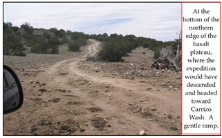
The feature is a basalt flow that creates a narrow flat surface serving as a natural passage through otherwise eroded, rugged canyonlands filled with tangles and undergrowth—terrain through which driving livestock is impractical. My exploration team suspected that campsites as old as Clovis, to as young as Coronado, and as recent as twenty-first century hunters were likely located along the platform. An Apache trail marked on a U.S. Army map from 1876 follows the basalt plateau. My team and I surmised that for Coronado, as for modern ranchers, the plateau is the natural and common route through the landscape, used for thousands of years, first by walkers, then riders and drovers, and now trucks, for today the dirt roads follow the basalt flow.24
Three sites of interest surfaced during our examination of maps and images—all were lakes that existed at Coronado’s time and that still hold periodic rainfall and serve as locations of water for livestock. These lakes exist during the summer monsoon and likely held water when the advance party and the following army traveled over the plateau in July and October, respectively. I predicted that Coronado had camped at one of these tableland lakes.
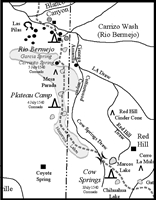
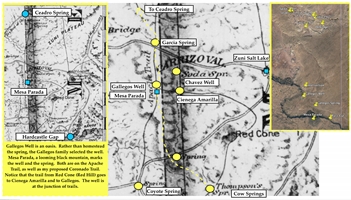
My version of the written mélange opens on the morning of Monday, 5 July (15 July) 1540, when maestre de campo Cárdenas and fifteen horsemen, along with their canine companions, departed the Plateau camp beside the lake. Indios amigos and their Sonoran counterparts led the way, as well as followed behind. Ahead of the party stretched flat, open range that extended to the looming, hunkered, and black massif of Mesa Parada, the landmark at which the riders and runners aimed their steadfast pace. At the north end of the plateau, on the east side of Mesa Parada, Cárdenas and company dropped off the basalt into Gallegos Well, a drainage that still flows today. The spring water refreshed the travelers before they continued north over a trail that had become muddy, slick, and more twisted but that guided them into Carrizo Valley at Garcia Spring.
The initial invaders to enter Carrizo Valley were the Nahuas and Sonorans. The first to see these Americans were other Americans, residents of Cíbola, who were monitoring the expedition and providing homeland surveillance from the vantage of a ruined pueblo. After observing the arriving outsiders followed by the Spaniards and their dogs, these locals hurried to the west toward Las Pilas. The surprised Europeans witnessed the flight and reported it.25
When Coronado joined Cárdenas later that day, he saw a river flowing red, muddy water. This was the first such river water seen—the Río de las Balsas flowed brown, like all the other runoff water previously witnessed by the expedition. This was the Río Bermejo.26 Coronado reported meeting the first Indians there. Supporting Coronado’s recollection is that of Troyano, who mentioned these as Cíbola Indians who “had come voluntarily to the army.”27
On Tuesday morning, 6 July (16 July) 1540, avanzada Cárdenas with his horsemen and Native allies departed the Río Bermejo camp. After leaving the red river through a break in white bluffs, the riders were surprised to see in the distance behind them several towering buttes glowing in the oblique sunshine. In this way, with the travertine cones of Las Pilas at their backs, the men-in-metal moved inexorably toward Cíbola.
Cárdenas covered about thirteen miles to the Bean Patch, where he came upon Cíbola Indians. After Coronado arrived and observed the situation, he sent the Natives away, escorted by Cárdenas, with instructions for their pueblo. After about ten miles, point rider Cárdenas arrived at Ceadro Spring beside the Río Zuni to see Natives who had climbed a cerro. Coronado arrived afterwards. The advance party reached Ceadro Spring after traveling about twenty-three miles over mostly open, level terrain. The party set camp there the evening of 6 July (16 July) 1540.
Coronado dispatched Cárdenas to reconnoiter the imposing Río Zuni canyon. Cárdenas found Dangerous Pass and secured it. Being a professional soldier, Cárdenas likely considered proper protocol for establishing a camp, especially given the tenuous circumstances28. That night, before the sliver of a moon rose, the homeland defenders from Cíbola struck the Spaniards. Cárdenas sent a rider with notice to Coronado, and on Wednesday morning 7 July (17 July) 1540 the Spanish force moved to invade, assault, and seize Hawikku.
Coronado’s headquarters remained in captured Cíbola. Word passed to those remaining in the Río Sonora valley and the following army departed there for Hawikku, arriving in mid-October 1540. The following army likely used the same campsites and parajes (rest stops) as had the advance party, plus additional ones. This reasoning places the following army at Carrizo Valley, Bean Patch, and Ceadro Spring. Other travelers who stopped at these campsites include small parties of expedition riders outbound to Mexico and returning from there.29
Following the excursion to the Great Plains and to Quivira in 1541, Coronado and his retreating army once again arrived at Hawikku. There Coronado amassed the single largest force that had marched together, therefore likely the slowest. Finally, in mid-April 1542, the expedition was ordered back to Mexico, and the rear units of the Spaniards departed Hawikku for the last time. Among the first three potential camps on this exodus were Ceadro Spring, Bean Patch, and Carrizo Valley. Castańeda offers a compelling description of the salida (exit): “Now leaving astern the seven pueblos of Cíbola, the last to be left [Hawikku], the expedition set out. . . . For two or three days’ journey the natives never stopped following the expedition, behind the rear guard, in order to pick up a little of the baggage [fardaje].”As the Spaniards retreated, they likely shed their unwanted materials, and the Cíbola Indians following them picked up the superfluous items.30
This reconstruction of the retreat presents three locations where all travelers along the trail either camped or rested: Ceadro Spring, Bean Patch, and Carrizo Valley. Moreover, it targets three sites where the Spanish metal-bearers likely discarded personal items. Even given that Indians picked up the discards, the written evidence suggests that Spaniards deposited an inordinate number of artifacts along the trail and at parajes. This circumstance elevates the prospective nature of the three leads by providing more objects to be found, thereby reducing the risk of finding nothing.31
Best practice fits a prospect to the proven or presumed model. In favor of the proposed trail between Hardcastle Gap and Hawikku, and therefore the leads along it, is its north-south orientation. My proposed trace of the Coronado Trail illustrates that the dominant northerly trend of the trail continued from Mexico into the United States. From Ispa (Arizpe) in the Río Sonora valley through Cananea, Sonora, Mexico, to Lewis Spring, Arizona, United States, the trail stretches almost due north. Jaramillo’s turn toward his right hand occurred at Lewis Spring when the expedition followed Government Draw into the Sulphur Spring Valley, bearing northeast through Soldiers Hole, Chichilticale, Apache Pass, and Doubtful Canyon to reach Hidden Valley on the Río Gila.
There the route returned to the north, as Hidden Valley is almost exactly due south of Hawikku. Leaving the Río Gila, the northbound expedition followed Blue Creek to Dutch John, then to Raines cinder cone, the Minnie Bell site, the Río Balsas crossing and to Pueblo Park. At the park, the travelers struck northeast once again, trending to La Barranca, Delgar, and the Río Frio (Río Tularosa). At Apache Creek, the expedition left the Río Frio and resumed its northerly route to Hardcastle Gap.
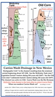
The trail continued northward through the gap before turning northwest toward Marcos Lake and Cow Springs, located on the modern New Mexico–Arizona state line. From those water holes the route bore almost due north along the Arizona side of the state line to Carrizo Valley and the Río Bermejo. From that valley, the trail headed mostly north to the Bean Patch, Ceadro Spring, Dangerous Pass, and finally to Hawikku. This dominant northerly course, interrupted only by two veers to the northeast and one to the northwest, represents the most direct route for drovers traveling from Sonora to Hawikku in 1540.
Previously I have written about Coronado camp models. Of foremost importance is locating camps where Coronado artifacts can be recovered. This priority raises the question, “If Coronado were truly here, could we find any evidence of him?” If that answer is affirmative, then the follow-up question is, “Can we get permission to explore the site?” To plot possible camp models along our proposed route, we first examined maps and aerial photographs that illustrated topography, geology, and soil. At the same time, we fully utilized Google Earth. This examination of the various documents produced a number of sites for ground reconnaissance between Hardcastle Gap and Hawikku.32 One day’s travel north from Hardcastle Gap are Marcos Lake and Cow Springs, both located in rich grassland near the New Mexico–Arizona state line. At either spot, Coronado would have found all the essentials for a campsite, with Cow Springs clearly the most attractive.
From Cow Springs, the landscape dictates the route—a narrow, level basalt plateau extends north from the springs for about twenty miles, offering pedestrians a high, flat, clear, straight passage through otherwise difficult country. Seasonal lakes offered camps along the plateau. Historic travelers dropping off the north end of the basalt plateau found lush Gallegos Well, a good environment for a camp. From there the trail continued northward for only a short distance before reaching Carrizo Valley, with its numerous springs, and a wash through which flowed red muddy water after rainfall. The valley offered a perfect camp. Leaving Carrizo Valley, the trail followed the wash for a couple of miles before turning north toward the Bean Patch lagunas, with a ruined pueblo perched on a ridge in the hills southeast of the lakes. At the Bean Patch, travelers descended into the Río Zuni valley and the narrow canyon holding Ceadro Spring, a good spot for a camp, and the entrance to Dangerous Pass. Through the pass and on the mountains across the plains sat Cíbola, represented by Hawikku, sought by Coronado.
My proposed trail has always addressed Coronado’s entrada to Hawikku, placing him in the Carrizo Valley, with Carrisito and Ceadro springs as targets. In 2011, I published that my exploration model addressed the trail through Carrizo Valley, but that I had not yet completed my field surveys, thereby delaying any mention of specifics. Our exploration at Minnie Bell had ended by December 2011. At that time, we were unable to obtain permission to explore some targets, and other targets required fieldwork, especially those from Carrizo Valley to Hawikku. In February 2013, I published that I had no Coronado exploration in progress, confessing the same in February 2017. The time of inactivity measures over five years.33
These searches take a long time and lots of patience and one never knows when the hunt has truly ended. In the spring of 2017, because of my interest in water on potential property purchases in Apache County, Arizona, I met ranchers who owned private land that I considered prospective for Coronado presence. The ranchers gave me permission to search and to publish—so once again the hunt for Coronado was on. This is my report of that hunt.
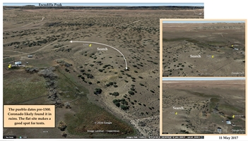
Water and grazing land served as magnets to U.S. homesteaders, and Carrizo Valley offered a surfeit of both. Antonio Gonzales received his 160 acres on 30 December 1884; he was the first of five pioneer families to arrive in the valley. Gonzales selected for his homestead a large spring gushing from a travertine cone. The water overfilled a pool and created an oasis. The spring lay under a low cliff. On the flats above the cliff perched pueblo ruins containing potsherds. Gonzales was not the first occupant of the valley; the initial occupation was 1000–1325. Across Carrizo Wash on the opposite side of the valley sat another pueblo of the same period. For centuries, these two observation posts served as vantages to monitor the passage of humans and game animals through Carrizo Valley, the ruins offering evidence of the route’s antiquity.34
Rather than build a stone house, Gonzales, shepherding his flock of sheep, likely moved into the ruins of the pueblo by 1879. Four more homesteaders followed him into the valley by 1920, the last two both named Garcia. The current local name for Carrizo Valley is Garcia Ranch, and the local name for the spring at the Antonio Gonzales homestead, one of the few still flowing in Carrizo Valley, is Garcia Spring. Ergo, the last homesteaders are the ones chosen by history to memorialize.35
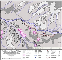
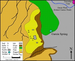
The setting of Carrizo Valley fits the Coronado camp model: the site includes prehistoric presence, an old, established trail, a grazing valley, and an elongate stream with nearby fire rocks and firewood (see map 3). In addition to prehistoric artifacts and vantage pueblos in the valley, evidence of a pre-homesteader trail is two-fold: First, I met Jeff Waseta (A:shiwi), from Zuni, New Mexico, at Hardcastle Gap in August 2007. He told me that the place was a traditional A:shiwi hunting ground, reached from Carrizo Wash. Second, the 1877 map of Lt. J. C. Mallery and J. W. Ward, “compiled from the latest authentic data,” shows an Apache trail extending southward from Ceadro Spring through Garcia Spring and onto a basalt plateau to an unnamed spring, likely Coyote Spring.36
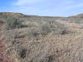
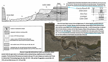
There are two readily apparent streams in Carrizo Valley, one younger and active, the other older and dead. The present Carrizo Wash—immature, wide, and deeply incised, its bottom vegetated by scattered thickets of salt cedars—slices along the northern side of the valley. When the wash flows, the water is red and turbid, painted by the colorful upper Triassic mudstone over which it drains. Following the basalt plateau to Carrizo Valley from Cow Springs, Carrizo Wash offers the first river water north of Hardcastle Gap that runs red. Modern, active Carrizo Wash is the youngest watercourse through Carrizo Valley.
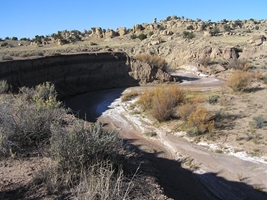
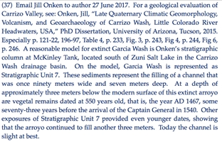
South of the modern wash hides an older channel that is now extinct. During its time as the principal drainage in the valley, that stream likewise flowed red water. I named it Garcia Wash. Recent and ongoing geological studies conducted upstream of Carrizo Valley in the Carrizo Wash watershed by geoscientist Jill Onken found physical evidence that supports Garcia Wash being the principal drainage through Carrizo Valley in 1540. Onken writes, “The arroyos of this age [Garcia Wash] were largely infilled by AD 1540.” Such infilling would have produced a mature river as opposed to an immature arroyo like modern Carrizo Wash.37
Onken includes in her study evidence from oral history, reporting that modern arroyo cutting began after the U.S. Civil War. The process started with the arrival in significant numbers of settlers who plowed fields, utilized wheels, and grazed domestic animals. These intrusions created roads that became gullies and produced a denuded and eroded landscape. Supporting this chronological interpretation is the fact that homesteaders settled Carrizo Valley between 1879 and 1920, the same time the wagon and military roads from Colorado Bridge and St. Johns to Zuni Salt Lake followed Carrizo Wash through Carrizo Valley. These homesteaders and their farming and pastoral enterprises likely witnessed and contributed to the incision of Carrizo Wash, lending credibility to oral history accounts from the late 1800’s. The absence of any homesteads traversed or cut by modern Carrizo Wash suggests that the downcutting was obvious by 1879, when Antonio Gonzales arrived.38
Geological evidence further supports the oral history. Geoarchaeologist Kirk C. Anderson observed that the floodplain above the incised wash contains fluvial forms “such as meander levees, as well as sand and gravel bars. These features attest to a fairly recent occupation of the floodplain by stream action, and it seems probable that Carrizo Wash downcut through the prehistoric floodplain during the late 19th or early 20th century. In support of this, barbed wire fences and other fence posts dangle across the arroyo, in places a distance of more than 30 meters. The emplacement of these fences probably pre-date the most recent downcutting episode.”39
Onken’s and Anderson’s evidence supports the interpretation that if Coronado were at Garcia Wash in 1540, he arrived when that stream was mature. Since 1540, that stream filled and became extinct. It was replaced some two thousand feet north (609 m) by modern, immature Carrizo Wash, which formed around the end of the nineteenth century and is currently the principal drainage through Carrizo Valley. Coronado and his men saw a stream that is now buried and gone, replaced by Carrizo Wash, which Coronado never saw.
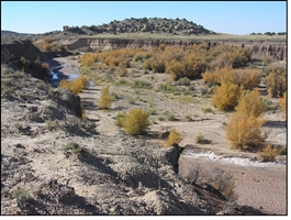
For exploration purposes, I used Castańeda’s report of the Río Bermejo during the monsoon in mid-July 1540. He described muddy, bright red water that was habitat to catfish. From Castańeda’s description, skimpy as it is, I expanded my visualization of the proposed location and developed an exploration concept. In my view, Coronado’s campers enjoyed an elongate watercourse bordered by cottonwoods. The slight banks of the river dropped gently to the willows along the water’s edge. Other than during the monsoon, the stream presented a serene, mature-river, riparian habitat. Regardless of the season, Garcia Wash offered a traveler’s oasis: shade, coolness, water, fish, soft ground, and firewood. Enhancing the site even further, several springs flowed near the river, each one surrounded by lush vegetation. In particular, the environs of Garcia Spring offered a hilltop site above the pools of water. There were many spots for bivouacs, too many for exploration purposes. The salient question regarding Carrizo Valley or Garcia Ranch was not where Coronado camped, but rather where among the many possible locations the team could find evidence of Coronado’s presence.
Carrizo Valley, elongate east to west, is bordered by white Dakota sandstone rimrock that inspires the descriptor sierra blanca by some old timers in the region. Travertine cones, the locations of extinct springs, rise above the brush carpet; these orange mounds are sometimes betrayed by struggling cottonwoods or a single tree trunk, large and dead. Many springs flowed until the 1970s, when local coal-driven power plants began to use the water as coolant. These springs, bubbling in 1540, were obvious targets of the Coronado expedition.
A challenge to my team’s exploration was that exhumed surfaces in the Carrizo valley are infrequent and sporadic. The floor is composed of thick clay and silt. Fine dust rises everywhere a foot sinks into the powder, and running cattle produce silt storms. For example, in one spot, I heard a strong signal from my metal detector. About a foot down in the silt, I uncovered a shotgun shell. In such areas, thick sediment would cover a sixteenth-century metal object to an undiscoverable depth. In other spots, the silt covering the floodplain clay was as thin as a half-foot, well within a metal detector’s effective range. Overall, however, the thick silt dampened the efficiency of metal detecting and was therefore a constraint to exploration for Coronado.
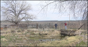
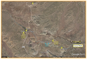
The valley was far too big to examine without some point on which to focus the search. Carrisito Spring was at best a dubious candidate for successful exploration due to the lack of exhumed surfaces, the sediment overburden, and the homesteader metal extant there. On the other hand, Garcia Spring offered high exploration potential: Our interpretation predicted that some of the potential camp remained uncovered by silt, sand, and the modern ranch, lending hope that Coronado’s metal artifacts would be in range of our metal detectors, which could reach no more than two feet maximum in that area. Garcia Spring rose to the top of the team’s leads in Carrizo Valley. Our exploration began there.
Two nights before Coronado assaulted Hawikku, his expedition entered Carrizo Valley from the south. On the flats above Garcia Spring, a ruined pueblo served as a vantage to inspect and monitor Carrizo Valley. After seeing the intruders, for whom they had waited in expectation, three Cíbola Indians burst from the ruins and fled to the west toward Las Pilas, rushing the news to their leaders. Later four Indians came to visit. Coronado camped where those first Indian visitors appeared, at a river flowing vermilion-colored water and named the Río Bermejo by those who were there.40
This red river is the now-extinct Garcia Wash, the main channel through Carrizo Valley at the time of Coronado. Extinct Garcia Wash is the historical Río Bermejo, and Garcia Spring is the historical camp where Coronado first received Indian visitors. Compelling artefactual evidence supports this claim of a Coronado presence. The Ewen Test proposes an effective assessment for a sixteenth-century Spanish site in the New World. First, the landscape described in historical documents should be discernible in the modern setting. Second, an assemblage of artifacts, not just a single piece, ought to be recovered at the site, and, third, the artifacts should be utilitarian European pieces, not exclusively trade items. According to the Ewen Test, however, meeting all the standards is not proof that the site was a sixteenth-century Spanish camp, but that it is a contender for the one pursued. Failing to disprove the hypothesis would allow its continued use to guide future research in the area.41
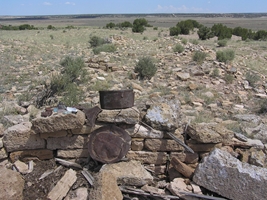
The painted desert was scorched and parched that 19 May 2017 morning when our team first strolled onto the flats above the bosque de alamos of Garcia Spring and began to swing our metal detectors. I was living my seventy-third year – almost thirteen years had passed since my propitious introduction to the Flints and Coronado. It quickly became clear that the first homesteaders had occupied the pueblo ruins rather than build their own stone-slab house. The crew found copious metal litter—wire, rotten tin, cast-iron stove pieces, handles, barrel straps, crushed kitchenware, cast-iron wagon parts, shell casings, cut and wire nails, screws—plus thousands of pieces of broken homesteader glassware and prehistoric potsherds and lithic chips. The search site was a mélange of human presence spanning at least one thousand years.
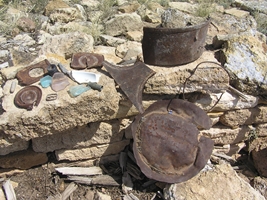
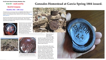
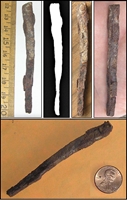
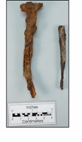
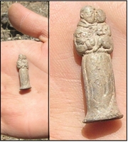
Luck endorsed our search that morning. After only thirty minutes, the team detected a piece of forged wrought iron that exhibited the taper, cross-section, corrosive character, form, function, and craftsmanship of a sixteenth-century iron spike. This find offered evidence that the Coronado expedition camped on the homestead of Antonio Gonzales. With enthusiasm and optimism, the team continued the search until it had thoroughly covered the flats on the bench above the spring. In addition to the spike, the search uncovered a forged, wrought iron, flat-head nail with the cross-section, corrosive character, form, function, and craftsmanship of a sixteenth-century nail. These two pieces were the only wrought iron discovered; all other iron was cast. Also unearthed was a small, cast-lead religious figurine. This extraordinary artifact provided the means to determine the source of the lead, thereby offering a clue to the bearer’s possible identity.
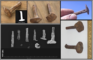
During the exploration at Garcia Spring, the team grid-searched the exhumed flats at the pueblo ruins, the silt plain around a travertine cone beside the extinct Garcia Wash, and along each bank of that wash in the area of the spring. After these grid-searches, the crew randomly hunted on hilltops and slopes around the spring, on silt plains in the valley around the spring, and in the vegetation surrounding the spring itself (see map 4). The only exhumed surfaces on the site today are the pueblo flats. Otherwise the various surfaces were either unconducive to preserving iron objects within range of our detectors, were composed of lithic rubble, or were places where modern objects were recovered at one-foot depths in floodplain clay. With the exception of the pueblo flats and the area immediately around the modern ranch, the exploration found nothing besides modern wire, lead conical bullets, and cartridges. With nothing to add to the pieces uncovered on the pueblo flats, the team sent the three discovered artifacts to laboratories to determine the isotope ratios of the lead figurine and the iron individualities of the nail and spike.
Renowned historical and forensic blacksmith Frank Turley examined the iron spike and nail uncovered at Garcia Spring. He observes that both pieces exhibited “very well the striations [and] the fibrous structure of wrought iron.” Wrought iron was the only iron available to Coronado’s expedition so, based solely on iron type, the Garcia pieces cannot be excluded from Coronado. Can the iron pieces be excluded from later bearers? Archaeologist David Killick “doubts that there would have been much circulating in Arizona after about 1860.” However, Turley extends the life of wrought iron by noting that it “was available in the U.S. until 1900, and to a very limited degree after 1900.” Turley’s dates suggest that the wrought iron could be as recent as the beginning of the twentieth century and therefore available to homesteader Gonzales.42
While attempting to exclude the wrought pieces from the homesteader era, I visited the historical museums in St. Johns and Springerville, Arizona. No wrought iron was exhibited in any collection; the homesteader iron on display was all cast. The scores of nails found at Garcia Spring were all cut nails or wire nails; the machine-cut nails dated from the Civil War to the late 1880s, when they were replaced by wire nails. These industrially produced nails are distinct from the forged wrought nail and spike that my team unearthed.
Turley describes the Garcia Spring wrought nail as “forged square on the shank and then hammer chamfered on the corners.” He further remarks, “European nails were all made with a square-sectioned tapered shank.” Maritime archaeologists John R. Bratten and John Worth of the University of West Florida maritime studies program x-rayed and examined the Garcia pieces. They write, “There is certainly nothing that suggests that they are not 16th century. As you probably know, there isn’t a great deal of difference for the next couple of hundred years. Your spike is really more comparable to our nails than our spikes. Your nail is closer to our tacks.”43
The Garcia nail strongly resembles nail heads and upper shanks from La Isabela, Dominican Republic; Puerto Real, Haiti; and Doubtful Canyon, New Mexico. Likewise, the Garcia spike exhibits the taper and proportions of such implements extant in sixteenth-century collections. They are both consistent in style with similar pieces dated to the sixteenth century and therefore cannot be excluded from the sixteenth century.44
The lead figurine appears to be a petite statue of San Cristóbal. Traditionally, San Cristóbal is shown “with long robes girded at the waist by a belt, carrying in his arms, and at times over his heart, Christ his majesty. Cristóbal is by rule a giant; Christ often appears nude, extending his hand, holding a ball surmounted by a cross.” Particularly significant is that San Cristóbal is the patron saint of travelers; the team could easily imagine a Coronado expeditionary carrying the figurine.45
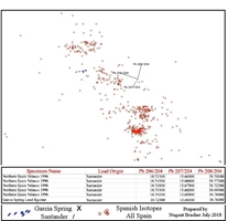
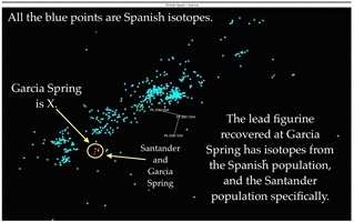
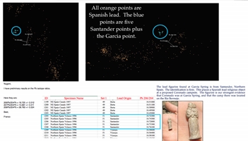
I sent a sample of lead from the figurine to geochemist Franco Marcantonio at the Radiogenic Isotope Geochemistry Laboratory in the Department of Geology and Geophysics at Texas A&M University in College Station. He used Thermal Ionization Mass Spectrometry (TIMS) to measure the Garcia Spring lead figurine isotope ratios as 206Pb/204Pb = 18.725 +/- 0.012; 207Pb/204Pb = 15.681 +/- 0.011; 208Pb/204Pb = 38.763 +/- 0.024. My comparison of these ratios with ratios in my proprietary database of worldwide isotope measurements was conclusive: the figurine’s lead derived from Santander (Cantabria), a region located on the north coast of Spain and mined for lead since Roman times. Four Coronado expedition members are known to have come from Santander: Hernando de Alvarado; don Diego de Guevara; Rodrigo de Ysla; and Juan de Bustamante. Consequently, there were the means, motive, and opportunity for the figurine to have arrived at Garcia Spring with the Coronado expedition in 1540.46
Perhaps the foremost consideration guiding the team’s analysis of the artifacts was who could be excluded as likely carriers of the objects to New Mexico. Difficult to exclude are the most plausible sources for the Garcia Spring iron and lead artifacts: first, the Coronado expedition of 1539–1542; second, the colonists who came to New Mexico with Juan de Ońate y Salazar and began arriving in the río arriba in 1598.47 The Ońate colony increased the distribution and circulation of foreign goods among both colonizers and Indians. Richard Flint describes the setting:
While it is true for areas farther south of Zuni that there was very little Spanish contact following the Coronado expedition, that is not true for Zuni and its environs. Confining ourselves to what is known through documents, two mission churches were established among the Zuni Pueblos in 1629, one at Hawikku and one at Halona. The staffs of those churches included not only priests but lay brothers, servants, and a few soldiers. From that time until at least the late 1700s there was sporadic Spanish presence among the Zunis, primarily religious. . . . García Spring was certainly within what the Zunis considered to be their territory and must have been visited regularly by Zunis. Add to that that Spanish priests were inveterate builders, supplied with materials every two to three years from Mexico, and you have many opportunities for dispersal of such building supplies as nails and spikes, as well as small devotional figurines, both by the priests and by Zunis.Frederick Hodge’s excavation of Hawikku in the 1910s yielded a considerable amount of Spanish metal. That collection has not received significant study. In 1996, Richard Flint, Shirley Cushing Flint, and I received a printout describing over six hundred “Spanish” items from Hawikku and Kechipauan, including at least a hundred nails and spikes; something like fifty iron awls or fragments of iron awls; at least two iron staples; religious medals and crosses; assorted copper items (hooks and eyes, needles, awls, nails); and at least one piece of lead. The printout provides only the most rudimentary descriptions and no photos or measurements.48
Throughout its challenge to suggest a source for the iron, the team considered the metal assemblage at Garcia Spring. Some metals on the site could have arrived with adventurers or military personnel prior to, during, or after the U.S. Civil War. Shell casings are examples of such metal. More certain, however, is that considerable metal arrived with the Antonio Gonzales homestead, patented in 1884. The search of the site produced hundreds of iron remains easily identified as homesteader pieces, dozens of them cast iron like so many of those exhibited in the local museums.
Especially suggestive is that the team recovered only two artifacts of wrought iron. The function of these two pieces, each used in construction, makes adventurers or soldiers unlikely bearers. The conclusion that Gonzales was the source seems natural and is tempting, but it demands an explanation for the rare occurrence of wrought iron on the site and an estimate of the chances that Gonzales had access to that product. Turley doubts that the homesteader forged the pieces but acknowledges that he could have brought them from elsewhere. At the same time, the consistency of the two-wrought iron artifacts with other, similar sixteenth-century pieces means that Coronado cannot be excluded as a bearer of the iron.
The earliest year that the figurine cast from Santander lead could have arrived at Garcia Spring was 1539, with a member of the Marcos de Niza excursion. A Coronado expeditionary could have dropped it in 1540 or 1542. In December 1581, Captain Francisco Sánchez Chamuscado arrived at Zuni, the first Spaniard there since Coronado. The next Spaniard, Antonio de Espejo, reached Hawikku in March 1583, followed in November 1598 by Juan de Ońate. Whether these travelers carried personal Spanish lead figurines remains unknown, so none can be excluded as the source of the Garcia Spring artifact.49
To distinguish between a Spanish lead figurine and raw lead is instructive. The figurine is a personal object and may be many years old. Raw lead is less likely to be a personal item. Four years after Coronado left Hawikku for the last time, silver and lead were discovered in Zacatecas, north of Mexico City. This find caused the development of a road to the mines and beyond, which eventually resulted in the Camino Real. Consequently, all travelers arriving in New Mexico after Coronado followed a different trail. This later route passed directly through the Mexican lead mines, offering an excellent opportunity to obtain raw lead.
Indeed, in 1598 Ońate bought at least 17,168 pounds of lead, all extracted from the Todos Santos mine in Mexico, and transported it to the río arriba of New Mexico.50 Given these circumstances, it is improbable that any raw Spanish lead arrived in New Mexico after the 1546 silver discovery in Zacatecas. On the other hand, a sixteenth-century Spanish traveler carrying a Santander-lead devotional figure seems quite probable, and such a bearer for the figurine cannot be excluded. Nor can the team exclude Franciscan priests posted at the Zuni mission in the 1600s possibly handing out Santander-lead figurines featuring San Cristóbal sent from Spain to Mexico. As the years extended beyond 1539 and 1598, the chance for Spanish lead devotional objects to arrive at Garcia Spring diminished sharply. The 1880s homesteader is essentially excluded as the likely bearer of the figurine. Although the team is unable to identify firmly the carrier of the lead figurine, it is confident that its properties are consistent with sixteenth-century devotionals. Thus, a Coronado expeditionary cannot be excluded as the bearer of the figurine.
The Garcia Spring site has passed the Ewen Test. Our team failed to disprove the hypothesis of Garcia Spring as the Río Bermejo camp. Instead, the team has showed that the historical descriptions in documents produced by Coronado’s men are discernible in the modern setting. The crew recovered multiple utilitarian European artifacts consistent with analogous pieces from the sixteenth-century. Paramount to this project is that we could not exclude Coronado or one of his men as the bearer of the artifacts. Recognizing Ewen, in the absence of another site meeting the same criteria, the team’s findings support Garcia Wash and Garcia Spring as the leading contenders for the Río Bermejo and for Coronado’s camp there.
At the time of this publication, no new exploration for Coronado is underway or planned. Most likely this is the final report on exploration for Coronado’s trail and my last chance to acknowledge all who participated. My adventure with Coronado began in autumn 2004, when I met Richard Flint and Shirley Cushing Flint. Absent the Flints, my Coronado quest would never have happened. Anthropologist Carrol L. Riley introduced me to the Flints, and, later, upon learning of my findings at Kuykendall Ruins, insisted that they be published. To facilitate this result, Cal introduced me to editor Durwood Ball. Without Durwood, my Coronado adventure would never have seen print. Ethnohistorian Bernard L. “Bunny” Fontana was my authority figure; Bunny reassured me that my historical narration of Southwest history did not conflict dramatically with the current understanding.51 These five academics graciously championed my adventure, and I salute them as charter members of the hunt. Fieldwork also created charter members. There is hunting and there is finding. Without finders, no evidence can surface, and no publication is warranted. Ground hunters and charter members who are finders, not just hunters, include Captain Meteor, Loro, Kaspar, and Gordińa.
Without the help of my native guides in St. Johns, this exploration would not have materialized – to Chris, Butch, and Fred a hearty abrazo. To rancher Travis Johnson I send my gratitude for letting us on and for agreeing to let us publish our findings. Blacksmith Frank Turley examined the wrought iron and offered counsel as to its antiquity, leaving me with a firm conclusion. Maritime archaeologist John Bratten provided radiographs of the Garcia Spring pieces and, for comparison purposes, provided similar iron pieces from sixteenth-century artifacts found in Florida. Archaeologist Matt Schmader added Coronado research experience and special counsel. For help with the searches, my thanks go to team member Tyler Brasher and finder Alexa Evans, who recovered the lead figurine from Santander, Spain. Geochemist Dr. Franco Marcantonio, the source for all our isotope measurements, provided the ratios for the lead figurine that revealed its provenience. Rancher Susan Thorn offered oral history and a landscape tour that influenced my prediction of Coronado’s route. Being closest to my heart, imagineer Karen Whiteside Brasher, member of every hunt, is traditionally recognized and always loved.
1My previously published maps are Nugent Brasher, “The Red House Camp and the Captain General: The 2009 Report on the Coronado Expedition Campsite of Chichilticale,” New Mexico Historical Review 84, no. 1 (Winter 2009): map 3, p. 42; Nugent Brasher, “Francisco Vázquez de Coronado at Doubtful Canyon and on the Trail North: The 2011 Report Including Lead Isotopes, Artifact Interpretation, and Camp Description,” New Mexico Historical Review 86, no. 3 (Summer 2011): map 2, p. 342, and map 4, p. 351; Nugent Brasher “The Coronado Exploration Program: A Narrative of the Search for the Captain General,” in The Latest Word from 1540: People, Places, and Portrayals of the Coronado Expedition, ed. Richard Flint and Shirley Cushing Flint (Albuquerque: University of New Mexico Press, 2011), map 9.2, p. 239; and Nugent Brasher, “Exploring for the Coronado Trail: The 2017 Report; A Case Study as a Model for Historians,” New Mexico Historical Review 92, no. 1 (Winter 2017): map 1, p. 31, and map 2, p. 35.
2Reporting expedition members included Capt. Gen. don Francisco Vázquez de Coronado, maestre de campo don García López de Cárdenas, advance party members Juan Jaramillo, Pedro de Ledesma, Juan Troyano, Rodrigo de Frías, and Domingo Martín, and in the following army, Pedro de Castańeda de Nájera.
3“Juan Jaramillo’s Narrative,” doc. 30, in Documents of the Coronado Expedition, 1539–1542: “They Were Not Familiar with His Majesty, nor Did They Wish to be His Subjects”, ed. and trans. Richard Flint and Shirley Cushing Flint (Dallas, Tex.: Southern Methodist University Press, 2005), 513; and “[Francisco] Vázquez de Coronado’s Letter to the Viceroy, August 3, 1540,” doc. 19, in ibid., 256.
4Concerning this specific part of Coronado’s letter, historian Richard Flint and I investigated the original Italian. Flint wrote, “The Italian of the text involved is complex. It includes the use of a double negative: ‘Non si trová quasi niuno Indiano fino á una giornata.’. . . From what I understand, the use of double negatives in Italian is approximately the same as in Spanish. On my very limited understanding of Italian, I think a translation as ‘hardly a single Indian was met for another day’s journey’ would likely have been better [than the published version of 2005, which reads “not a single Indian”]. It is additionally odd that trová is in the present tense, rather than the past (which would be trovó), and furthermore that, if it is present, it should be unaccented.” Richard Flint, email to author, 20 August 2017.
5 “Juan Jaramillo’s Narrative,” doc. 30, in Documents of the Coronado Expedition, ed. and trans. Flint and Cushing Flint, 513. Jaramillo recounted his adventure in his early fifties, some twenty years after the expedition, and confessed that his memory was not always clear. He often used the word habrá (probably). At one point he said, “haver tanto tiempo que aquello pasamos que podria ser enganarme.” Documents of the Coronado Expedition, ed. and trans. Flint and Cushing Flint, 520). My colloquial translation that best captures the sentiment is, “It’s been so long ago that it happened that I could be mistaken.” For a discussion of Jaramillo’s memory, see Documents of the Coronado Expedition, ed. and trans. Flint and Cushing Flint, 509–10. Readers should be mindful that Jaramillo has been my most-trusted trail guide.
6 “The Relación de la Jornada de Cíbola, Pedro de Castańeda de Nájera’s Narrative, 1560s (Copy, 1596),” doc. 28, in Documents of the Coronado Expedition, ed. and trans. Flint and Cushing Flint, 393. Considering the distance in a league, Flint writes that he has “made a thorough and careful study” of the leagues reported by “Castańeda de Nájera and Jaramillo. These two utilize leagues of different lengths: Castańeda de Nájera the legua legal of about 2.6 miles, Jaramillo the legua común of about 3 miles.” Richard Flint to author, 14 July 2014. Further complicating the distance in a league is the handwriting of the document. Castańeda’s “8” leagues could be an error, the true number being a “3”—a common mistake. Castańeda claimed that the first Indians seen by Spaniards were at the Río Bermejo, while Coronado reported that “hardly a single Indian was seen” until the Río Bermejo. I interpret this as meaning that at least one Indian had been seen before the Río Bermejo, and maybe more, and the “first” Indians of Castańeda means the first Cíbola Indians with whom there was any communication.
7 “Eighth de Oficio Witness (Juan Troyano),” in Richard Flint, Great Cruelties Have Been Reported: The 1544 Investigation of the Coronado Expedition (Dallas, Tex.: Southern Methodist University Press, 2002), 166–67, 179–80.
8Several of the Spanish terms used in the expedition documents do not translate well into English, as in this case with laguna having a much wider semantic range than the English term lake. When quoting from expedition documents, I include in brackets the original Spanish word when the English substitute term is lacking.
9“Sworn Statement of the Governor, Francisco Vázquez de Coronado,” in ibid., 279–280, 297–98.
10“Eleventh de Oficio Witness (Pedro de Ledesma),” in ibid., 235–36, 243–45; and “[Francisco] Vázquez de Coronado’s Letter to the Viceroy, August 3, 1540,” doc. 19, in Documents of the Coronado Expedition, ed. and trans. Flint and Cushing Flint, 256. I interpret that Ledesma met the thirty Cíbola Indians at the Bean Patch. Flint defines rreal as an encampment formed of interconnected pavilions, or any major encampment, although occasionally it can also refer to the group that occupies such a camp.
11 “Eighth de Oficio Witness (Juan Troyano),” in Flint, Great Cruelties Have Been Reported, 166–67, 179–80; and “Fourth de Oficio Witness (Domingo Martín),” in ibid., 93–94, 101–02.
12García López de Cárdenas did not testify before the visitador in 1544; his statement was obtained in 1546 in Spain, by which time his name had changed to García Ramírez de Cárdenas. The only account of Cárdenas’s statement of the incidents at the Río Bermejo and Hawikku originally available to me was an English summary published in Narratives of the Coronado Expedition 1540–1542, ed. and trans. George P. Hammond and Agapito Rey (Albuquerque: University of New Mexico Press, 1940), 343–44. Included in Appendix 1 of this report is historian Richard Flint’s transcription and translation of the original Spanish document, La confisión que tomó el licendiado Çianca, 20 February 1546, pieza 1, N. 2, Justicia, 1021, Archivo General de Indias, Seville, Andalusia, Spain. According to Flint, “As for the definition of cerro, Spanish linguist Covarrubias Orozco writes in his 1611 dictionary, ‘tiene varias significaciones. Algunas veces, se toma por la tierra levantada, que ni es valle ni llanura, ni tampoco es tan alta que se puede decir monte.’ [Cerro has several meanings. Sometimes it is understood as elevated land that is neither a valley nor a plain, nor is it tall enough to be called a mountain.]” (Richard Flint email to author 23 July 2014) The common translation is “hill,” but in this instance that translation is inadequate due to the terrain.
13“[Francisco] Vázquez de Coronado’s Letter to the Viceroy, August 3, 1540,” doc. 19, in Documents of the Coronado Expedition, ed. and trans. Flint and Cushing Flint, 256; “Eleventh de Oficio Witness (Pedro de Ledesma),” in Flint, Great Cruelties Have Been Reported, 235, 243; and “Eighth de Oficio Witness (Juan Troyano),” in ibid., 167, 179. For Cárdenas’s testimony, see Appendix 1.
14“Fourth de Oficio Witness (Domingo Martín),” in Flint, Great Cruelties Have Been Reported, 93–94, 101–02; and “Eleventh de Oficio Witness (Pedro de Ledesma),” in ibid., 235–36, 243–45.
15See Cárdenas’s account in Appendix 1.
16“Sworn Statement of the Governor, Francisco Vázquez de Coronado,” in Flint, Great Cruelties Have Been Reported, 297.
17“Definitive Decision of the King and Audiencia,” in ibid., 468; and “The Relación de la Jornada de Cíbola, Pedro de Castańeda de Nájera’s Narrative, 1560s (Copy, 1596),” doc. 28, in Documents of the Coronado Expedition, ed. and trans. Flint and Cushing Flint, 393 .
18See Appendix 1 for Cárdenas account. “Sworn Statement of the Governor, Francisco Vázquez de Coronado,” in Flint, Great Cruelties Have Been Reported, 280; and “Eleventh de Oficio Witness (Pedro de Ledesma),” in ibid., 235.
19“Fourth de Oficio Witness (Domingo Martín),” in ibid., 93.
20“Sworn Statement of the Governor, Francisco Vázquez de Coronado,” in Flint, Great Cruelties Have Been Reported, 280; and “Eleventh de Oficio Witness (Pedro de Ledesma),” in ibid., 236.
21Information concerning the phase of the moon derived from historian Richard Flint: “There would have been no moon visible until about two hours or somewhat less before sunrise.” Richard Flint, email to author, 13 July 2014.
22“Ninth de Oficio Witness (Rodrigo de Frías),” in Flint, Great Cruelties Have Been Reported, 193, 200–201. For my description of the invasion, see Nugent Brasher, “Francisco Vázquez de Coronado at Doubtful Canyon and on the Trail North,” 325.
23For a discussion of leads and prospects, see Nugent Brasher, “Exploring for the Coronado Trail,” 25–27.
24Before selecting the basalt flow as the likely route of Coronado, I also considered Red Hill Draw, LA Draw, Cottonwood Canyon, or Cienega Amarilla. Local guide Susan Thorn lives near the junction of LA Draw, Cottonwood Canyon, and Cienega Amarilla; she guided me around the area. The waterways under consideration are all in canyons with steep sides that offer few places where travelers can climb out, and even fewer where livestock can escape. Had Coronado entered LA Draw via Red Hill Draw, he could not have exited until he reached the conflux of Cienega Amarilla with Carrizo Wash. I considered the basalt plateau route more likely than one through the confining draws. For the army map indicating the Apache trail, see Mallery, Lieutenant J. C. and J. W. Ward, cartographers, New Map of the Territory of Arizona, Southern California and Parts of Nevada, Utah, and Sonora, 1877, 1:1,013,760 scale, 109 × 86 cm, image no. 3327001, David Rumsey Historical Map Collection, http://www.davidrumsey.com/maps5771.html.
25Regarding the Pueblos’ monitoring of the expedition’s approach, Richard Flint recounts: “The day before the 2016 presidential election an 85-year-old man from Laguna Pueblo died. He was one of the keepers of the oral history of the pueblo. I knew him in that role and had talked with him several times about various aspects of the past, as they are remembered at Laguna. As just one example, about the Coronado expedition he once said, ‘We saw them; they didn’t see us.’” Richard Flint email to author, 10 November 2016. Regarding the length of the Coronado expedition’s train, Flint mentioned the following: Alarcón reported that while he was traveling, “[The Indians who had gone to Cíbola said,] ‘One day, before we departed, from sunrise to sunset these Christians did nothing but get themselves there.’ That indicates that it may have taken twelve hours or more for the entire expedition to move past any given point.” Flint adds, “The Italian of that passage is, ‘che un giorno prima che si partissimo non haverano fatto altro dal nascere al tramontare del sole, che arrivare questi christiani.’” Richard Flint, email to author, 20 July 2017. See Alarcon’s narrative of his voyage in Ramusio, Terzo Volume delle Navigationi et Viaggi, 1556, fol. 368v, doc.15, in Documents of the Coronado Expedition, ed. and trans. Flint and Cushing Flint, 201, 218. For a comprehensive discussion of the Pueblos watching the expedition, see Richard Flint, “The Flipside of Discovery: Planned Pueblo Indian Response to the Approach of the Coronado Expedition,” New Mexico Historical Review 88, no. 1 (Winter 2013): 1–14.
26On the northward march from Hardcastle Gap along my proposed route, Carrizo Wash is the first watercourse that could have flowed with bright red water. The red river was located two days from Cíbola. Not on my proposed route is the alternative of Red Hill Draw to LA Draw to Cienega Amarilla to Carrizo Wash. Water in these drainages would likewise have been red. Had Coronado traveled this alternative trail, he would have seen red water long before two days from Cíbola. Regardless of which of these routes he pursued, Coronado would have arrived at Garcia Spring.
27“[Francisco] Vázquez de Coronado’s Letter to the Viceroy, August 3, 1540,” doc. 19, in Documents of the Coronado Expedition, ed. and trans. Flint and Cushing Flint, 256; and “Eighth de Oficio Witness (Juan Troyano),” in Flint, Great Cruelties Have Been Reported, 166–67.
28Respecting the camp at Dangerous Pass, Richard Flint mentioned Vargas Machuca, author of a 1599 book about the practice of warfare. Flint explains: “Vargas Machuca suggests several methods for securing a pass, but he seems most comfortable with having the guard party traverse the pass completely and then occupy a height at its far end (in this case the end farthest toward Hawikku). I don’t get the sense, though, that López de Cárdenas stationed his party on a height—perhaps because horses would not have been of much use there. But he may well have wanted to be at or near the Hawikku end of the pass.” Richard Flint to author, 24 June 2014. For information on Spanish martial tactics commonly employed by expeditions of the sixteenth century, see Bernardo de Vargas Machuca, Milicia y Descripción de las Indias (1599; repr., Madrid, Spain: Librería de Victoriano Suárez, 1892); 180–81. Also available as Bernardo de Vargas Machuca, The Indian Militia and Description of the Indies, ed. and trans. Kris Lane and Timothy F. Johnson (1599; repr., Durham, N.C.: Duke University Press, 2008).
29For travelers between Hawikku and Mexico, see Nugent Brasher, “The Chichilticale Camp of Francisco Vázquez de Coronado: The Search for the Red House,” New Mexico Historical Review 82, no. 4 (Fall 2007): 439.
30“The Relación de la Jornada de Cíbola, Pedro de Castańeda de Nájera’s Narrative, 1560s (Copy, 1596),” doc. 28 in Documents of the Coronado Expedition, ed. and trans. Flint and Cushing Flint, 428. My personal visualization about how the expedition moved is that the travelers were strung out considerably, even by days. Flint stated his impression of Coronado’s train: “When the assembled people of the expedition were at Hawikku for the final time in spring 1542, they would have comprised the largest single group. As may have been true throughout the expedition's travel, it may not have moved as a single mass, but rather as sub-units.” Flint mail to author 25 August 2017. Flint added, “One indication that separate travel was standard practice comes from Francisca de Hozes' 1544 testimony: "when they passed through the [Sonora] valley [in 1540] and proceeded on the conquest and reconnaissance the Indians and towns of the valley came out in peace and gave them supplies from the food they had. But afterwards, when they returned [in 1542], this witness and other persons with don García López de Cárdenas found the town and valley at war. She heard that they had risen up, killed many Spaniards and horses, and fled. The cause of this, she heard, was brutality and outrages committed by a [man named] Alcaraz, [10v] who had been left there as captain by Francisco Vázquez. He, together with other people among those who stayed with him, had seized women and children and committed other outrages and brutality against the Indians. She knows that the Indians killed Alcaraz and many other Spaniards and would have killed don García López de Cárdenas and those who went with him, if they had not turned back and gotten reinforcements from another captain who was coming close behind." Note: the López de Cárdenas group did not just halt and wait for the following group to catch up, but actually "turned back," suggesting that there was some distance between the two parties. Early on, there had been concern about avoiding putting dangerous burdens on local indigenous communities, so that the expedition was to travel in smaller groups by separate routes. There is no reason to imagine that was not their modus operandi. (Email from Richard Flint to author 25 August 2017.)
31While the skirmish at Dangerous Pass likely resulted in the loss of some Spanish metal objects, unfortunately, the event is difficult to locate precisely and may have occurred in the arroyo, in which event the artifacts would be difficult to detect. This prospect must rank below that of the two springs and the lake.
32Camp models are discussed in Nugent Brasher, “The Coronado Exploration Program,” in The Latest Word from 1540, ed. Flint and Cushing Flint, 249–53. See also map 9.2 in ibid., 239.
33Ibid., 249; Nugent Brasher, “The Francisco Vázquez de Coronado Expedition in Tierra Doblada: The 2013 Report on Artifacts and Isotopes of the Minnie Bell Site at Big Dry Creek, Catron County, New Mexico,” New Mexico Historical Review 88, no. 2 (Spring 2013): 209; and Nugent Brasher, “Exploring for the Coronado Trail,” New Mexico Historical Review 92, no. 1 (Winter 2017): n1, p. 46.
34The presence of vantage pueblos guarding the western end of Carrizo Valley emphasizes its strategic location. The valley is the entrada or salida of one of the few passages connecting the Little Colorado and Zuni rivers with Zuni Salt Lake and Hardcastle Gap. Prehistoric human habitation abounds in Carrizo Valley. In addition to pottery sherds, lithic artifacts my team identified at the sites included obsidian darts, jasper projectiles, metates, and manos (grinding stones used in conjunction with metates). Evidence of still older human presence in the area includes Paleoindian projectile points and end scrapers collected by locals at Las Pilas, as well as many archaic sites around the valley. Among pottery sherds identified in Carrizo Valley were Tularosa and Reserve black-on-white, White Mountain Redware, Wingate and Puerco black-on-red, and St. Johns Polychrome. All these pieces dates from 1000–1325. Sherd identification compliments of archaeologist Regge Wiseman. Wiseman to author, 30 October 2014.
35Antonio Gonzales, serial patent, 30 December 1884, Arizona, accession no. AZAZAA 023848, General Land Office Records, Bureau of Land Management, U.S. Department of the Interior [hereafter GLOR, BLM], https://glorecords.blm.gov/details/patent/default.aspx?accession=AZAZAA%20023848&docClass=SER&sid=p2y3yd2a.pry; Juan Salazar, serial patent, 15 September 1891, Arizona, accession no. AZAZAA 023849, GLOR, BLM, https://glorecords.blm.gov/details/patent/default.aspx?accession=AZAZAA%20023849&docClass=SER&sid=x12lnuzc.ksh; José Tapia, serial patent, 21 May 1917, Arizona, accession no. 585480, GLOR, BLM, https://glorecords.blm.gov/details/patent/default.aspx?accession=585480&docClass=SER&sid=bdex3clt.zoq#patentDetailsTabIndex=0; Rosaura Garcia and José Emilio Garcia, serial patent, 6 January 1921, Arizona, accession no. 789260, GLOR, BLM, https://glorecords.blm.gov/details/patent/default.aspx?accession=789260&docClass=SER&sid=ltpemfxh.bbq#patentDetailsTabIndex=0; and Rosaura Gallegos, Rosaura Garcia, and José Emilio Garcia, serial patent, 24 September 1925, Arizona, accession no. 966764, GLOR, BLM, https://glorecords.blm.gov/details/patent/default.aspx?accession=966764&docClass=SER&sid=syorhvxl.csd#patentDetailsTabIndex=0.
36My proposed Coronado camps at Kuykendall Ruins, Doubtful Canyon, and Minnie Bell display these definitive characteristics also. Mallery and Ward, cartographers, New Map of the Territory of Arizona, Southern California and Parts of Nevada, Utah, and Sonora, 1877, image no. 3327001, David Rumsey Historical Map Collection, http://www.davidrumsey.com/maps5771.html.
37Jill Onken to author, 27 June 2017. For a geological evaluation of Carrizo Valley, see Jill Onken, “Late Quaternary Climatic Geomorphology, Volcanism, and Geoarchaeology of Carrizo Wash, Little Colorado River Headwaters, USA” (Ph.D. diss., University of Arizona, Tucson, 2015), 121–22, 196–97, table 4, on p. 233, fig. 3, on p. 243, fig 4, on p. 244, fig 6, on p. 246. A reasonable model for extinct Garcia Wash is Onken’s stratigraphic column at McKinley Tank, located south of Zuni Salt Lake in the Carrizo Wash drainage basin. On the model, Garcia Wash is represented as Stratigraphic Unit 7. These sediments represent the filling of a channel that was once ninety meters wide and seven meters deep. At a depth of approximately three meters below the modern surface of this extinct arroyo are vegetal remains dated at 550 years old, the year 1467, some seventy-three years before the arrival of the Coronado Expedition in 1540. Other exposures of Stratigraphic Unit 7 provide even younger dates, showing that the arroyo continued to fill another three meters. Today the channel is slight at best.
38Onken, “Late Quaternary Climatic Geomorphology,” 121–22. For maps showing roads in Carrizo Valley, see Mallery and Ward, cartographers, New Map of the Territory of Arizona, Southern California and Parts of Nevada, Utah, and Sonora, 1877, image no. 3327001, David Rumsey Historical Map Collection, http://www.davidrumsey.com/maps5771.html; and U.S. General Land Office, Territory of Arizona, 1896, 52 × 43 cm, image no. 3773001, David Rumsey Historical Map Collection, https://www.davidrumsey.com/luna/servlet/detail/RUMSEY~8~1~223680~5506242:Territory-of-Arizona,-1896.
39K. C. Anderson and J. S. Edwards, “Holocene geomorphic history and geoarchaeology of Carrizo Wash,” in Archaeological Excavations in the Carrizo Wash Valley, East-central Arizona: Data Recovery on the Fence Lake Mine Transportation Corridor, Cultural Resources Report No. 03–265, ed. D. Gilpin, et al (Flagstaff, Ariz.: SWCA Environmental Consultants, 2004), 607–634.
40Jaramillo and Castańeda reported different numbers of Cíbola Indians first seen at the Río Bermejo. Jaramillo recalled three, Castańeda two. I have accepted Jaramillo’s memory. “Juan Jaramillo’s Narrative,” doc. 30, in Documents of the Coronado Expedition, ed. and trans. Flint and Cushing Flint, 513; “The Relación de la Jornada de Cíbola, Pedro de Castańeda de Nájera’s Narrative, 1560s (Copy, 1596),” doc. 28 in ibid., 393.
41For a discussion of the Ewen Test, see Nugent Brasher, “The Red House Camp and the Captain General,” 53.
42Frank Turley to author, 18 June 2017.
43Frank Turley to author, 26 June 2017; Frank Turley to author, 18 June 2017; and John Bratten, email to author, 25 September 2017. Specific to the Garcia nail, Turley wrote on 26 June 2017: “I doubt that the nail was made by a homesteader. If it was, you would have probably found evidence of a smithy on site. It would have shown itself by a charcoal or coal surround with various cut and waste ferrous pieces lying around, and maybe a tool or two. In the 1880’s, a homesteader could jury-rig a little charcoal fire and with a hand bellows, make a wrought iron nail, but doubtful.”
44Brasher, “Francisco Vázquez de Coronado at Doubtful Canyon and on the Trail North,” 335–38; and Bonnie G. McEwan, “Spanish Precedents and Domestic Life at Puerto Real: The Archaeology of Two Spanish Homesites,” in Puerto Real: The Archaeology of a Sixteenth-Century Spanish Town in Hispaniola, ed. Kathleen Deagan (Gainesville: University Press of Florida, 1995), 220. For photographs of nail types, see http://chichilticale.com/travels.htm.
45“Cristobal, con largas vestiduras ceńidas a la cintura por un cinto, lleva en sus brazos, y a veces ante su corazón, a Cristo en Magestad. . . . Cristóbal es por regla un gigante; el nińo aparece. . . desnudo a menudo, extiende la mano. . . sostiene el globo terráqueo.” Gaston Duchet-Suchaux and Michel Pastoureau, Guía Iconográfica de la Biblia y los Santos, trans. César Vidal Manzanares (Madrid, Spain: Alianza Editorial, 2009), 142–43.
46For the original data for Santander isotopes, see F. Velasco, A. Pesquera, and J. M. Herrero, “Lead Isotope Study of Zn-Pb Ore Deposits Associated with the Basque-Cantabrian Basin and Paleozoic Basement, Northern Spain,” Mineralium Deposita 31, no. 1–2 (1996): 84–92. For Roman mines in Santander, see Lino Montecón Callejo, “La Minería Romana en Cantabria,” Nivel Cero 8 (2000): 37–58, https://revistanivelcero.files.wordpress.com/2012/08/nc8_03.pdf. Names of Coronando expedition members from Santander provided by historians Richard Flint and Shirley Cushing Flint. Flint and Cushing Flint, email to author, 28 July 2018.
47Between the departure of Coronado in 1542 and the arrival of Ońate in 1598, two parties reached Zuni and Hawikku. The first, led by Captain Francisco Sánchez Chamuscado, arrived in December 1581. The second, led by Antonio de Espejo, arrived in March 1583. The size of both parties and the lengths of their stays lead me to consider them less plausible bearers of the artifacts, although I do not exclude the possibility. For both expeditions, see George P. Hammond and Agapito Rey, he Rediscovery of New Mexico, 1580–1594: The Explorations of Chamuscado, Espejo, Castańo de Sosa, Morlete, and Leyva de Bonilla and Humańa (Albuquerque: University of New Mexico Press, 1966).
48Richard Flint to author, 2 June 2017.
49Brasher, “Francisco Vázquez de Coronado at Doubtful Canyon and on the Trail North,” 347–55.
50Ibid., 357.
51Ethnohistorian Bernard L. “Bunny” Fontana died on 2 April 2016 at age eighty-five. About a year later, anthropologist Carrol L. Riley died the morning of 25 March 2017 at age niney-three. With the deaths of Cal and Bunny, two of my closest advisors and supporters have passed on. I miss them both.
AGI, Justicia, 1021, N.2, pieza 1, excerpt (question 6)
la confisión que le tomó a García Ramírez de Cárdenas
transcription
Richard Flint
[photo 1865]
[...]
{cuenta al / paso desde / cuyuacan / a (s)ci(v)bola} {ytem} Preguntado que diga e declare las entradas E RenCuentros en que este Con- / Fesante [Ramírez de Cárdenas] se hallo desde que fue proVeido por maestre de canpo / hasta que de(x)jo de serlo. di(x)jo que dende la dicha proVincia de Cu- / yuacan el dicho francisco Vazquez entro en demanda de Çibola con / sesenta de caballo poco(s) mas o menos E la demas gente de(x)jo / en la dicha proVinçia e a don tristan de arellano Con ella e que / este confesante fue Uno de ellos que fueron con el dicho francisco / Vazquez hasta la proVinçia de Çibola e hasta llegar tres / o quatro leguas de la dicha Çibola no hubieron RenCuentro / nynguno con yndios E que llegados ally este que depone yba de- / lante con ocho or diez de caballo E Vio Çiertos yndios subi- / dos en Un ceRo E se adelanto solo este ConFesante hasta donde /estaban los dichos yndios ha(z)ciendoles seńas de paz E RegaloSe
[photo 1866] dandoles de los Rescates que lleVaba E con esto ba(x)jaron algunoS / de los dichos yndios E tomaron los Rescates que este Confesan- / te les daba E les dio las manos E estuVo de paz con los dichos yn- / dios E les dio Una cruz e les di(x)jo por seńas / que fuesen al pueblo E di(x)jesen a los que en el estaban que Venyan / de paz e que queryan ser sus amigos E que con esto se fue- / ron los dichos yndios al pueblo y este conFesante se quedo / ally aguardando al dicho Francisco Vazquez E a los demas que con el / Venyan E que en el m(e)ismo lugar donde hallo los yndios hi(z)cie- / ron noche esperando los dichos yndios E que este confesante / con Çierta gente se puso a guardar Un mal paso que habia por- / que si los yndios V(e)inyesen de gueRa no les ofendiesen2 E / a la media noche dieron en este conFesante E en los que con el / estaban en el dicho paso mu(n)cha copia de yndios E de los gritos a- / Vezes E Flechas que los dichos yndios tiraban se espantaron / los caballos que este confesante e los otros tenyan e se huyeron / E quedaron a pie E que syno Fuera por dos de a Caballo que / Tenian por çentinela e guarda matar(o)an a este ConFesante / E a diez conpańeros que con el estaban guardando el dicho / paso E que otro dia por la mańana llego francisco Vazquez / con la demas gente E sabido lo que aquella noche habia aCa- / e(s)çido desde ally todos juntos en orden camynaron ha(z)cia Çibola / E a obra de [at about] Una legua antes que llegasen a Çibola Vieron qua- / tro o çinco yndios E en Viendolos torno a parar la gente / E este confesante se adelanto de la otra gente Solo a ha- / blar con los dichos yndios ha(z)ciendoles seńas e muestras de / paz E que no le aguardaron E que visto esto en la mysma or- / den que yban camynaron hasta llegar çerca de Çibola adon- / de hallaron toda la gente de yndios de Çibola e de otroS lu-
[photo 1867] gares que se habian juntado puestos en armas esperandolos.3 E que / Visto eSto eSte que depone E Un fray LuiS de la orden de San Francisco E Un / escri(v)bano que SerVia de Secretario al dicho Francisco Vazquez Se adelantaron / de la oTra gente E llegaron çerca de donde los dichoS yndioS / eSTaban (h)alargando los E moStrando las Seńales de paz4 E / d(a)e(x)jaron las armas Para que VinyeSen a ellos E que loS dichoS / yndios Ta(n)mbien laS de(x)jasen E que los dichos yndios no lo quisye- / ron ha(z)cer anteS Se Venyan ha(z)cia eSte Confesante E el dicho frayle / E Secretario5 Tirandoles mu(n)chas flechas. E (^h??) dieron al frayle / Un Flechazo en los habiTos E al dicho escri(v)bano oTro en los VeStidos / E armas E ViSTo eSto por el dicho francisco Vazquez llego Con Toda / la demaS gente que con el eSTaba llego a favore(s)çer a eSte Con- / Fesante E que a(n)Si llegado anteS que RompieSen con loS dichoS / {requieren de / paz a los indios} yndios el dicho Francisco Vazquez Torno a Requeryr de Paz a loS. / dichoS yndios E que no lo quySieron ha(z)cer E que el dicho Francisco Vaz- / quez mando que Ro(n)mpieSen con ellos Porque los dichoS yn- / dios Se Volvian a los dichos esPańoles en los amableS de paz.6 / E que de aquel Ro(n)mPimyento maTaron algunos yndioS / E que oTros se metieron en el pueblo de çibola7 e(^a)n el(a) pa- / re(S)çer de eSTe ConfeSante no Fueron aRiba de diez o do(z)ce / {diez o do(z)ce / indios despues /del requ(i)erimyento} los que muryeron de los dichoS yndios. E que despues de meti- / dos en el pueblo los dichos yndios el dicho Francisco Vazquez los torno a / Requeryr de paz y eSTando en esTo llego fray marCoS de / nyça Frayle Franciscano que (h)era el que guyaba el dicho E(x)jerçiTo eSpa- / ńoL E francisco Vazquez le dio quenta de todo lo que haBia paSado E oydo poR / el dicho Frayle E Visto como los yndios eSTaban enCaSTilladoS / di(x)jo el dicho Frayle Tomen RodelaS E Vayan a ellos E a(n)sy el dicho / Francisco Vazquez E Algunos de los que con el estaban lo hi(z)cieron / E fueron a los dichos yndios E al enTrar del pueblo de Çibola die- / ron al dicho Francisco Vazquez dos o Tres pedradas que le deRibaron
[photo 1868] en el Suelo E que syno le soCoRieran eSte Confesante E oTroS que / con el eSTaban le maTaran E con el mal herido Se ReTiraron E deS- / Pues de esTo los yndios por seńas di(x)jeron a eSte que declara que / no les hi(z)ciesen mal porque ellos se queryan salyr del pueblo E que / eSte que declara les di(x)jo a los dichos yndios que si se queryan eSTar que / {y se fueron aUnque / les di(x)jo que Se esTu- / viesen} Se eSt(o)uViesen E que Todos eStarian de paz E que no quysieron / syno yrse E que a(n)si se fueron syn que se les hi(z)cieSe mal por / los dichos espańoleS E les de(x)jaron a los dichos (^ch) espańoles el dicho pueblo / de Çibola Solo E se enTraron E aposenTaron E eSt(o)uVieron en el haSta / dos o Tres meses poco mas o menos todos los dichos espańoles / [...]
Notes
1. 1535.
2. Majascule S[usodicho] and F[rancisco] in this line look identical.
3. Hammond and Rey, Narratives of the Coronado Expedition, 344, in their translation ignored the verb ofender. Instead, they gratuitously added "the Spaniards would not let them pass." DRAE, 1565: "ofender...3. [archaic] Hacer dańo a alguien fisicamente, hiriendolo o maltratándolo."
4. Rather than describing the Pueblo people as armed and simply awaiting the expedition, as the verb esperar indicates, Hammond and Rey, Narratives of the Coronado Expedition, 344, embellished the passage, writing instead, "who had gathered to meet them with force."
5. Again Hammond and Rey, Narratives of the Coronado Expedition, 344, embellished the Spanish text by adding the words "they coaxed them," which have no correlate in the Spanish.
6. Although López de Cárdenas, as recorded by the scribe, used the very dispassionate words "se venían hacia/they were approaching," Hammond and Rey, Narratives of the Coronado Expedition, 344, added drama to the passage by using this "translation": "they rushed toward
7. This passage is made very difficult to translate because of its non-standard orthography and spelling, combined with the scribe's frequent use of virgules/dividing lines of various shapes within the text. Hammond and Rey, Narratives of the Coronado Expedition, 345, translated the passage very differently than we do: "Then Francisco Vázquez ordered that they be attacked because the said Indians rejected their offers of peace" (emphasis added). Because Hammond and Rey did not also publish their transcription of the Spanish original, we cannot guess how they came to the peculiar translation they did.
The actual Spanish reads:

Hammond and Rey appear to have ignored several words in the passage (se volvieron and los amables in particular) and a virgule between "los" and "amables." In the end, they seem simply to have stated what they thought, incorrectly, was the gist of the passage, without tying it strictly to the Spanish text.
8. Again we differ significantly with Hammond and Rey. They translated "se metieron" as "fled to" the pueblo, whereas the Spanish does not imply rushed and fearful entry into the pueblo. In fact, "se metieron" provides a decidedly neutral and emotionally non-specific account. In comparison, Vázquez de Coronado, describing the same event to the viceroy, as translated into Italian (Flint and Flint, Documents, 257), characterized the Indians' return to the pueblo as accomplished with haste and panic: "some of them fled [fuggirono] quickly [subito] to the ciudad." This suggests that Hammond and Rey may have made an effort to assure that their translations of the various expeditionary accounts were consistent with each other and reflected the same observational and rhetorical perspectives. On the contrary, though, López de Cárdenas and Vázquez de Coronado had very different purposes and perspectives in writing their separate accounts.
AGI, Justicia, 1021, N.2, pieza 1
The Sworn Statement of the Accused, García López de Cárdenas
His Response to the Sixth Question Posed by licenciado Andrés Cianca of the Consejo de las Indias
Pinto, February 19, 1546
translation
Richard Flint
September 2017
[photo 1865]
[...]
{He tells about the segment of the journey from Culiacían to Cíbola}
The accused was asked to state and declare, under the obligation of the oath that he has made, what incursions and engagements [rencuentros] he was involved in from [the time] he was appointed maestre de campo until he stopped serving as such.
He stated that from the aforesaid province of Culiacán Francisco Vázquez [de Coronado] entered [the previously unreconnoitered land] in search of Cíbola with sixty horsemen, or a little more or a little fewer. He left the rest of the people in the aforesaid province [of Culiacán] along with don Tristán de Arellano. The accused was one of those who went with Francisco Vázquez until [they reached] the province of Cíbola. Until they arrived three or four leagues from [the pueblo of] Cíbola they did not have a single engagement [rencuentro] with Indians.
When they had arrived [at that point] the declarant went ahead with eight or ten horsemen. He saw a few Indians who had ascended a hill. The accused went forward alone as far as where the aforementioned Indians were, making signs of peace to them and giving them gifts, [photo 1866] giving them things from among the trade goods he was carrying. As a result, some of the Indians came down and took the trade goods that the accused was presenting to them, and he extended his hands to them. He was with those Indians peacefully and gave them a cross. He told them by means of signs to go to their pueblo and tell those who were in it that [the expeditionaries] were coming in peace and wanted to be their friends. With this, the Indians went away to their pueblo.
The accused remained there awaiting Francisco Vázquez and the rest who were coming with him. In the same place where he found the Indians they spent the night, waiting for the aforementioned Indians. The accused, with a few people, was stationed to guard a bad pass that there was, so that if the Indians came to make war, they [the expeditionaries] would not be harmed.
At midnight a large number of Indians attacked the accused and those who were there with him. With the occasional shrieks and arrows that the Indians fired, the horses that the accused and the others had were spooked and ran off. [The men] were left on foot, and if it had not been for two horsemen whom they had as sentinels and guards, [the Indians] would have killed the accused and the ten companions who were with him guarding the aforesaid pass.
The next day in the morning Francisco Vázquez arrived with the rest of the people. When he learned what had occurred that night, everyone together traveled in order toward [the pueblo of] Cíbola. About a league before reaching Cíbola they saw four or five Indians. When they saw them [the Indians], the people stopped again, and the accused went on ahead of the other people alone to talk with the aforementioned Indians, making signs and demonstrations of peace to them.
[But] they [the Indians] did not wait for him. When this was seen, [the expeditionaries] traveled on in the same order in which they had been traveling, until they arrived near [the pueblo of] Cíbola. There they found all the Indian people of Cíbola and other places [photo 1867] who had come together, bearing their arms and war gear, waiting for them.
When this was seen, this declarant and one fray Luis of the Order of San Francisco, as well as a scribe who was serving as secretary to Francisco Vázquez, went ahead of the other people. They arrived near where the Indians were, advancing toward them and showing them signs of peace. [The expeditionaries] lay down their arms, in order to approch them [the Indians]. And the Indians were also to lay down theirs. [But] the Indians refused to do that; rather, they were approaching the accused and the aforementioned friar and secretary.
[The Indians] were shooting many arrows and struck the friar in the habit, and also the secretary in his clothing and armor. When this was understood by Francisco Vázquez, he came with all the rest of the people [expeditionaries] who were with him. He came to help the accused, and when he had arrived in this way, before [the expeditionaries] might attack [the Indians] Francisco Vázquez once again delivered the requerimiento [summons to peace] to them [the Indians].
{They deliver the requerimiento to the Indians.}
Because they refused to do that [submit], Francisco Vázquez ordered that [the expeditionaries] attack them [the Indians]. The Indians were turned by the Spaniards into lovers of peace because in that attack they killed some Indians while others got into the pueblo of Cíbola. In the opinion of this declarant, those of the aforementioned Indians who were killed were no more than ten or twelve.
{Ten or twelve Indians [killed] after [delivery of] the requerimiento.}
After those Indians had entered the pueblo, Francisco Vázquez once again delivered the requerimiento to them. At this point, the Franciscan friar who was the one guiding the Spanish force, fray Marcos de Niza, arrived. Francisco Vázquez gave him an account of everything that had transpired. When that had been heard by the friar and he had seen that the Indians were fortified, the aforesaid friar said to take up their shields and attack them [the Indians]. Thus, Francisco Vázquez and some of those who were with him did so and attacked the Indians.
When he entered the pueblo of Cíbola, [the Indians] gave Francisco Vázquez two or three blows from thrown rocks, which knocked him [photo 1868] to the ground. If the accused and others who were with him had not gone to his [the captain general's] aid, [the Indians] would have killed him. And they withdrew with him [Vázquez de Coronado] severely wounded.
After this the Indians communicated through signs to the individual who is making this declaration that they [the expeditionaries] were not to do them harm, since [the indians] wanted to leave the pueblo. The declarant told those Indians that if they wanted to stay [there] they were to remain and that everyone would be at peace. But they did not want anything except to depart. Thus, they went away without being done any harm by the Spaniards. And [the Indians] left the pueblo of Cíbola to the Spaniards alone. They, [in turn,] entered [the pueblo] and lodged there. All the Spaniards were there for up to two or three months, or a little more or less.
