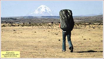
Exploring for the Coronado Trail
The 2017 Report —A Case Study as a Model for Historians
Historians enjoy a story opened with a grabber, a spike of temptation readers cannot escape. Avoiding emotion, geologists and archaeologists prefer to open their stories with an abstract, that is, a synopsis of what is contained therein. Investors are accustomed to reading an executive summary preceding the support documents. While respecting all of these gambits, I am most hopeful that this story opens with promise.
The telling that follows is about a search process employed to find a legendary and long-sought route, the Coronado Trail. A geologist, that’s me, is the storyteller, as well as the searcher. My narrative begins at the time I left the university in 1969 and entered the geological workforce. Upon arrival at the office, my masters began to train me in hopes that I would become an exploration geologist. The first bit of this tale is about that learning experience. Then the story skips forward some thirty to forty years to a case study of how I applied geological exploration methods and philosophy for purposes of historical sleuthing. The process is the story.
Exploration is original research. My previous publications were exploration reports containing original research data and information. This report, on the other hand, is not a presentation of original research material but rather a description of the method and process that I used to explore the sixteenth-century trail of Capt. Gen. Francisco Vázquez de Coronado. i
The methodology I employed was basic, experiential, and instinctual. Exploration must be innovative and flexible, so I customized traditional exploration fundamentals for application to a specific search for Coronado. Customization was essential because there is no such thing as an orthodox exploration approach. Each exploration is singular and dynamic, with the ending impossible to know beforehand.
In the late 1960s, I began my professional career as an exploration geologist working in an office with five experienced explorers. These masters trained me to examine and interpret original (primary) source documents in order to create a custom map predicting where undiscovered oil fields were hiding, to write a report supporting my claims, and to make a formal presentation of my reasoning and conclusions before my colleagues. One of my trainers tagged exploration as a form of detective work, asserting that clues resided in the documents, and if these clues were correctly interpreted, a fruitful map could be drawn. ii
The original source documents I examined for geological exploration were records pertaining to individual wells in a defined area. Data from those historical wells were the sources for extracting clues useful for locating undiscovered oil fields. Historians might think of such original source documents as primary historical records for a singular event that is only one of many in a larger event—such as the records pertaining to an individual battle site of the American Civil War residing in a database of all known battles—with the hope of mining the database to locate undiscovered battle sites.
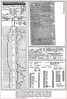
Original source documents initially consulted for regional exploration by oil geologists in the late 1960s included electric logs and sample logs, each of which were graphical, not textual. Also included were scout tickets and driller’s logs. Some of these tickets and logs were typewritten but most were handwritten by the recorder, who wrote in abbreviations using the slang and jargon of oil scouts and drillers (fig. 1). These documents were provided by people or instruments closely associated with a particular well at the time of the drilling; the recorders—human or mechanical—were likely present on the drill site. While these documents represented the major portion of the official account and were required to be filed with public regulatory agencies, they did not represent all the original source documents. Some documents did not require public release and were retained by exploration and production companies for competitive reasons, making them more difficult to retrieve.
Documents containing data elements extracted from these original sources and presented again were always considered secondary source documents. While scouts and drillers sometimes recorded errors in original documents, copiers and encoders generating secondary documents introduced most mistakes or inaccuracies. Additional complications were created by a copier’s routine of reporting only selected bits of data rather than all the data, a practice that left secondary documents incomplete. Furthermore, secondary documents often contained annotations. My trainers took care to remind me that I was to present my own interpretation and that outside annotations should be avoided during the primary stage of exploration.
Experience taught that some geological documents were dangerous regardless of the source. Some original documents were totally and absolutely incorrect; their only service was to fool the unknowing, a purpose for which certain ones were clearly and intentionally designed. Still other documents were mostly correct, but contained subtle errors that would plague interpreters.
Historians likewise have access to original and secondary source documents. From my point of view, the handwritten testimony of a traveler from 1540 to a scribe is an original source document, but a subsequently transcribed, translated, annotated, and published interpretation of that testimony is a secondary document.
Exploration geologists discriminate between original and secondary documents, choosing the appropriate time to consult secondary sources. The intent is to compile a database by following the adage that “accuracy trumps completeness,” that is, missing data is less problematic than incorrect data. Because I solely employed original source documents, as a geologist, I could read and interpret the records only by learning the language and the signs. Consequently, my exploration was founded on reading and interpreting original geological source documents in their specialized language, not a translation or transcription, and by providing my own personal annotations. iii
My trainers considered the original source documents to be a narrative best understood when they are read in chronological order as written. Examining source documents in such sequence provides a perspective to understand what was known at a specific time and to observe what action was taken on that knowledge. A chronological reading enables the explorer to watch the event evolve. This is a version of “who knew what, when did they know it, and what did they do?” Such a snapshot may provide clues to motive for a specific action and helps answer the question of “why did they do that?” This method reveals the historical search patterns, showing wrong turns, and right ones, too, and provides explanations based on what was known at the time as opposed to what was known subsequently.
Because of the competitive milieu of oil exploration, the initial dataset obtained by oil explorers was normally nearly complete. By law, the release of such data was required, after a short delay. Libraries and commercial outlets subsequently retrieved, archived, and organized the released data, making the records easily available, for a price, to competing geologists. This luxurious convenience is not normally enjoyed by historical investigators, who must search through volumes of material, sometimes not knowing exactly what they are seeking, often being surprised by what they uncover, never knowing if they found all the relevant data, and fearing that they have missed valuable sources. My search for Coronado was facilitated by Richard Flint’s and Shirley Cushing Flint’s collection of documents and their sorting of them by date written. This favorable state of affairs provided me the means to read a complete set of Coronado-related documents in chronological order. I now appreciate this circumstance as an anomaly in historical sleuthing.
After gathering the initial dataset and organizing it into the preferred order, such as from earliest date to the last, the geologist began his inquiry by reading and interpreting the source documents, while keeping a journal to mark his trail of investigation. Of foremost importance was to employ the art of pattern recognition to compare well logs to one another in order to obtain measurements of elevations and thicknesses of strata. These measurements were then used in geological mapping to reconstruct the ancient landscape. Multiple maps were required; some showed topography at a given time, others showed thickness of geological strata, and still others showed the type of rock present. The maps were custom created by the individual geologist; they were unique maps that had never before been drawn. Geology, petroleum science, and dates comprised most of the data elements needed for regional oil and gas exploration mapping. The end result was a set of graphics illustrating the geologist’s prediction of locations where oil fields likely lay hidden. These locations became “areas of interest,” or “leads.”
Not all leads were equal. Some were reveled as potential monetary giants, some enjoyed more supporting evidence than others, and some were crippled by issues that would restrict further investigation of the lead. Most sought by interested parties were leads that might locate oil fields large in size and rich in production. Such fields were tagged “elephants.” Indeed, the exploration manager had selected the study area because of its potential for elephants, by so doing enforcing the prerequisite that potential fields to be discovered must be worthy of the search for them in the first place. Elephant territory was described as having “romance,” an essential quality for any exploration target because romance emotionally bonds the explorer to the adventure.
The geologist ranked the leads from most to least potential for discovering a productive source of oil or gas. Then each lead was examined meticulously after acquiring supplementary original source documents pertinent to a specific examination and after consulting, for the first time, secondary documents to the dataset. Geologists exercised caution while considering secondary documents, demanding that their authors demonstrate an indisputable foundation for their opinions. To gain a general view of specific and known oil fields, geologists could consult books and reports describing and illustrating typical fields. Lead examination often prompted geoscientists and engineers to develop new means of investigating available and existing data. In the process, they exposed by new technology those clues preserved in archival records, but not previously recognized, and by so doing weakened or strengthened a lead.
Comparison of a predicted oil field, that is, the lead, to an extant oil field, is always instructive. This practice is akin to a historian consulting reports and maps of individual forts in a region containing multiple forts, some similar to others but not all the same. The historian might desire to know the typical look of a fort or the range in fort appearance, perhaps in hopes of predicting where an undiscovered post might be hiding or of reclassifying one already extant. In the same way, an archaeologist compares artifacts from developing sites to pieces from established sites, using “look-alike” as one of the attributes to consider for purposes of identification.
Paramount in exploration is reducing the risk of failure. The geologist commences this process by exercising extreme care with initial data interpretation and mapping. After identifying multiple leads through regional mapping, the geologist, who represents the principal proponent of a set of leads and knows the most about them, then pursues individual leads with the intention of discrediting them. In the jargon of oil and gas exploration, he tries to “kill” a lead. All leads are purposely pursued to exhaustion, leaving nothing uninvestigated, the result being death or survival. iv
Death of a lead can result from technical reasons such as erroneous data or ambiguous interpretation. Death can also be caused by nontechnical issues such as not enough return on the investment or concerns about operating conditions. Leads are commonly killed as a consequence of knowing that a particular landowner is unwilling to allow exploration or willing to permit it only at an extravagant price. Exclusion of failed leads is a means of elevating the survivors in order to devote financial and technical resources to the most-attractive opportunities.
As examination of data proceeds, some leads cannot be killed and therefore are advanced to “prospect” status, meaning that expensive original source data will be obtained in hopes of discovering an oil field. In the fortunate event that the prospects are arranged in a pattern and display a likeness to one another, the prospects can be grouped to create a “play.” Plays are attractive because they reduce risk by providing multiple opportunities for success. Additionally, since the prospects are similar, procedures and logistics can be standardized and optimized. Procedures can be modified as development progresses, further reducing risk and expenditure, and concomitantly increasing the probability of success. What is learned on any one prospect can be applied to the other prospects in a play.
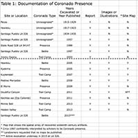
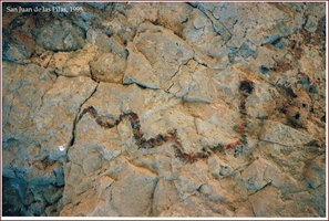
One valuable ingredient in oil exploration is the study of existing oil fields. Metaphorically for this discussion, Coronado campsites, battle sites, and occupation sites are equivalent to oil fields. Exploration for Coronado by study of such sites, however, was not possible in 2004 because no sites had been adequately mapped. As of October of that year, the published Coronado dataset pertaining to specific sites included only photographs and sketches of artifacts found at the Jimmy Owens site in Texas and at the LA 54147 and LA 326 sites in New Mexico (see table 1). All three were considered bona fide Coronado presence, but none had been mapped to show the size, shape, or arrangement of the expedition’s presence. Most conspicuous by its absence from the 2004 dataset was any relevant description of the showcase Jimmy Owens site discovered in 1995 and studied until 2008. This unfortunate omission from the published historical record continues at the time of this writing, effectively denying researchers the results of thirteen years of university study of the sole accepted Coronado site.v
Continuing to apply the analogy of Coronado presence and oil fields, I injected the reality that, more commonly than might be expected, drillers fail to recognize a successful find—they bore through the oil zone without detecting it, or they assign an incorrect identity to it, thereby diminishing its true importance. This significant blunder is tagged “drilling through the pay and not seeing it.” Recognition of the target when it is encountered is mandatory for successful exploration. So, I wondered whether signs of the Coronado expedition had been found in the past and not realized. vi
To continue oil exploration after prospect identification requires contact with the landowner to secure authorization to drill on his land. This requirement is called “getting a lease” and is paramount to success; without a lease, no exploration can proceed, and the prospect is doomed to failure. While historical exploration demands the same process for a physical landscape, the historian is often confronted additionally with gaining permission, or “getting a lease,” just to see documents or artifacts in collections held by individuals or private institutions.
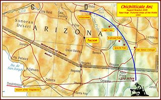
Exploration is a hunt. The quarry, or target of the hunt, must be worthy of the endeavor. The famous Coronado offers romance and is the equal of an oil elephant, thus satisfying those requisites. One morning in September 2004, the Flints recounted to me bits of the colorful history of the long hunt for the trail of the captain general, and for the first time, I heard the names Winship and Chichilticale. After listening to the Flints, I assessed the Coronado saga as a worthy but immature play, an exploration opportunity that despite over a century of scholarly work, had yielded only scant data, while at the same time, it presented multiple chances for discovery of a laudable prize. Most of all, the hunt for Coronado offered the thrill of a romantic search.
Curious and compelling to me was that the original source documents essential to chase Coronado were not feasibly available to an explorer in 2004. The Flints’ authoritative tome containing the gathered and transcribed documents would not be on shelves until summer of the next year. Given that the Flints had offered me advance copies of the transcriptions, I enjoyed the competitive advantage of being first to hold their valuable dataset. As Richard Flint would write eleven years after the fact, “And of course in your case it was the Spanish transcriptions that you needed, almost none of which had previously been published [before 2005].” In geological experience, this rare and prized opportunity was equivalent to being the first and only explorer in the private data room. vii
The play offered challenges. It was a search for presumed campsites along an undetermined trail. No campsites had been described and few artifacts had been found and correlated with the expedition. Romance, however, mitigated those inconveniences, and I could not resist the temptation. In October 2004, at age sixty, I received from the Flints the Microsoft Word files that had been used to create their forthcoming book of transcribed original source documents. With these in hand, I began my committed quest to find the trail and traces of Coronado. viii
The Coronado exploration program is a multidisciplinary effort. Contributors include geologists, engineers, historians, archaeologists, anthropologists, chemists, metallurgists, numismatists, museum curators, blacksmiths, artists, jewelers, statisticians, ranchers, art historians, collectors, and librarians. I have consulted these and other specialists for better understanding of the subject under examination. My exploration program includes original research, innovative technology, laboratory and fieldwork, library and museum research, primary interviews, and examination of private collections. The financial strength to support that, of course, was required and accepted. ix
Dawdling to conclusions can be more deleterious to exploration than rushing to them. Exploration is best conducted by total immersion in the program by an explorer who is curious, goal-driven, creative, steady, tenacious, and willing to kill leads. Such an explorer will seek action on his inspiration by relentlessly pursuing a process to get his ideas tested. The plan of operation should be to focus entirely on the program until the team reaches a working conclusion. In the case of the Coronado exploration program, the working conclusion was to be the result of having completed an initial study of the original source documents, having traveled over the probable expedition landscape, and having marked on an exploration map at least one predicted route for the Coronado expedition. I described that goal: “To identify each individual Coronado camp was not my first objective. To my mind, most important was to identify the locations of major events or landmarks affecting the route so as to suggest a travel corridor. Once the corridor was identified, specific locations, such as campsites, would become apparent.”x The goal was achieved after three months of intensive, immersed study.
One of my work products was a custom map generated from the New Mexico Archaeological Records Management Section (ARMS) database. I first examined the database to determine which data elements were available and to learn how they were coded. I then wrote an algorithm that would generate custom codes useful for displaying site locations as types of human presence. Using my algorithm, a custom extraction was subsequently provided me by Karyn de Dufour of ARMS. Creating files from the extract she provided, I used my personal software to create an exploration map reproduced herein as map 1.xi
As with my geological exploration, I read original source documents available to me, these being the fourteen transcriptions provided me by the Flints. I purposely avoided all published interpretations and analyses concerning the route of the captain general because I did not want to be influenced by modern scholars at that stage of my inquiry. As I did when reading driller jargon for oil exploration, I read the Coronado source documents in their original Spanish, except for one document written in Italian for which I read the English translation provided by the Flints. As with geological studies, I read the documents from earliest written to latest written. As with oil exploration, I recorded notes as I read, accumulating a three-hundred-page unpublished journal titled “The Coronado Chronicles” that aided retracing my steps to ensure that my conclusions were sound. As with driller and scout data, I found the Coronado documents to contain contradictions, like the number of Spaniards in the advance party and the travel time and distance from the Río Bermejo camp to Hawikku, and I had to reconcile these. Drawing on geological exploration, I constructed maps as I studied. And, lastly, like an oil explorer, I identified and ranked leads and filed a report.xii
Like petroleum exploration maps, my Coronado search maps focused on physical landscape and time. The intent was to locate a tangible trail and to determine travel times between reported points and dated places along the way, so that I could propose a calendar and thereby insert the expedition into time and space for purposes of interpretation. The data sources I employed for construction of my maps were narratives plus graphics and maps illustrating topography, culture, and geology.
My process was similar to that of historians who likewise produce maps. Richard Flint commented: “Instead of the physical landscape, historians are often trying to portray—in as close conformity to the available data as they are capable of—a social, economic, political, environmental, intellectual, or cultural landscape, or some complex blend of such landscapes. Our maps are the books, articles, and other generally verbal constructs that we compose. The data we use come increasingly from many divergent types of sources. What modern historians do is not dissimilar [to your approach], even though you add a way of looking at the world and a way of doing research that will be unfamiliar to most historians.”xiii
Exploration demands imagination. I have often invoked intuition and life experience in describing my exploration process. My language in this report includes “instinct and considered notion,” “speculative ability,” and “becoming one of the travelers.” Recalling a conversation about exploration, Flint wrote: “[You] talked about the ‘art’ of reconciling drilling logs. That relies on pattern recognition, not a strictly ‘objective’ activity. The patterns are not recognizable by all analysts. Recognition requires a ‘feel’ for the underlying reality partially represented by the data.”xiv His point accepted, my unabashed confession is that I relied confidently on my sixth sense to gain a mind’s eye view of the mobile, dynamic expedition—I wanted to imagine the interaction of the travelers with the landscape.
Geological inquiry routinely calls for informed imaginary reconstruction of an ancient landscape. Visualization, supported by a paleo-deposition map drawn by the geologist, helps him to “see how the landscape once appeared.” This provides a means of predicting where certain landforms might be found, such as an ancient buried delta that is a potential oil field or, in the case of Coronado, a now-extinct stream, but one that in 1540 supplied water to the expedition.
Being that the Coronado search target was evidence of human presence, when artifacts were recovered, I had to explain the means by which they were present, the motive as to why they were extant, and who had the opportunity to deposit them. To aid in this explanation, I employed visualization to create a model for expedition travel, for campsite requirements, and for what people did along the way. When searches were fruitless, visualization provided a sense of scale to remind my team that absence of evidence is not evidence of absence, especially when empty space far exceeded occupied space.
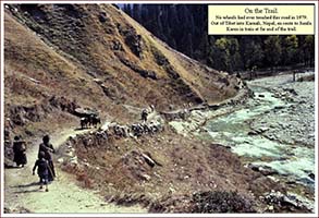
Through informed visualization I gained a sense of physical and temporal scale. Examples include realizing the immense size of the group, imagining how the lengthy train was spread along the trail to create groups of separated travelers moving together, accepting the pace of movement, hearing the horses snort, anticipating the next water by watching the panting dogs’ swollen tongues hang out, absorbing the impact of the landscape, sneezing in the dust cloud spawned by the livestock and travelers, hurrying to set camp and make repairs and care for the animals and eat a meager portion of food before dark, listening to the sharp rings of hammers striking iron as the forgers worked, and finally exhaling at dusk in view of the colorful tents.
Visualization helps direct attention to what needs to be investigated. As I visualized the travelers, I recognized that I needed to see their clothing, tents, and weapons—so I researched those items of material culture. Knowing that the expedition included livestock, I had to research animal tack as well as the issues of water and forage for the animals at campsites and along the trail, and this analysis required learning about the grasslands and vegetation of the sixteenth-century Southwest in North America. Visualizing the impact of water required information about weather, so I had to learn about Julian calendar dates and translate them into Gregorian dates, and vice versa in order to visualize, for example, seasonal water levels, to predict chances of rain or snow, and to imagine muddy or dusty trail conditions. My visualization sharpened with this knowledge, and I continued to hone that picture by filling in the details with constant research during my investigation, knowing that accurate visualization requires familiarity with the nuances of the historical and environmental setting.
When investigating actual locations, visualization coupled with experience helps one to recognize “out of place” elements or missing elements (both cases being anomalies) and so serves exploration by directing attention to the particular oddities present or absent. Visualization of a Coronado campsite, for example, reveals tent sites, forage, fuel supply, and water. During ground-truthing of a lead, should one or more of these desiderata be absent, a campsite becomes less likely.
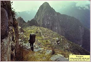
My life experience aided me with visualization. I have been accurately described as having “devoted much of my extensive travel in third world countries to long-distance, self-sustained walks of several weeks duration over native trade and settlement trails.” That experience was invaluable for helping me visualize the Coronado travelers.xv
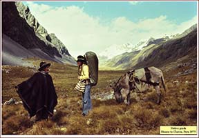
Essential ingredients in any exploration program are native guides, local people or residents familiar with the land, history, and current state of affairs of their turf. In their neighborhood, ranchland, or homeland, native guides possess the crucial element of “a foundation for an opinion.” One of the challenges faced by explorers is to gain the trust and the information of natives. Addressing the benefits brought by a native guide, archaeologist Stephen H. Lekson declares: “No archaeologist can ever know the archaeological landscape as well as an interested rancher. The expertise of nonprofessional locals may be very important to the success of a reconnaissance....”xvi I am in hearty accord. For many years before my hunt for Coronado, and as a consequence of my place of residence and my normal outdoor activities and travels, I built relationships with locals, especially with ranchers and other landowners of New Mexico, Arizona, and Mexico. This rapport has provided me and the Coronado project well-informed consultants for considerations.
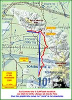
Local guides can aid in visualization. One of my foremost concerns, indeed one of the anchors of my trail prediction, was to determine where Coronado crossed the Río Gila and ascended the Mogollon Rim. Because of the most probable ways to arrive at the river, I considered the two most likely crossings to be Sheldon, Arizona, or Hidden Valley, New Mexico, with an ascent near those locations (map 2). During consultation, my native guides—resident ranchers and hunters—painted a vivid verbal picture of the challenging landscape that Coronado and his livestock would have endured during a climb from Sheldon, and I suspected that the captain general was smarter than that. Those who rejected the Sheldon climb accepted the proposed Blue Creek ascent from Hidden Valley, and I did, too. Later, I would be shown a buckle of sixteenth-century style found at Hidden Valley, adding credence to that route.
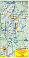
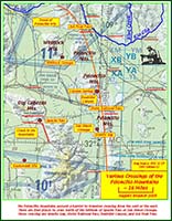
My ambition was to advance at least some of the leads to prospect status and, eventually, to discover a Coronado campsite. Perhaps most exciting was that my exploration map revealed a classic play: the leads were not scattered but rather showed a likeness to each other and were all situated along a trend, the Coronado Trail. Maps 1 and 2 display the leads and trail I proposed.
Elevation of leads required field observations where possible, precise knowledge of the land ownership always, and ease of access to conduct surface reconnaissance and metal detecting. Foremost, however, a lead must have the proper geological setting: stratigraphy that will hold an artifact. In the case of Coronado, that environment had to be a sixteenth-century surface that could be searched with a metal detector.xvii
My definition of a sixteenth-century surface is compound. From a traditional point of view, it is a surface where the sediment representing that time was buried and has remained in situ since the sixteenth century. In other words, the sediment has not been uncovered by erosion, and the artifacts still sit in their time and place of deposition. Broadening my definition, I also include exhumed surfaces where sixteenth-century sediment may have been removed by erosion but where artifacts deposited at that time remain at that spot. In both instances, the critical consideration is whether or not the artifacts remain in their primary depositional locations, and in all cases they do.
I consider an exhumed surface or landscape in the Southwest to be a land surface that is exposed by erosion and on which soil is thin and recent, or absent. Topographic benches, eolian-eroded desert pavement, and “blowouts” in sand dunes, to name a few, are features where these exhumed surfaces are exposed. It was on an exhumed surface that my team found Coronado artifacts at Kuykendall Ruins and Minnie Bell. Exposed landscape offers a double-edged sword: artifacts cannot escape the surface; but the artifacts of all ages are mixed together. So, the sixteenth-century pieces are not isolated on that surface. Impediments to sixteenth-century surface metal detector exploration are flooding or wind that either carry the surface and its artifacts away or bury them beyond the range of the detector.
My practice of focusing on appropriate stratigraphic surfaces is not unique. Anthropologist Loren Davis likewise focuses on specific stratigraphy for in situ artifacts. He explains, “If you expect to find evidence of occupations 15,000 years old, where better to look than in 15,000-year-old soils.”xviii Richard Flint considers a geological sixteenth-century surface to be one that is represented in a historical context by documents written in that century, not before or after. In other words, he defines the historical surface by the date of writing. Moreover, Flint requires that the translation of the document must adhere to sixteenth-century vocabulary: “To return, though, to the worthwhile concept of a ‘sixteenth-century surface,’ there is an equivalent in translating historical documents. One strives to render the language in a way that is in keeping with sixteenth-century beliefs, habits, and practice.”xix In this spirit, my insistence on reading only the original source documents ensured that I likewise focused on a sixteenth-century historical surface. I am certain, however, that I did not always translate the Spanish with sixteenth-century understanding.
Whether or not a sixteenth-century surface existed on a lead could not always be known. Good prospecting demanded that no lead could be rejected or advanced until a surface examination had been completed. Using these measures, I elevated some of the leads to prospects, while killing others.
Exploration is dynamic. During an exploration program, many gears of the project are turning at the same time because multiple leads are being investigated simultaneously. Reconnaissance of landscape, metal detecting in the field, discussions with local guides, locating and negotiating access with landowners, identifying artifacts, and consulting with laboratories were always in play during my search for Coronado. This multifaceted process produced a flow of events and a chain of moods that included easy cruising, abrupt change, volatility, reversal, distress, disappointment, waiting, viento en popa, and elation.
All leads exhibit pluses, negatives, omissions, and questions, so the exploration geologist must constantly problem-solve in order either to advance or kill a lead, and the practice must be heartless. My aim is always to discredit leads rather than support them; by experience I know that support of a valid lead will appear in the process. Geologists who cannot cast their romance aside and properly scrutinize their leads are disparaged as “falling in love with their prospect.” Even worse, prospectors who conspicuously and intentionally fail to kill their flawed leads are disdainfully accused by astute geologists of “selling a deal rather than presenting a prospect.”
In the case of my Coronado exploration, examinations of the landscape and land ownership were the two issues most determinative of a lead’s survival. If a lead endured the landscape analysis, but the landowner was unwilling to allow the exploration, the lead was effectively killed for the short term but not necessarily for the duration. Death by a disqualifying landscape, however, ensured that the kill was permanent under the existing paradigm, technology, and operational constraints.
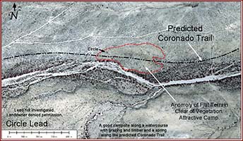
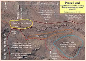
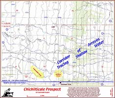
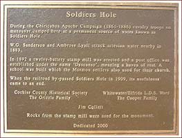
Soldiers Hole (map 2) represents a lead supported by the landowner, but the prospective campsite was deeply covered with post-Coronado-era sediment that rendered the sixteenth-century surface beyond reach of current metal detector technology and demoted the site to the untestable category. These conditions effectively killed Soldiers Hole until the appearance of new technology. Such geologic conditions prompted us to coin the phrase, “He may be here, but we probably won’t find him.” This pronouncement sent us on our way to seek better opportunities.
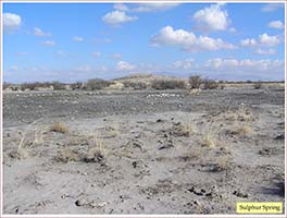
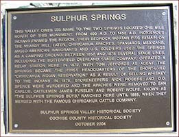
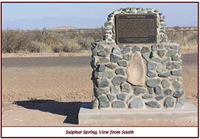
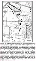
The Sulphur Springs lead (map 2) passed the landscape and ownership tests, but was diminished by lack of a pueblo ruin. Dates on our expedition calendar demanded a pueblo campsite at that time, and there was no evidence of one there. The demotion of Sulphur Springs elevated the pueblo of Kuykendall Ruins (map 2), where both landscape and ownership passed the test, and where our exploration discovered what we believe to be Chichilticale, the famed Red House of the Coronado saga. The Whitlock Cienega lead (map 2) was condemned because it sat on the way to a steep, rugged, and waterless ascent near Sheldon, Arizona, that could not be climbed by droves of livestock. The topography killed that route and the leads on it. xx
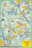
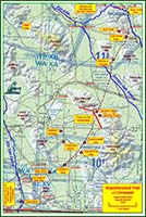
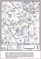
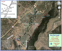
Experienced prospectors know that exploration is dynamic and that circumstances and technology can change suddenly. A landowner may unexpectedly allow exploration, or ownership can change so that permission to explore can be requested anew. My prospect at Dutch John (map 1) awaits such a turn of events. Technology may advance so that a prospect becomes testable. My currently untestable prospects at Soldiers Hole (map 2), Río Frio, and Hardcastle (map 1) await remote sensing advances that can detect small pieces of metal at depths beyond the current limits.
The Hidden Valley lead (maps 1–2) offers an example of how risk and operations affect exploration. Ground inspection revealed a destructive flood plain landscape on the Río Gila, steep mountainsides on the banks of the river, and land ownership issues at the principal topographic bench sites. Other complications included a rugged, remote, and difficult-to-reach location. My team and I concluded that any search at Hidden Valley would have a high probability of failure and represented a high-risk hunt. Equally important, conducting a search there included traversing difficult roads and required lengthy travel times to reach harsh, hostile hunting grounds. Consequently, we demoted Hidden Valley to untestable, effectively killing it under the existing paradigm. Unknown to me at the time, however, was that a rancher had found a buckle on the mountainside of the north bank of the river at Hidden Valley. We were subsequently shown the piece in a private collection, and we identified it as sixteenth-century Spanish in style. This consequential find at a lead on my predicted trail suggests that the buckle is not a stray, and strengthens my contention that Coronado camped at Hidden Valley on St. John’s Day in 1540.xxi
In order to pursue a historical lead, as well as a geological lead, permission to explore must always be obtained from the landowner. This single issue most constrained our Coronado program. Should a lead fall on federal or state land, death was instantaneous because we were not technically qualified for grant of a permit. Private land presented a different problem. Our pursuit of Coronado intrigued most landowners. The hunt was not the issue. The find was the problem. Landowners feared that the government would seize their property if Coronado were shown to have occupied a portion of it. Despite this ubiquitous concern, I was able to secure permission to explore on several private land leads, propelling the program into the field exploration phase.
“Found” or “not found” are the possible ultimate results of search. Oil elephants and their historical and archaeological equivalents are rare, meaning that only infrequently are they discovered. Risk evaluation always considers rarity of target. Experienced elephant hunters are by nature romantic, optimistic, and hopeful in the face of risk, while at the same time aware that their chances of finding what they seek are quite minimal. Their sober expectations acknowledge failure as most likely because of the high-risk hunt in which they participate.
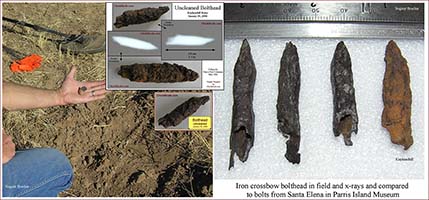
Elephant hunts begin hopefully but are accompanied by earned skepticism. Search duration and results dictate when and whether attitudes change: if positive evidence mounts, confidence builds, and vice versa. Regardless of confidence, it is mandatory that the concept that created the prospect be thoroughly evaluated. Some concepts can be tested and accepted, or condemned quickly, but others demand labor-intensive attention. Once certain requirements are met, commitment to the prospect becomes obligatory. This means that the search must continue, even when no artifacts are being recovered, until the evaluation is complete. Stopping a search before it is conclusive is like drilling a borehole but not properly evaluating it. Petroleum exploration geologists describe this as “installing a hole instead of testing a prospect.” Such behavior is likewise pointless in seeking evidence of the Coronado expedition. Equally effective at propelling a search to exhaustion is to confirm the concept quickly by discovery of a significant artifact. Such was the case at Kuykendall Ruins, for instance, when we found an iron crossbow bolthead during the opening week of the first of three field seasons there.
Of foremost importance in my search for the captain general was to recognize the signs of Coronado if we came upon him. In 2004 the play was immature. Collections and knowledge of sixteenth-century artifacts in the American Southwest were so emergent that one had to visit the southeastern United States, Latin America, and the Caribbean to consult with the leading researchers or to examine artifacts of the Coronado era that had been found in the New World and identified as sixteenth-century Spanish. Descriptions of camps were entirely speculative; one could not look in a book to see one. The play was justly characterized as searching for the postulated camps and unfamiliar artifacts of a scantily documented event. Recoverable artifacts carried by Coronado expedition travelers were composed of metal, ceramic, and stone. I concluded that metal detector technology and pedestrian surface exploration represented the appropriate search techniques for these elements in a southwestern environment and that the search pattern should be along closely spaced parallel lines on a sixteenth-century surface.
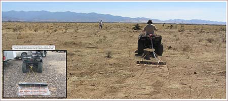
Given that I had never used a metal detector, I learned in the field. The first season’s experience revealed the labor and time intensity of handheld detectoring, and the uncertainty of achieving an exhaustive search. This awareness prompted my team to innovate a solution, resulting in fabrication of the Blennert sled, a faster, easier, and more-thorough method of large-area remote sensing that utilized a metal detector. International meteorite and gold prospector John Blennert designed the sled, a meter-wide metal detector coil mounted on a pad and pulled by an operator wearing headphones. This single innovation contributed mightily to our success.xxii
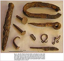
Earlier, I mentioned that drillers sometimes fail to recognize the oil zone as they drill through it. Being at the right place and using the correct detection techniques do not ensure success. Even if an explorer finds what he seeks, he may not realize it, so the prize remains only found, not discovered. Identification of objects is critical, and with each find my team earned the duty of identifying the piece and its age. Fig. 2 illustrates a variety of artifacts we recovered in the field.
Of first value in identifying potential Coronado-era artifacts were photographs, sketches, and illustrations of confirmed sixteenth-century objects. However, the comparison of our finds with sixteenth-century Spanish pieces in reputable collections was most desirable and was mandatory for my own due diligence. Seeking counsel to aid with identification demanded that we be confident that our chosen examiner had a foundation for the opinion rendered.
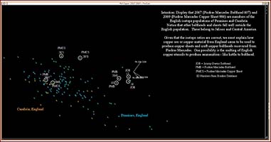
Most modern artifacts were easily identified, but others were problematic and became labor-intensive research projects. Some artifact identification required original laboratory work on the specimen, such as geochemical analysis. New technology could expose clues not previously recognized in old records, and this awareness served us well during the hunt for Coronado. A geochemist, a statistician, and I, a geologist, united for a multidisciplinary attempt to identify artifacts containing lead found on suspected Coronado sites. We utilized computer technology to display lead isotope ratios from published archival databases in new ways so as to identify the lead source mine.
Our method was one of dynamic display as opposed to the static display used by contemporary archaeologists. Traditional inquiries of lead isotope ratios utilized inert two-dimensional plots of the ratios to suggest source mines for the lead. Our innovation was to display the ratios in three-dimensions and to put them in motion in order to determine visually which ratios traveled together. We interpreted these ratios as originating from the same source mine. We found that rotating the plotted ratios greatly enhances our confidence in isolating lead sources for my team’s artifacts. Moreover, by revealing the limitations of traditional two-dimensional displays, our technique improved our ability to interpret those traditional static graphs. In the end, we saw that the results of each technique supported the other, elevating confidence in our assignment of the source mine for individual lead balls.xxiii
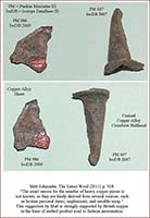
By knowing the provenance of the lead, coupled with the history of human presence where the artifact was discovered, we could consider by whom, when, and how the lead artifact arrived at that spot. Using the detective metaphor, our analysis provided means, motive, and opportunity for the presence of the lead shot. Respecting non-conical lead ammunition, our technique provided identification of an otherwise nondescript gray ball and thus elevated our confidence in conclusions reached by awareness that a specific shot was molded of lead from a Spanish source.xxiv
Identification of an artifact, however, did not always determine its age. Following the counsel of historical archaeologist Kathleen Deagan, I utilized the categories of “cannot be excluded” from the sixteenth century and “is consistent with” the sixteenth century. In response to Richard and Shirley Flint’s request, I explained: What I mean by “consistent with the sixteenth century” is that an individual artifact consistent with the sixteenth century is one of a type that has been found at sixteenth-century sites, and of a type that was available during the sixteenth century. This is not to say that the artifact is doubtless from the sixteenth century, rather that it could be, that it is not in conflict with the sixteenth century, and that it “cannot be excluded” from the sixteenth century.”xxv
I shared my interpretation with Deagan, who responded: “I think you have it right with “consistent with the sixteenth century.” There are a lot of artifacts (most of them actually) that have a long time span that includes the sixteenth century, and before and after (like wrought nails or unglazed coarse earthenware), so in the absence of diagnostic artifacts of ONLY the sixteenth century, as well as the absence of artifacts that definitely DON’T date to the sixteenth century, an assemblage can be consistent with the sixteenth century, but not necessarily of the sixteenth century.”xxvi
These two categories provided a flexible framework but specific criteria with which my team could evaluate and date artifacts recovered from the field.
An exhumed surface forces an additional step in artifact identification. Our finds on exhumed surfaces included artifacts ranging from modern aluminum cans to sixteenth-century iron spikes. Since our duty included assigning dates to artifacts, this task was complicated by the presence of pieces whose ages spanned nearly five centuries, all resting on the same surface. Under these circumstances, historical records can provide clues superior to what can be gleaned from geology. Our process called for sorting the pieces into age categories, including one titled “unknown.” History can suggest who was present, when, and for what motive. Historical chronology, based on research, provides a calendar of opportunities for a given artifact to have arrived where it was found and suggests who might have had the means and opportunity to deposit it. By this process of identification, we produced a collection of individual artifacts that could not be excluded from the sixteenth century and that likewise composed an assemblage consistent with the sixteenth century.xxvii
Oil geologists will hope they have discovered an oil field, but the verification will appear only after the discovery well has produced enough oil to cause the drilling of additional, ensuring that the discovery was not just a single well but indeed a field composed of multiple wells.
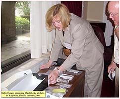
Verification of discovery of a Coronado campsite is less empirical. Archaeologist Charles R. Ewen, is a veteran of excavation and exploration of Hernando de Soto’s Anhaica camp of 1539–1540 at the Governor Martin site in Tallahassee, Florida, and was a participant of the Hispaniola exploration program of 1975–2002, which evaluated Puerto Real in Haiti, and La Isabela and La Vega in the Dominican Republic. He served as president of the Society for Historical Archaeology during the 2014–2016 term. Ewen addressed the confirmation issue for the sixteenth-century Spanish Anhaica site, describing what I have branded the “Ewen Test.” A test for site verification, his criteria are applicable to determining Coronado presence as well as other historical occupations.xxviii
The Ewen Test for a sixteenth-century Spanish site in the New World requires that the historical narrative describing the landscape should be discernible in the modern setting. The test also requires that an assemblage of artifacts, not just a single piece, be recovered, and that the artifacts be utilitarian European pieces, not exclusively trade items. According to the Ewen Test, however, having all the requirements in place is not proof that the site is a specific one sought by the explorer or team, rather that the site is a contender for the one in question.xxix
To examine my speculative inclinations, as well as to demonstrate the pitfalls of creating and interpreting contour maps, my oil exploration trainers periodically provided a map with the initial dataset presented and asked me to draw the contour lines on it. Afterward, they gave me a second dataset and I recontoured the map to incorporate, or “honor,” the new data. Honoring the second dataset always changed the first map dramatically. A third dataset was then provided, and the revised contouring again changed the map, while at the same time enhancing the precision. After a fourth and fifth dataset were incorporated, the map tended to stabilize so that no relevant precision was gained by adding more datasets. These observations demonstrate that adding data to contour maps improves them but that the most-accurate maps are not necessarily the ones utilizing the most data. Instead, they are the maps that do not change when data are added.
The contouring exercise illustrates that adding layers of evidence, or inferences, serves to focus the examiner on sustainable options by excluding unacceptable options, and concomitantly reduces the number of options that best fit all the evidence. Interpretations should be based on best options, with as few options as possible in play. The more layers of evidence that can be added without changing the interpretation, the stronger the interpretation.
Exploration geologists observe anomalies on maps and in the data. Anomalies are features that do not fit the surroundings; they are unusual and eye-catching, often interpreted as data errors until recognized as legitimate phenomena in the environment. Exploration geologists intentionally seek opportunities to draw anomalies on contour maps because oil fields are anomalies. The geologist must be able to account for anomalies. The first and most pertinent question at map presentation is “How do you explain that?”
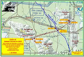
The anomaly may be the absence of a factor as well as the presence of one. As I mentioned earlier, “conspicuous by its absence” is always an appropriate remark when such is the case, because absence is a clue addressing means, motive, and opportunity. Along the same line of thinking, presence of specific evidence implies that specific corollary evidence will be present also. For instance, geological evidence of a former river emptying into a shallow sea indicates a likely delta at that spot; a single way through a landform is likely the trace followed by travelers.xxx Map 3 illustrates the geological anomaly at Apache Pass, where the trend of the mountain range changes and creates a passage.
Creative oil exploration geologists predict where anomalous and undiscovered geological features are likely to be located. One technique is to compare strata in every well in an area to strata in every other well in that area. Such practice of multiple well comparison serves to demonstrate relationships between wells that suggest specific locations where geological features of interest may be hidden. For purposes of historical identification of features, such as landmarks or place names, I compared travel times from a common departure location by distinct parties to different places, thereby identifying the departure location by its distance from multiple locations.
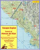
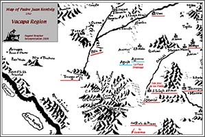
The location of Vácapa offers an example. The Savoyard friar Marcos de Niza first mentioned this place during his trip north to Cíbola. In order to predict the location of Vácapa, I studied Marcos’ report and added to it my knowledge of the terrain and its Native occupants of 1539. I concluded that San Jose de los Pimas, in municipio La Colorada, southeast of Hermosillo, Sonora, Mexico, is the modern-day location of Vácapa. Only by comparing multiple reports and travel times by reconnaissance groups sent by Marcos to several sites could I reach the conclusion that San Jose de los Pimas was the common point of departure and was the historical Vácapa.xxxi
Evidence, anomalies, and conclusions are conditional upon thoroughness. Map presentation exposes geologists who fail to practice this quality. The greatest humiliation is to have a colleague point out that a map is incomplete and misleading because available data that directly affects the prospect was missed—not excluded or misinterpreted—but missed due to lack of thoroughness. This unfortunate event serves not only to disqualify the prospect but to tarnish the credibility of the prospector, too. Historical exploration demands equal thoroughness to establish proof.
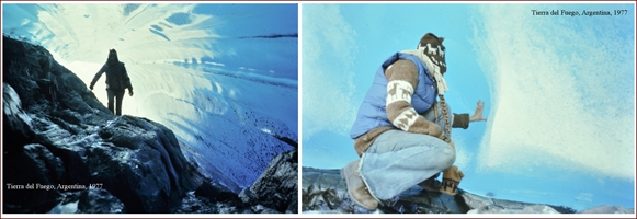
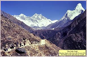
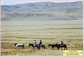
Occasionally during my search for Coronado, I reflected on times in South America and Asia when processions of pack animals and Natives, with me mixed amongst them, extended for kilometers along trails never touched by wheels. These recollections provided me the essential clue of scale, which subsequently suggested its relative dynamic—time. Calendars can be created if time is known, and I needed a calendar to track Coronado. Conceptualization of scale and time, influenced by my travels, aided me decidedly while I considered possible routes of the Coronado expedition, and likely contributed significantly to any success my team and I may have enjoyed.
Personal aspects that came to bear on my hunt included the art of mapping, my background in exploration geology, my understanding of human interaction with the landscape, and my familiarity with the Spanish language. In the context of this report, my skills and experience aided me in reading and interpreting original source documents in their original language, visualizing the travelers, and creating an exploration map with leads. While my background did not provide me the means to identify sixteenth-century objects recovered in the field, my exploration methodology alerted me that I would be required to do so, and that my exploration experience would guide that identification inquiry.
The Coronado play will likely not end, but be continued by others. My methods appear, at this writing in the summer of 2015, to have facilitated recognition of four locations of Coronado presence: Kuykendall Ruins, Doubtful Canyon, Hidden Valley, and Minnie Bell. For this alone, the methodology is worthy of passing along to the next generation of Coronado explorers and to historians conducting searches, be they in the field or the archives.
First and foremost I recognize those master exploration geologists who trained me and who provided the foundation that led to this writing—I hope all of them are “runnin’ high and lookin’ good.” My father was an exploration geologist, and I am confident that he influenced me more than ever could I realize, and I salute him respectfully and warmly. Editors Durwood Ball and Richard Flint must be thanked for their encouragement, support, and guidance of my Coronado publications. For providing much appreciated thoughtful comment on this report, I am grateful to Matt Schmader, Mike Waters, and Lon Lehr. With sober sadness I recollect my enduring memories of Bernard L. “Bunny” Fontana, reader and thoughtful supporter of all my reports, including this one. Bunny passed away on 2 April 2016. All students of the Borderlands will miss him. To my exploration team, no words of gratitude suffice. We grouped together for years, hunting and finding and smiling. We moved from prospect to prospect, making discoveries. Those years were magic. What an honor to have hunted with each of you. Lastly, and following tradition, there will be no break here in the policy of ending my reports with expressions of love and respect for Karen Whiteside Brasher, who appeared among those long trains of travelers in far away countries, we together learning how to walk.
1. I consider this report as an essential and obligatory complement to my proposals of a Coronado presence at the sites of Kuykendall Ruins, Doubtful Canyon, Minnie Bell, and Hidden Valley. In June 2015, editor Durwood Ball and historian Richard Flint encouraged me to describe for publication the methodology that I employed during my exploration for Coronado. They did not want a results paper, rather suggesting a process paper, or a “think piece,” to inform historians, whom they identified as the principal audience for this essay. Such a request was not totally new. In 2007, before publication of this essay, both Flint and anthropologist Carroll L. Riley encouraged me to present my reasons for settling on my proposed route and not simply to present just my findings, a recommendation to which I subscribed. This report advances their request, addressing how I approached the inquiry, as opposed to reporting only what I concluded and why. Readers should be aware that this essay on methods updates no exploration since February 2013. My previous reports on my search for Coronado are Nugent Brasher, “The Chichilticale Camp of Francisco Vázquez de Coronado: The Search for the Red House,” New Mexico Historical Review 82 (fall 2007): 433–68; "The Red House Camp and the Captain General: The 2009 Report on the Coronado Expedition Campsite of Chichilticale," New Mexico Historical Review 84 (winter 2009): 1-64; "Spanish Lead Shot of the Coronado Expedition: A Progress Report on Isotope Analysis of Lead from Five Sites," New Mexico Historical Review 85 (winter 2010): 79-81; “Francisco Vázquez de Coronado at Doubtful Canyon and on the Trail North: The 2011 Report Including Lead Isotopes, Artifact Interpretation, and Camp Description,” New Mexico Historical Review 86 (summer 2011): 325-75; “The Coronado Exploration Program: A Narrative of the Search for the Captain General,” in The Latest Word from 1540: People, Places, and Portrayals of the Coronado Expedition, ed. Richard Flint and Shirley Cushing Flint (Albuquerque: University of New Mexico Press, 2011), 229-61; “The Francisco Vázquez de Coronado Expedition in Tierra Doblada: The 2013 Report on Artifacts and Isotopes of the Minnie Bell Site at Big Dry Creek, Catron County, New Mexico,” New Mexico Historical Review 88 (spring 2013): 179-227. Expanded versions of these publications are presented at http://www.chichilticale.com/.
2. Historians prefer the descriptor primary source document as opposed to original source document. The detective metaphor has been used by three social scientists to describe my exploration approach to the Coronado search. One portrays the process as “an important piece of intellectual sleuthing.” Another characterizes it as “historical and archaeological sleuthing.” Still another comments, “Reading over your article reminds me that we, raised in the humanities, who refer loosely to our ‘detective work’ are only blowing smoke.” Richard Flint, email to author, 9 September 2006; Thomas Bowen, letter to author, 20 December 2007; and John L. Kessell, letter to author, 29 April 2010.
3. The era of my geological training was during the transition from handwork to computerization in petroleum exploration geology. My trainers taught me the traditional handworking skills. Change was rapid, and within a little more than a dozen years, computerization had effectively replaced the two most important of these skills, interpreting original source documents and drawing by hand the contours on regional exploration maps. Source documents had been interpreted and encoded into abbreviated forms retrieved on computer terminals; the geologist seldom, if ever, unrolled maps drawn on linen or handled old, inked paper in libraries or file cabinets. Computer contouring offered ease and convenience at the expense of a custom map drawn by the exploration geologist. This algorithmic map replaced the imaginative, concept-driven maps previously contoured by hand, and subsequently, the skill of regional hand contouring quietly disappeared for lack of young geologists practicing the art. For a colorful history of data gathering by oil scouts, see Clarence C. Pope, An Oil Scout in the Permian Basin, 1924–1960 (El Paso, Tex.: Permian Press, 1972), esp. 9–45.
4. Archaeologist Mathew F. Schmader comments: “I very much appreciated the exploration geologist’s approach to trying to kill a lead. This is precisely what the philosophers of science call falsifiability, as best elaborated by philosopher Karl Popper. What Popper said was that hypotheses must be framed in such a way that they can be easily falsified, and that the conduct of research should be the effort to prove one’s self wrong. Schmader attached a quotation of Popper: “Whenever a theory appears to you as the only possible one, take this as a sign that you have neither understood the theory nor the problem which it was intended to solve.” Matt F. Schmader, email to author, 25 September 2015. [For an introduction to falsifiability, see Karl R. Popper, The Logic of Scientific Discovery, 2d ed. (New York: Basic Books, 1959; London: Routledge, 1992), 78–92. Citation refers to Routledge edition. Originally published as Logik Der Forschung (Vienna: Springer, 1935).]
5. The only description of a sixteenth-century camp available to me in 2004 is found in a book, published in 1599, about the practice of warfare by Spanish expeditions— the first such book on the topic in the New World. See Bernardo de Vargas Machuca, Milicia y Descripción de las Indias (1599; reprint, Madrid: Librería de Victoriano Suárez, 1892), book 2, pp. 209–217. In May 2005, archaeologist Jonathan E. Damp published his study of the battle site at Hawikku and the Coronado presence at Kyakima. This publication includes photographs of artifacts and maps locating them within the battle site, but there is no map of the expedition camp, which searchers did not find. See Jonathan E. Damp, The Battle of Hawikku, Research Series 13, Report no. 884 (Zuni, N. Mex.: Zuni Cultural Resource Enterprise, 2005). Sixteenth-century artifacts available to me for examination in 2004 in the Southwest included pieces from the Jimmy Owens and Hawikku sites, although other collections existed.
6. Archaeologist Mathew F. Schmader points out several instructive examples of southwestern archaeologists’ failure to recognize a Coronado discovery. He writes: “Mostly during the 1920s and 1930s, we had archaeologists who were making conscious efforts to try and find the physical evidence of the expedition. But even when they did find it, it didn't translate to anything! Witness archaeologist Frederick W. Hodge, working at Hawikku and finding crossbow boltheads that he thought were pen nibs in 1926! Or archaeologist Marjorie F. Tichy (Lambert) excavating a skeleton at Santiago in the mid-1930s with a crossbow bolt in its ribcage and not connecting the dots to Coronado. Or archaeologist Alfred V. Kidder, working at Pecos in the late [19]20s and finding Coronado-era artifacts without proclaiming them as such.” Schmader, email to author, 25 September 2015. For a discussion of copper boltheads found at Santiago Pueblo and Pecos Pueblo, see Margaret Ferguson Tichy, “The Archaeology of Puaray,” El Palacio 47, no. 7 (July 1939): 145–163; Alfred V. Kidder, The Artifacts of Pecos, Papers of the Southwestern Expedition, no. 6, (New Haven: Yale University Press, 1932), 308. Several scholars discussed potential or unrecognized sixteenth-century artifacts recovered prior to 1989. See Bradley J. Vierra, A Sixteenth-Century Spanish Campsite in the Tiguex Province, Laboratory of Anthropology Notes, no. 475 (Santa Fe: Museum of New Mexico, Laboratory of Anthropology, Research Section, 1989), 12–13; Frank R. Gagné Jr., “Spanish Crossbow Boltheads of Sixteenth-Century North America: A Comparative Analysis,” in The Coronado Expedition: From the Distance of 460 Years, ed. Richard Flint and Shirley Cushing Flint (Albuquerque: University of New Mexico Press, 2003), 242–44; Diane Lee Rhodes, “Coronado’s American Legacy: An Overview of Possible Entrada Artifacts and Site Types and a Discussion of Texas Sites,” Bulletin of the Texas Archaeological Society 63 (1992): 27–51; and Diane Lee Rhodes, “Coronado Fought Here: Crossbow Boltheads as Possible Indicators of the 1540–1542 Expedition,” in The Coronado Expedition to Tierra Nueva: The 1540–1542 Route across the Southwest, ed. Richard Flint and Shirley Cushing Flint, (Niwot: University Press of Colorado, 1997), 51–53.
7. In an email to me in 2015, Richard Flint described the state of the Coronado dataset in 2004, prior to the publication of Documents of the Coronado Expedition, 1539–1542: “They Were Not Familiar with His Majesty, nor Did They Wish to Be His Subjects,” ed. and trans. Richard Flint and Shirley Cushing Flint (Dallas, Tex.: Southern Methodist University Press, 2005). Flint writes:
“Never, before our publication, have both translations and transcriptions of all 34 documents it comprises been published together. [George Parker] Winship did publish [in 1896] both Spanish and English versions of the Traslado de las Nuevas, the Relación Postrera de Cíbola, and Castańeda's Narrative. He also published translations only of [Viceroy Antonio de] Mendoza's Letter to King, 1540; Coronado's Letter to Mendoza, 1540; La Relación del Suceso; Coronado's Letter to the King, 1541; [Juan] Jaramillo's Narrative; [Hernando de] Alvarado's Report; and the Hearing on Depopulation Charges, 1540. In general, Winship utilized the very poor transcriptions that had been published by [Joaquín] Pacheco y [Francisco de] Cárdenas in Spain in the late nineteenth century.
In 1940, George Hammond and Agapito Rey published English translations only of all the same documents Winship had published, plus Coronado's Letter to the King, 1538; Letter of Mendoza to the King, 1539; Coronado's Letter to the King, 1539; Coronado's Appointment as Governor of Nueva Galicia, 1539; Instructions to Marcos de Niza and fray Marcos's Report, 1538, 1539; Appointment by Mendoza of Coronado to Command the Expedition, 1540; Muster Roll, 1540; [Hernando de] Alarcón's Narrative, 1540; Instructions for a Second Trip by Alarcón, 1541; Licenciado [Lorenzo] Tejada's Commissions; Coronado's Testimony on the Expedition, 1544; López de Cárdenas's Testimony Regarding the Expedition; Sentences of López de Cárdenas; a few selections from Coronado's Residencia; Sentence of Coronado; Charges Against [sic]Coronado with Regard to the Expedition; and Coronado's Exculpatory Sentence. Hammond and Rey, in general, prepared their own transcriptions from the original documents, but they did not publish any of them. The general problem with Hammond and Rey is that they often paraphrased rather than translated. All around, then, their volume is a poor choice for a serious scholar, just as are the transcriptions of the Pacheco y Cárdenas team.
Documents of the Coronado Expedition includes most of the documents Winship and Hammond and Rey published, plus Spanish transcriptions and English translations of 14 relatively short documents that have never been available before in print in their original language, English translation, or both. Add to that the documents published for the first time, both in Spanish and English, that are included in [my book] Great Cruelties Have Been Reported, and we have made available in Spanish and English a wealth of information not available before in one or both languages, except in manuscript form in the various archives where they reside. And of course in your case it was the Spanish transcriptions that you needed, almost none of which had previously been published [author’s emphasis].
We [Shirley Cushing Flint and Richard Flint] went over this information in the introduction to Documents of the Coronado Expedition. There have been a number of people who, in the past, have disparaged our accomplishment in publishing Documents of the Coronado Expedition. These tend to be people who do not have the ability to read the original Spanish and think one translation is as good as the next. Thus, they wouldn't be able to [compare], and certainly have not, compared[,] our transcriptions to those of Pacheco y Cárdenas or Hammond and Rey, in those cases in which that would be possible. Such critics, therefore, have no way to competently compare Hammond and Rey's translations with ours, when we have both translated the same documents.” Richard Flint, email to author, 26 September 2015.
8. Exploration is a proactive pursuit; an explorer actively seeks a target by his own design. The contrast to exploration is development, which is reacting to a discovery, that is, developing it. For an authoritative discussion of how to develop a discovery, see Charles R. Ewen and John H. Hann, Hernando de Soto among the Apalachee: The Archaeology of the First Winter Encampment, Ripley P. Bullen Series (Gainesville: University Press of Florida, 1998): prologue, parts 1–2.
9. Exploration dollars are ever in demand, are always difficult to obtain, and inevitably come with conditions and restrictions. The most-common outcome of exploration is failure, the tragedy that risk-averse investors most fear. Budget-driven exploration most often fails because by definition, it is constrained and thus tends to become listless and to fade away due to lack of continuity. Self-supported explorers enjoy the advantage of not having to seek funds but expose themselves to the risk of losing their own money. As I have reported previously, “Fortunately I had time and capital on my side, which I fully employed to whatever extent necessary.” Brasher, “The Coronado Exploration Program,” 255.
10. Brasher, “The Coronado Exploration Program,” 234.
11. Brasher, “The Coronado Exploration Program,” 239, map 9.2, p. 258n33.
12. I read the transcribed Spanish versions of the Coronado source documents, not the original handwritten accounts. Were it not for the transcriptions of these original documents by Richard Flint and Shirley Cushing Flint, my adventure with Coronado would have never happened. For a discussion of the desirability of starting “as much from scratch as possible,”—from the transcriptions— see Brasher, “The Coronado Exploration Program,” 232–33. As my exploration continued, I composed four additional journals: “The Search for Chichilticale,” 261 pages; “Confirmation at Chichilticale,” 237 pages, “Conclusion at Chichilticale,” 195 pages; and “Coronado Beyond Chichilticale,” 203 pages.
13. Richard Flint, email to the author, 15 June 2015.
14. This recognition of intuition as valuable in exploration is noted by the late B. W. Beebe, former vice-president of the American Association of Petroleum Geologists, who describes exploration geologists’ technical skills as including “perhaps a bit of mysticism.” B. W. Beebe, "Philosophy of Exploration," in Oil Is First Found in the Mind: The Philosophy of Exploration, ed. Norman H. Foster and Edward A. Beaumont, Treatise of Petroleum Geology, no. 20 (Tulsa, Okla.: American Association of Petroleum Geologists, 1992), 143. Richard Flint’s comment in email to the author, 15 June 2015.
15. Brasher, “The Coronado Exploration Program,” 491.
16. Stephen H. Lekson and Human Systems Research, Inc., Archaeological Overview of Southwestern New Mexico: Final Draft (Santa Fe, N. Mex.: New Mexico Historic Preservation Division, 1992), 164.
17. Previously, I have discussed the issue of a sixteenth-century surface in Brasher, “Coronado in Tierra Doblada,” 183, 185; and “Coronado Exploration Program,” 241, 253.
18. George Wisner, “Putting Muscle into Coastal-Entry Research,” Mammoth Trumpet 24, no. 3 (July 2009): 9.
19. Richard Flint, email to the author, 15 June 2015.
20. For discussions of killing the Whitlock Cienega and Sulphur Springs leads, see Brasher, “Coronado Exploration Program,” 235–37; and “Coronado at Doubtful Canyon,” 333–34.
21. A discussion of the Hidden Valley lead is found in Brasher, “The Coronado Exploration Program,” 235–36, 241, 249–50; "The Red House Camp,” 44–45; and “Coronado in Tierra Doblada,” 192–93.
22. The Blennert sled is covered in Brasher, "The Red House Camp,” 7–8.
23. For a detailed discussion of our analysis, visit this website: http://www.chichilticale.com/isotope.htm.
24. I first reported on this technique in Brasher, “Spanish Lead Shot,” 79–81.
25. Brasher, “The Coronado Exploration Program,” 257, no. 21.
26. Kathleen Deagan, email to the author, 9 February 2010.
27. For examples where I applied historical research and chronology for purposes of artifact identification, see Brasher, "The Red House Camp,” 40; “Coronado at Doubtful Canyon,” 340; and “Coronado in Tierra Doblada,” 185.
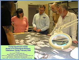
28. The “Ewen Test” is defined in Ewen and Hann, Hernando de Soto among the Apalachee, 52–53. The Hispaniola exploration program is described at http://www.chichilticale.com/travels.htm. An anecdote concerning site affirmation is instructive. The sixteenth-century occupation at Santa Elena, South Carolina, was excavated by Stanley A. South and others, including Chester DePratter, beginning in 1979, with the findings published nine years later. The recovered collection represents one of the finest of its time and kind in the New World. On 18 February 2008, more than midway through the second field season at Kuykendall Ruins, Karen Whiteside Brasher and I met with Stan South, Chester DePratter, and James B. Legg, the collection curator, in Columbia at the South Carolina Institute of Archaeology and Anthropology. Our aim was to show our Kuykendall Ruins assemblage and compare it to that of Santa Elena. Karen’s notes record comments by South and DePratter that illustrate the inherent inconsistencies of site affirmation. At one point, Stan said to me, “You have a large collection compared to Dave Moore, who can hold all his artifacts from an accepted Soto site in one hand.” Chester added, “You have a site—refine it.” Karen Whiteside Brasher, 17–23 February 2008, personal journal. For a description of the Santa Elena collection, see Stanley South, Russell K. Skowronek, and Richard E. Johnson, Spanish Artifacts from Santa Elena, Anthropological Studies, no. 7 (Columbia: South Carolina Institute of Archaeology and Anthropology, University of South Carolina, 1988).
29. Ewen’s requirement that a site yield more than one artifact currently causes Hidden Valley to fall short at qualifying as a Coronado site. Only one artifact has been recovered there. However, Hidden Valley remains a location where a Coronado presence was predicted and subsequently exhibited, albeit by a single piece of evidence, and this finding elevates the status of the buckle above that of a stray. For the Ewen Test, see Brasher, “The Red House Camp,” 53.
30. Previously, I have written about “only” places. See Brasher, “The Coronado Exploration Program,” 244, 246; and Brasher, “Coronado in Tierra Doblada,” 183.
31. Fray Marcos de Niza, “Narrative Account by Fray Marcos de Niza, August 26, 1539,” in Documents of the Coronado Expedition, 1539–1542, ed., trans., and annot. Flint and Cushing Flint, 68–69, 80–81. In 2011 I published my proposed location of Vácapa. See Brasher, “Coronado at Doubtful Canyon,” 352, map 4. Marcos was from the Duchy of Savoy in the northern Italian peninsula.